
Oregon Cascades Under Winter Storm Watch April 1 to 2 as Santiam Pass and Willamette Pass Face 10 to 18 Inches of Snow With Hazardous Travel Conditions Across Cascade Passes
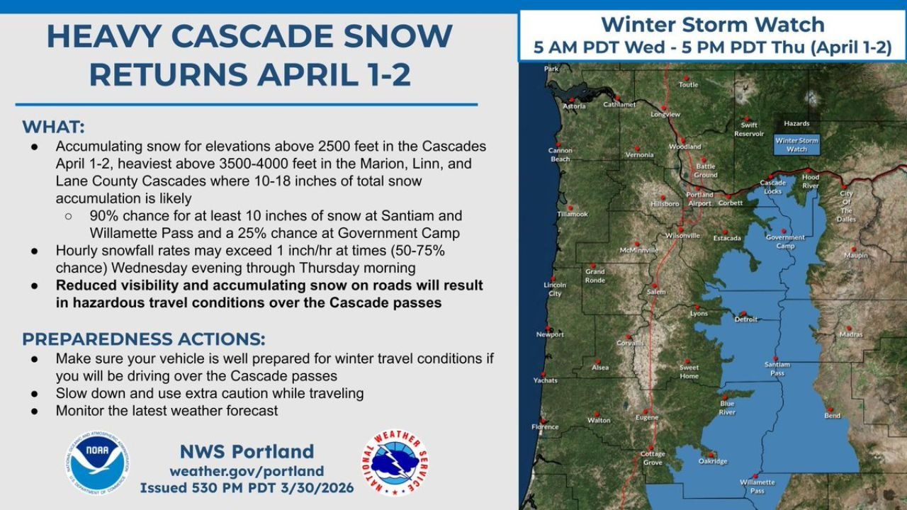
PORTLAND, OREGON — The National Weather Service Portland has issued a Winter Storm Watch for the Oregon Cascades from 5 AM PDT Wednesday April 1 through 5 PM PDT Thursday April 2, with 10 to 18 inches of snow expected above 3,500 to 4,000 feet elevation across the Marion, Linn and Lane County Cascades. Snow will begin accumulating above 2,500 feet as the system moves in, with the heaviest totals concentrated at higher elevations. Santiam Pass has a 90% chance of receiving at least 10 inches of snow, while Government Camp carries a 25% chance of significant accumulation. Hourly snowfall rates may exceed 1 inch per hour at times — with a 50 to 75% probability of those rates occurring from Wednesday evening through Thursday morning — creating rapidly deteriorating and hazardous travel conditions across all Cascade mountain passes.
Where the Heaviest Snow Will Fall
The NWS Portland forecast breaks down the snow accumulation picture clearly for the Oregon Cascades:
Highest snow totals — 10 to 18 inches likely:
- Santiam Pass — 90% chance of at least 10 inches, potentially reaching the top of the 10 to 18 inch range
- Willamette Pass — 90% chance of at least 10 inches of accumulation
- Marion County Cascades — in the heart of the heaviest snow zone above 3,500 to 4,000 feet
- Linn County Cascades — heavy accumulation expected across this central Oregon Cascades corridor
- Lane County Cascades — southern portion of the heavy snow zone, including areas near Oakridge and the Willamette Pass corridor
Lower but still significant accumulation:
- Government Camp — 25% chance of significant accumulation, lighter totals more likely but not guaranteed
- Hood River area — within the broader Winter Storm Watch zone on the eastern slopes
- Elevations above 2,500 feet broadly — accumulating snow beginning as the system arrives Wednesday morning
What This Storm Means for Cascade Pass Travel
The most immediate and practical impact of this storm for Oregon residents and travelers is the hazardous travel conditions across the Cascade passes from Wednesday evening through Thursday. The combination of heavy snowfall rates exceeding 1 inch per hour and accumulating snow on roads will create conditions that even experienced winter drivers find challenging.
Highway 20 through Santiam Pass — one of the primary east-west routes connecting the Willamette Valley to Bend and Central Oregon — will be directly in the path of the heaviest snow. Travel over this pass Wednesday evening and into Thursday morning could become extremely difficult or potentially impossible for vehicles without chains or adequate winter tires.
Highway 58 through Willamette Pass — connecting Eugene and the southern Willamette Valley to Chemult and US-97 — also sits in the 90% chance of 10+ inch accumulation zone. Travelers planning to cross this pass during the storm window should either travel before the storm arrives Wednesday morning or wait until Thursday afternoon when conditions are expected to improve.
US-26 through Government Camp — while carrying a lower probability of significant accumulation at 25%, the pass can still see hazardous conditions even with lighter snow totals when rates are high. Winter preparedness is still recommended for any travel over this route Wednesday evening.
Preparedness Actions for Oregon Residents and Travelers
The NWS Portland is issuing clear preparedness guidance for anyone who may be traveling over the Cascade passes during the April 1 to 2 storm window:
- Ensure your vehicle is well prepared for winter travel before attempting to cross any Cascade pass during the storm — chains, good tires and emergency supplies are essential
- Slow down and use extra caution — even if your vehicle is equipped for winter travel, 1 inch per hour snowfall rates reduce visibility and create slippery surfaces very rapidly
- Monitor the latest weather forecast at weather.gov/portland for updated pass conditions and road closure information
- Consider delaying travel — if your trip over the Cascades can wait until Thursday afternoon or Friday when conditions are expected to improve, that is the safest option
Timing — When the Storm Hits Hardest
- Wednesday morning April 1 — snow begins accumulating above 2,500 feet as the system arrives
- Wednesday evening — the most intense snowfall period begins, with rates potentially exceeding 1 inch per hour across Santiam Pass and Willamette Pass
- Wednesday night into Thursday morning — the most dangerous travel window across all Cascade passes
- Thursday afternoon — conditions gradually improve as the storm system exits and the Winter Storm Watch expires at 5 PM PDT
What to Watch Next
- Pass condition updates from ODOT — Oregon Department of Transportation road condition reports for Highway 20, Highway 58 and US-26
- NWS Portland updates at weather.gov/portland for any changes to the Winter Storm Watch area or snow accumulation forecasts
- Snowfall rate intensity Wednesday evening — whether the 50 to 75% chance of 1 inch per hour rates materializes and how long those intense rates last
- Government Camp accumulation — whether the 25% chance of significant snow there trends higher or lower as the storm approaches
- Lower elevation impacts — whether snow levels drop below 2,500 feet during the most intense phase of the storm, potentially affecting communities in the Cascade foothills
Residents and travelers planning trips across the Oregon Cascade passes on Wednesday April 1 or Thursday April 2 should treat this Winter Storm Watch seriously and be fully prepared for winter driving conditions before departing.
WaldronNews.com will continue tracking the Oregon Cascades Winter Storm Watch and provide updated snowfall totals and pass condition information as the April 1 to 2 storm system develops.