
Pacific Northwest Faces Another Westerly Wind Surge Friday Evening, Though Models Show Less Intensity Than Prior Event
WASHINGTON, OREGON, AND IDAHO — Another round of strong westerly winds is expected to move into parts of the Pacific Northwest Friday evening as a familiar storm pattern returns, though meteorologists say this surge appears weaker than the powerful wind event that impacted the region the night before.
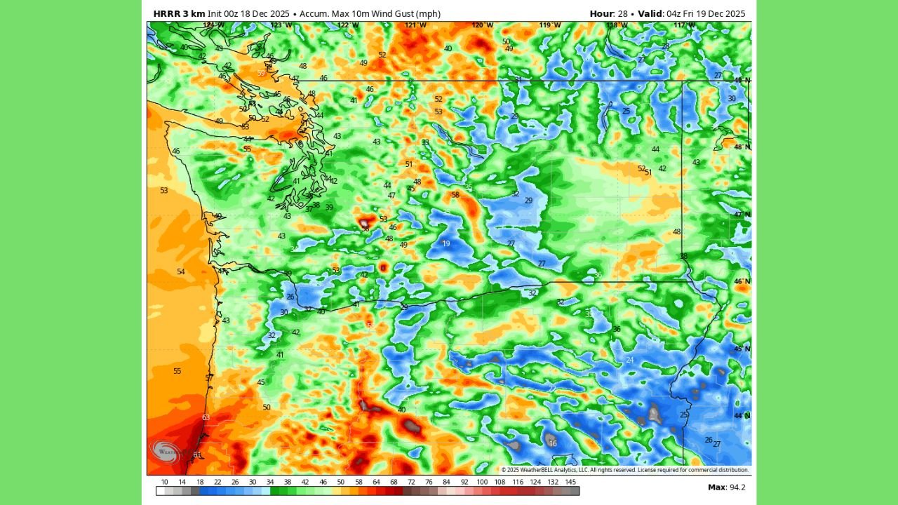
High-resolution HRRR model guidance shows a renewed push of onshore flow developing late Friday, with gusty conditions increasing between roughly 4 p.m. and 6 p.m. local time. While the setup closely resembles the previous system in terms of placement and structure, current projections suggest lower peak wind speeds overall.
What the Latest HRRR Data Shows
The HRRR 3-kilometer model indicates another burst of enhanced winds spreading inland from the Pacific Ocean, particularly affecting coastal areas, higher terrain, and exposed gaps and ridges across western Washington and Oregon.
While the color-shaded wind gust output still highlights pockets of 50–70 mph gusts in favored terrain, the coverage and intensity are less expansive than what was observed during the stronger surge earlier in the week.
Model output shows:
- Strongest winds focused in higher elevations and wind-prone corridors
- Lower gust potential in valley and urban areas
- A shorter-lived event compared to the prior night’s surge
How This Event Compares to the Previous Surge
Meteorologists tracking this pattern note that the low-pressure placement and westerly trajectory are nearly identical to the earlier event, but subtle differences in strength are limiting the impact.
Key differences include:
- A weaker pressure gradient
- Less momentum transfer inland
- Reduced potential for widespread damaging gusts
Because of this, the incoming surge is expected to “pack less of a punch,” especially away from exposed ridgelines and coastal headlands.
Timing and Areas Most Likely to See Impacts
Current model timing places the onset of stronger winds during the late afternoon into early evening hours Friday, with the peak window centered around 4–6 p.m. before gradually easing overnight.
Areas most likely to notice gusty conditions include:
- Coastal headlands
- Mountain passes
- East-west oriented valleys
- Locations that experienced strong winds during previous westerly events
Lower-elevation urban areas may still experience breezy conditions, but widespread damage is not currently indicated.
Why Forecasters Are Still Monitoring the System
Despite the reduced intensity shown so far, forecasters emphasize that additional model runs will be crucial in confirming the final strength and coverage of the wind field.
Small changes in:
- Low-pressure strength
- Jet positioning
- Boundary-layer mixing
could still result in locally stronger gusts, particularly in terrain-enhanced zones.
What Residents Should Do
While this does not appear to be a repeat of the strongest recent wind event, residents are still encouraged to:
- Secure loose outdoor items
- Use caution in high-profile vehicles
- Stay aware of updated forecasts Friday
WaldronNews.com will continue monitoring incoming model data and provide updates if wind intensity or timing changes as the event approaches.