
Pacific Northwest Faces Prolonged Heavy Rain: Up to 8 Inches Expected in Washington and Oregon Through Mid-Month
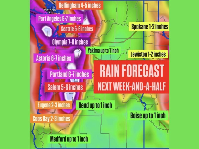
Portland, Oregon — The Pacific Northwest is gearing up for an extended stretch of heavy rainfall as an active weather pattern sets in through the middle of the month. Meteorologists warn that a series of storm systems will funnel Pacific moisture directly into Washington and Oregon, leading to widespread rain totals of 5 to 8 inches in some areas — and raising concerns for localized flooding.
Widespread Heavy Rain Along the Coast and I-5 Corridor
Forecast models show consistent rain bands taking aim at coastal and western interior regions of Washington and Oregon starting late this week. The heaviest rainfall is expected between Seattle, Olympia, and Portland, where total accumulations could reach 6 to 8 inches by mid-month.
Cities along the coast such as Astoria, Coos Bay, and Port Angeles could see 6 to 7 inches of rainfall, while Olympia may see as much as 7 to 8 inches before the pattern eases.
Meanwhile, Bellingham is expected to pick up around 4 to 5 inches, and Eugene could see 2 to 3 inches, depending on the storm track.
Inland Areas to See Moderate Rainfall
Farther inland, rainfall totals will be lower but still steady. Yakima, Bend, and Medford should see around an inch of rain, while eastern regions such as Spokane and Lewiston are forecast to receive 1–2 inches.
Though these amounts are less significant than coastal totals, forecasters caution that melting snow and saturated soils in these regions could still lead to minor flooding in valleys and low-lying areas.
Flooding Concerns Grow as Pattern Persists
Meteorologists say the repeated storm cycles could create flooding risks across western Washington and Oregon as saturated soils struggle to absorb additional rainfall. Urban areas along the Interstate 5 corridor will need to monitor for standing water, slick roads, and clogged drainage systems.
Mountain regions — including the Cascades — will also see heavy precipitation, falling as rain at lower elevations and snow at higher peaks, further increasing runoff potential.
Travel and Safety Advice
Drivers across the Pacific Northwest should expect wet commutes, reduced visibility, and possible travel delays on mountain passes and coastal highways. Authorities advise residents to clear storm drains, avoid flooded roadways, and stay tuned for any flood advisories or river warnings that may be issued in the coming days.
The pattern shows no immediate signs of breaking down, with meteorologists projecting continued wet conditions well into the second half of December.
For ongoing updates and weather alerts across the Pacific Northwest, follow WaldronNews.com for verified coverage and local impact reports.