
Pacific Northwest Storm to Bring Rain, Freezing Rain, and Snow Across Washington and Oregon Thursday
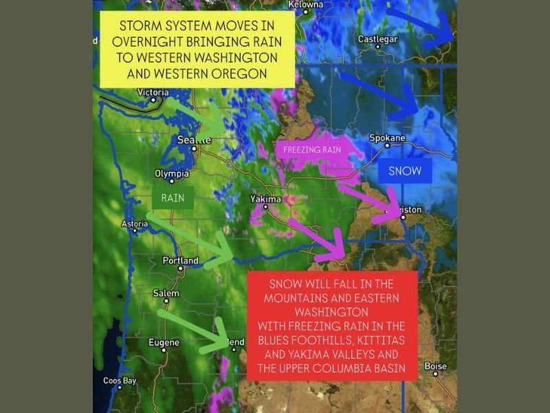
Seattle, Washington — The Pacific Northwest is gearing up for another active weather day as a new storm system moves inland overnight, bringing a messy mix of rain, freezing rain, and snow across multiple regions by Thursday morning. The system, the first in a series expected to impact the area through the weekend, will make the morning commute especially hazardous across both Washington and Oregon.
Heavy Rain Targets Western Washington and Oregon
Rain will begin late Wednesday evening along the Pacific coast and quickly spread inland. The heaviest precipitation is expected in western Washington, including Seattle, Olympia, and Tacoma, extending southward into Portland, Salem, and Eugene, Oregon.
Commuters on Interstate 5 should prepare for steady rain and occasional downpours through the Thursday morning rush hour. While flooding is not a major concern at this stage, ponding on roadways and reduced visibility will slow travel across the region.
Freezing Rain Threatens Central Washington
As the storm crosses the Cascade Mountains, colder air trapped in the valleys will set the stage for freezing rain in central Washington, particularly in the Kittitas, Yakima, and Blues foothills. This area will see some of the most dangerous travel conditions, as light freezing rain could create slick roads, icy bridges, and hazardous driving surfaces before transitioning to snow later in the morning.
Residents in Yakima, Ellensburg, and the Upper Columbia Basin are urged to use caution if traveling early, as untreated roads could become icy quickly.
Snow to Blanket the Mountains and Eastern Washington
Farther east, the cold side of the system will deliver snowfall to the mountains and eastern Washington, including the Spokane and Lewiston areas. Snow accumulations will vary, but moderate to heavy bursts are possible in higher elevations, adding to the region’s early-winter snowpack.
Travel across the Cascade passes is also expected to be treacherous overnight, with both Snoqualmie Pass and Stevens Pass likely to see a combination of snow and freezing rain during the peak of the storm.
Morning Commute to Be Slow and Slippery
The National Weather Service warns that the combination of rain, ice, and snow could make for a challenging Thursday morning commute across much of Washington and Oregon. Drivers are urged to leave early, reduce speeds, and allow extra time to reach their destinations.
While western Washington will deal mainly with rain, central and eastern areas are expected to experience wintry precipitation well into mid-morning before conditions gradually improve by afternoon.
Stay tuned to WaldronNews.com for continued updates on this evolving Pacific Northwest storm and other weather alerts across the region.