
Pacific Ocean and Gulf of Mexico Data Gap Creates Forecast Uncertainty as Ongoing Dropsonde Mission Delays Full U.S. Model Alignment
UNITED STATES — A critical weather reconnaissance mission is underway over the Pacific Ocean, while a completed dropsonde mission over the Gulf of Mexico has already fed fresh atmospheric data into major U.S. forecast models. The staggered data availability is creating short-term forecast differences between models and could significantly affect how upcoming storm systems are handled over the central and eastern United States.
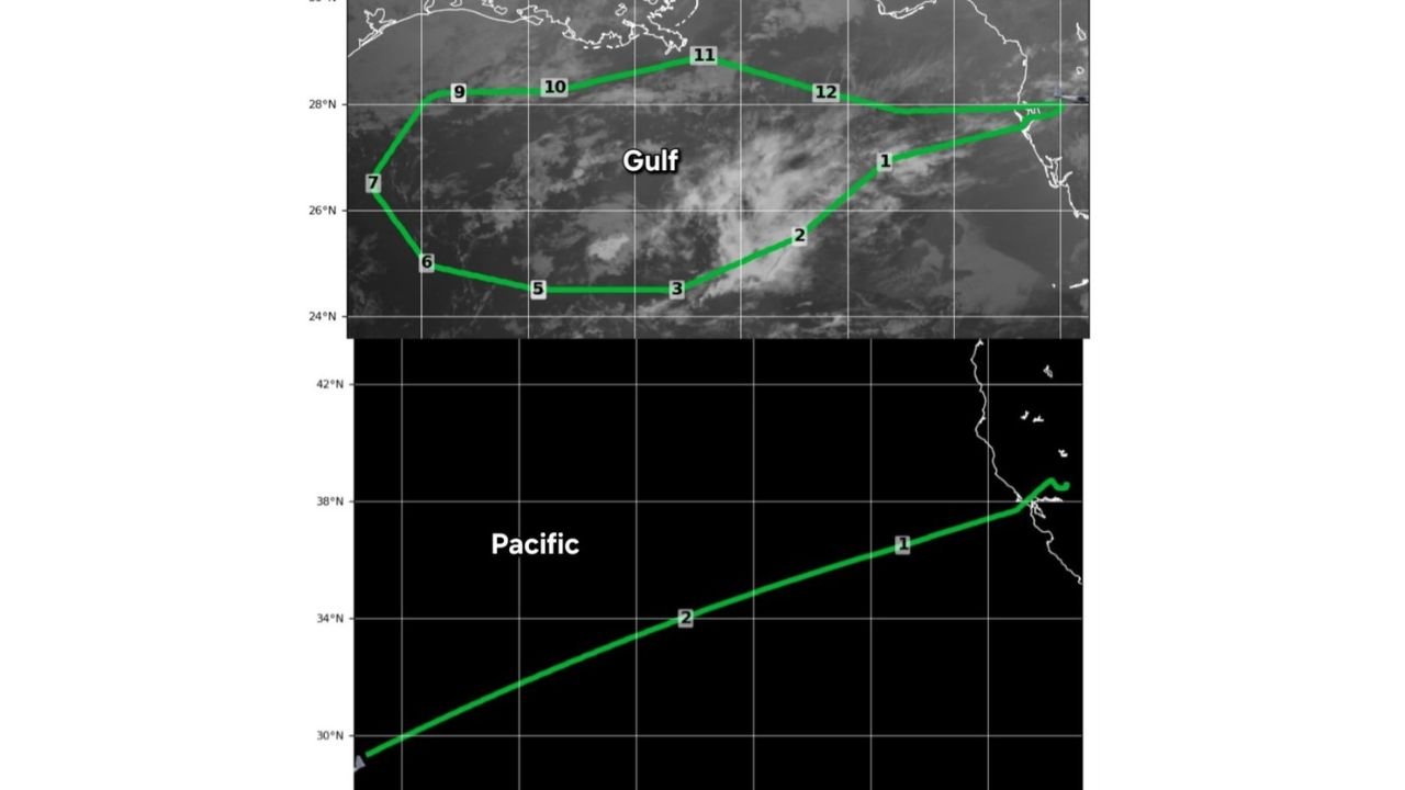
What the Dropsonde Missions Are Measuring
Dropsondes are deployed from high-altitude aircraft to collect real-time vertical profiles of the atmosphere, including temperature, humidity, wind speed, and pressure from flight level down to the ocean surface. These measurements are especially valuable over ocean regions where routine observations are limited.
The Gulf of Mexico mission completed a full loop of dropsonde releases, while the Pacific mission remains ongoing, meaning not all models are currently working with the same upstream data.
Current Model Data Intake Status
As of the latest update, model data ingestion is uneven, depending on which region the model emphasizes:
- NAM (North American Mesoscale): Ingested the first two Gulf dropsondes
- GFS (Global Forecast System): Successfully ingested all 12 Gulf dropsondes
- ECMWF (Euro): Expected to ingest all 12 Gulf dropsondes plus the full Pacific mission
- GEM (Canadian): Received 12 Gulf dropsondes and a limited number from the Pacific
Because the Pacific mission is still in progress, U.S.-based models are currently missing part of the upstream energy and moisture signal that often drives major North American weather systems.
Why the Pacific Data Matters So Much
The Pacific Ocean is the primary source region for long-wave troughs, jet streaks, and moisture plumes that eventually impact the western, central, and eastern United States. Until full Pacific dropsonde data is ingested:
- Storm strength may be under- or over-estimated
- Track differences between models are more likely
- Timing of precipitation and frontal passages may shift
- Downstream impacts such as snow, ice, or severe weather remain uncertain
Once the Pacific mission data is fully assimilated, models—especially the Euro—often snap into better agreement.
Short-Term Forecast Confidence: What to Expect
Over the next 12–24 hours, forecast confidence may fluctuate as models update with additional reconnaissance data. This is a normal but critical phase in high-impact weather forecasting.
Key takeaways for forecasters and the public:
- Expect model-to-model volatility until Pacific data is complete
- Later model runs are likely more reliable than earlier ones
- Confidence should increase rapidly once all dropsonde data is assimilated
What Happens Next
The completion of the Pacific dropsonde mission will allow global models to fully resolve upstream atmospheric features. This typically results in:
- Improved storm track clarity
- More accurate intensity forecasts
- Better agreement on timing and impacts
Until then, short-range forecasts should be viewed as preliminary, with updates expected as new data enters the system.
Residents across weather-sensitive regions should stay alert for forecast refinements, especially if upcoming systems involve heavy precipitation, winter weather, or strong winds.
For continued updates and detailed weather analysis, follow ongoing coverage on Waldron’s weather desk.