
Pacific Ocean, Gulf of Mexico, and United States Forecasts Diverge as NAM Receives Only 2 Dropsondes While GFS Ingests All 12 for 00Z Runs
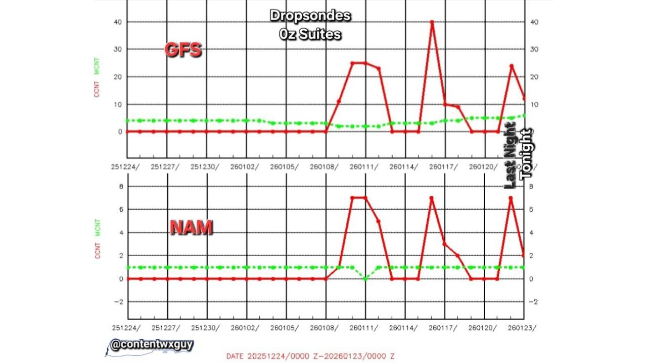
UNITED STATES — New dropsonde ingestion data from the latest 00Z model suites shows a clear imbalance in how upstream atmospheric observations were absorbed by major forecast models overnight, setting the stage for short-term forecast uncertainty across the United States. While the GFS successfully ingested all 12 dropsondes, the NAM captured only two, leaving notable gaps in how each model is resolving incoming weather energy from the Pacific and Gulf regions.
Dropsonde Ingestion Snapshot From the 00Z Runs
Analysis of the dropsonde charts highlights a sharp contrast between the two primary U.S. models:
- GFS: Fully ingested 12 dropsondes for the 00Z cycle
- NAM: Ingested only 2 dropsondes during the same window
The red spikes on the charts indicate successful dropsonde assimilation, while flat periods confirm missing data. This discrepancy is especially important given the ongoing Pacific reconnaissance mission and the recently completed Gulf of Mexico sampling loop.
Why This Data Gap Matters for the U.S. Forecast
Dropsondes provide critical vertical data in data-sparse ocean regions, helping models accurately initialize:
- Jet stream position and strength
- Moisture transport
- Shortwave timing
- Surface pressure evolution
With the NAM missing the majority of the dropsonde package, it is likely underrepresenting upstream forcing, which can lead to:
- Weaker or delayed storm development
- Timing errors in precipitation onset
- Track differences compared to global guidance
Meanwhile, the GFS, having ingested the full dataset, is better positioned to resolve near-term evolution of large-scale features.
Pacific Influence Still a Key Wildcard
The dropsonde missions show that Pacific data collection is still ongoing, meaning even the GFS solution may continue to evolve as additional observations are assimilated in later cycles. Historically, once Pacific dropsonde data fully enters the global models, forecast consistency improves markedly within 12–24 hours.
Until then:
- Run-to-run volatility is expected
- NAM solutions should be treated cautiously
- Later GFS and Euro cycles will likely trend toward a more stable outcome
What to Watch Going Forward
Forecasters will be closely monitoring:
- Completion of the Pacific dropsonde mission
- Data ingestion in upcoming 06Z and 12Z cycles
- Convergence between GFS, Euro, and Canadian guidance
As more observational data enters the system, confidence in storm timing, strength, and downstream impacts across the United States should steadily increase.
For now, forecast differences are not a model failure—but a reflection of uneven real-world data availability feeding the guidance.
Stay tuned to Waldron’s weather coverage as models adjust and confidence improves with each new cycle.