
Pacific Ocean Heat Signal Stronger Than 1997 as West Pacific Warm Pool Builds East of the Dateline, Raising El Niño Questions
UNITED STATES — A strengthening subsurface warm signal east of the international dateline is now measuring stronger than what was observed at the same time in 1997 — the year that went on to produce one of the most powerful El Niño events on record.
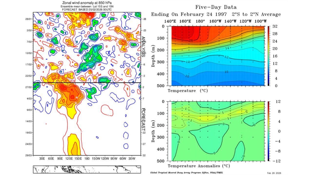
New five-day equatorial Pacific data ending February 24, 2026, shows a pronounced reservoir of above-average water temperatures from roughly 140°E to 120°W, particularly between 50 and 200 meters below the surface.
The structure and magnitude of this warm pool closely resemble — and in some areas exceed — early 1997 conditions.
Subsurface Heat Building East of 160°E
Temperature cross-sections across the equatorial Pacific reveal:
- Deep warm anomalies extending east of the dateline
- Significant positive departures from average between 100–200 meters depth
- A coherent warm pool poised for eastward expansion
Compared to February 1997 data, the 2026 anomaly appears broader and in places stronger east of 160°E.
This matters because subsurface warmth often precedes surface warming during El Niño development.
Westerly Wind Anomalies Emerging
850 hPa zonal wind anomaly charts show developing bursts of westerly wind activity across the western and central Pacific.
Historically, strong westerly wind bursts in late February and March helped trigger the rapid intensification of the 1997 El Niño.
The current wind setup suggests:
- Strengthening westerly anomalies near 130°E–160°E
- Favorable upper-tropospheric background winds
- Conditions supportive of eastward warm water transport
These winds act like a push, helping move warm West Pacific water toward the central and eastern Pacific.
MJO Signal May Stall in Key Region
Forecast data indicates part of the Madden-Julian Oscillation (MJO) signal could linger between 130°E and 160°E over the next several weeks.
When the MJO stalls in this region:
- Westerly wind bursts can strengthen
- Kelvin waves may develop
- Subsurface warmth can surge eastward
This combination increases the likelihood of mass warm water displacement across the Pacific basin.
200mb Wind Composite Supports Pattern
Upper-level 200mb wind composites show enhanced divergence and favorable tropical wind patterns consistent with:
- Sustained Pacific convection
- Continued atmospheric-ocean coupling
- A setup that mirrors early stages of strong El Niño years
The developing West Pacific event appears dynamically supported from both oceanic and atmospheric perspectives.
Why 1997 Is the Benchmark
The 1997 event rapidly intensified after late-winter westerly wind bursts.
At this point in 1997:
- Subsurface warmth was present but slightly less expansive east of the dateline than current readings
- Westerly wind bursts soon amplified dramatically
If 2026 follows a similar trajectory, significant Pacific warming could accelerate during March and April.
What This Could Mean for the United States
While the event is still developing, a strengthening El Niño later this year could eventually influence:
- U.S. hurricane season activity
- Winter storm tracks
- Severe weather patterns
- Temperature anomalies across the Lower 48
For Arkansas and the Southern Plains, strong El Niño years historically correlate with wetter late-fall and winter patterns — though impacts vary by season and intensity.
Bottom Line
The equatorial Pacific is showing a subsurface warm signal east of the dateline that is stronger than at this same time in 1997 — a year that led to one of the strongest El Niño events on record.
With developing westerly wind anomalies and a supportive atmospheric setup between 130°E and 160°E, the stage appears set for potential eastward expansion of warm Pacific waters in the coming weeks.
Whether 2026 ultimately rivals 1997 remains to be seen — but the ocean-atmosphere signals are aligning in a way that has forecasters paying close attention.
Stay with WaldronNews.com for continued updates as Pacific conditions evolve and their potential impacts on U.S. weather become clearer.