
Pacific Ocean Pattern Flips From 2012’s Strong La Niña Cold Phase to 2026’s Warmer Basin — Dramatic Shift in PDO and Global SST Anomalies
UNITED STATES — A side-by-side look at NOAA sea surface temperature (SST) anomaly maps from mid-February 2012 and mid-February 2026 reveals a dramatic shift in Pacific Ocean patterns — highlighting just how different today’s setup is compared to one of the more pronounced cold phases of the last decade.
The 2012 map shows a strongly negative Pacific Decadal Oscillation (PDO) pattern paired with a central-based La Niña. The 2026 map, by contrast, shows a much warmer Pacific basin overall, with widespread above-average temperatures dominating large portions of the ocean.
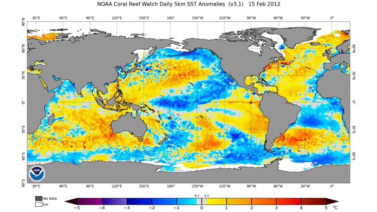
February 2012: Strong Cold Phase Across the Pacific
The NOAA Coral Reef Watch SST anomaly map dated February 15, 2012, shows:
- Broad areas of blue shading (cool anomalies) across the eastern and central Pacific.
- A pronounced cold pool extending westward from the coast of South America.
- Widespread cooler-than-average waters along the West Coast of North America.
- Cooler anomalies across portions of the North Pacific — a classic negative PDO signature.
In 2012, the Pacific basin exhibited a strong cold configuration, particularly across the equatorial region. That central-based La Niña signal reinforced cooler waters stretching across the eastern tropical Pacific.
This type of setup often correlates with:
- Altered jet stream patterns
- Increased storminess in some regions
- Suppressed rainfall in others
- Agricultural impacts across parts of the U.S. Corn Belt
February 2026: A Warmer Pacific Basin Dominates
Fast forward to February 14, 2026, and the ocean looks notably different.
The 2026 anomaly map shows:
- Widespread yellow and orange shading (above-average SSTs) across much of the Pacific.
- A lack of the expansive cold pool that defined 2012.
- Warmer anomalies stretching across large portions of the North Pacific.
- A different configuration along the equatorial Pacific compared to the central-based La Niña of 2012.
Instead of a dominant negative PDO look, the Pacific basin now appears more uniformly warm in many areas — particularly in the North Pacific and western tropical Pacific.
Why the PDO and La Niña Matter
The Pacific Decadal Oscillation (PDO) reflects long-term ocean temperature patterns in the North Pacific. A negative PDO phase — like in 2012 — is typically characterized by:
- Cooler waters along the North American West Coast
- Warmer waters in the western Pacific
In contrast, the 2026 pattern shows warmer anomalies extending farther east, altering the large-scale oceanic background state.
Meanwhile, La Niña — driven by cooler-than-average equatorial Pacific waters — was more clearly defined in 2012 than it appears in 2026’s broader warm-dominant setup.
Implications for U.S. Weather Patterns
While ocean anomalies do not directly dictate day-to-day weather, they strongly influence seasonal trends by:
- Modulating storm tracks
- Influencing jet stream placement
- Affecting drought and precipitation patterns
The 2012 configuration supported a markedly different atmospheric regime than what forecasters are working with today.
In agricultural regions — particularly the Midwest Corn Belt — Pacific background states can influence spring planting conditions and summer rainfall patterns.
A Basin-Wide Contrast
The contrast between February 2012 and February 2026 highlights how dynamic ocean patterns can be from one decade to the next.
Where 2012 featured:
- A strongly negative PDO
- A defined cold La Niña footprint
- Extensive cool anomalies across the Pacific
The 2026 snapshot shows:
- Much more widespread warm anomalies
- A less dominant cold equatorial signal
- A Pacific basin that looks fundamentally different from 14 years ago
Ocean temperatures set the stage for long-term climate tendencies. And right now, the Pacific Ocean’s background state bears little resemblance to what was in place in early 2012.
WaldronNews.com will continue tracking oceanic trends and their potential influence on upcoming seasonal weather patterns.