
Pennsylvania Braces for Sunday Severe Storm Risk From Pittsburgh to Harrisburg and Allentown as Cold Front Targets Areas South of I-80
HARRISBURG, PA — A cold front sweeping into Pennsylvania Sunday afternoon and evening is expected to trigger a low-end but notable severe weather risk across much of the state — especially along and south of the Interstate 80 corridor.
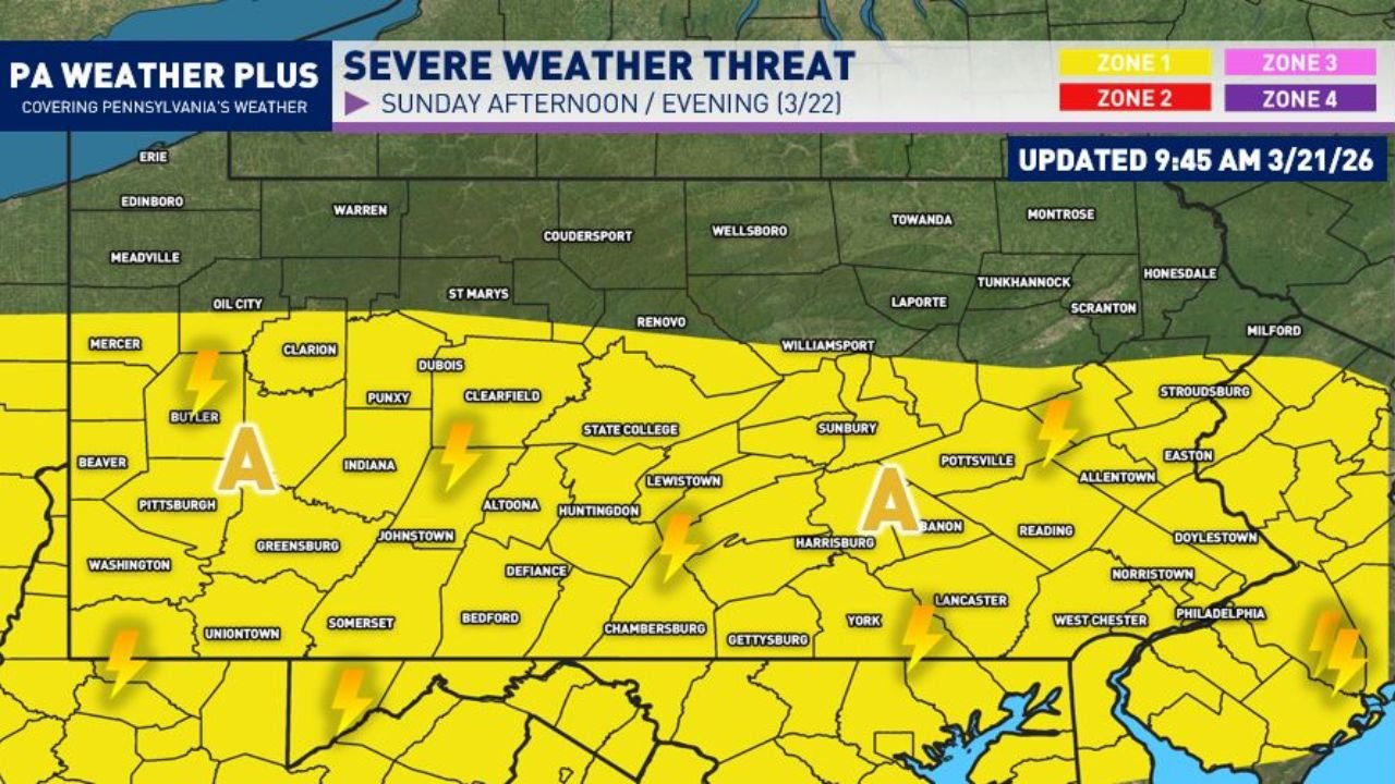
Forecasters indicate the greatest overlap of atmospheric instability and wind shear will focus across central and southern Pennsylvania, increasing the chance for isolated strong to severe thunderstorms.
Timing: Storms Fire Mid-Afternoon
The most favorable window for storm development is between 2 PM and 4 PM Sunday, with storms expected to track generally south-southeast into the late afternoon and evening hours.
Communities across:
- Pittsburgh
- Butler
- Indiana
- State College
- Altoona
- Harrisburg
- Lebanon
- York
- Lancaster
- Reading
- Allentown
- Philadelphia
are all included within the primary risk zone.
Far southern Pennsylvania may not see storm impacts until closer to sunset as the line continues to progress.
Who Is in the Risk Area?
The highlighted “Area A” zone spans much of:
- Western Pennsylvania, including the Pittsburgh metro
- Central Pennsylvania, including State College and Harrisburg
- Eastern Pennsylvania, including the Lehigh Valley and portions of the Philadelphia metro
This area is currently categorized under a lower-end severe risk, but forecasters caution that an upgrade to a Zone 2 (Scattered) risk may be needed depending on how conditions evolve.
Primary Threats: Gusty Winds and Hail
The strongest thunderstorms could produce:
- Wind gusts between 45 and 55 mph
- Isolated hail up to quarter size
- Frequent lightning
- Brief heavy downpours
While widespread severe weather is not expected, isolated pockets of stronger storms may briefly intensify.
Why South of I-80?
The reasoning centers on where instability and wind shear overlap most effectively. Areas along and south of I-80 are forecast to see:
- Better surface heating
- Higher moisture levels
- Stronger wind energy aloft
Wind shear — the change in wind speed or direction with height — plays a crucial role in organizing storms and allowing them to strengthen.
Not Every Community Will See Severe Weather
Forecasters emphasize that severe storms are often localized. Even within the risk zone, some neighborhoods may experience only brief rain while others see stronger wind gusts or hail.
This is not expected to be a large-scale outbreak, but preparedness remains important.
Residents are encouraged to:
- Monitor updated forecasts
- Ensure multiple ways to receive weather alerts
- Identify a safe indoor shelter location in case warnings are issued
Looking Ahead
As of the latest update Sunday morning, the severe risk remains low-end but real across western, central, and eastern Pennsylvania.
Storm coverage and intensity will depend on how quickly the atmosphere destabilizes during the afternoon hours.
Stay with WaldronNews.com for continuing updates as Sunday’s severe weather threat develops across Pennsylvania.