
Pennsylvania Clipper Brings Friday Snow Chances, Then 50–60 MPH Wind Gusts and Dangerous Wind Chills This Weekend
PENNSYLVANIA — Another active stretch of winter weather is lining up as a clipper system moves into the state Friday, bringing light snow for parts of western and central Pennsylvania before the focus shifts east overnight. While many spots won’t see a major accumulation, the bigger headline comes after the snow: strong wind gusts Saturday and a brutal Arctic blast this weekend, with dangerous wind chills developing late Friday night into Saturday morning.
Friday’s setup: a clipper slides west-to-east
Forecast guidance in the graphic points to a clipper arriving first across western and central Pennsylvania during the day Friday, then pushing east through the overnight hours. That means some areas may see snow on and off during daylight, while others have a better chance late Friday night into early Saturday.
Temperatures are still cold, but “not as cold” compared to recent bitter stretches—many locations top out in the 20s, with a few southeastern spots flirting with near 30°F.
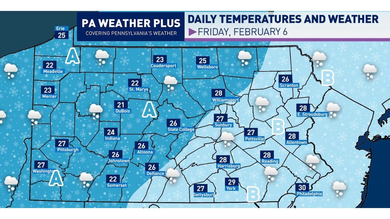
Friday high temperature snapshots shown on the map include:
- Pittsburgh 27°F, Washington 27°F
- Erie 25°F, Meadville 22°F, Mercer 23°F
- DuBois 21°F, St. Marys 22°F
- State College 26°F, Altoona 26°F, Johnstown 26°F
- Harrisburg 28°F, York 29°F, Reading 28°F
- Allentown 28°F, Scranton 26°F, Philadelphia 30°F
Area A: light snow most likely in western and parts of central Pennsylvania
The forecast breakdown labels Area A as the zone with the best chance for light snow arriving in the morning and early afternoon. The note also emphasizes that western Pennsylvania is favored, with snow becoming more scattered toward parts of central Pennsylvania because of drier air trying to cut into the system.
What that means in real terms: towns west of the mountains could see steadier light snow at times, while central areas may see breaks, lighter coverage, or less consistent intensity.
Area B: flurries in the afternoon, then better overnight snow shower chances
The map labels Area B farther east, where the expectation is more limited during the day: flurries or a passing light snow shower Friday afternoon. However, the guidance says the better chance for snow showers arrives overnight Friday into Saturday morning, as the system continues sliding east.
Eastern Pennsylvania should watch that overnight window closely—especially for quick coatings on untreated roads and bridges heading into early Saturday.
Western Pennsylvania could see snow squalls Friday evening (7–11 PM)
One of the more important notes in the forecast is the mention of snow squalls being possible across western Pennsylvania during the evening hours (roughly 7 PM to 11 PM).
Snow squalls are dangerous not because they always drop huge totals, but because they can:
- Flash-cover roads in minutes
- Create sudden whiteouts
- Cause quick spin-outs on highways, especially if the pavement temperature is low
If you’re traveling around the Pittsburgh region, I-79, I-70, I-76, or other major corridors Friday evening, this is the period to be extra alert for rapid changes.
Strong wind gusts ramp up Saturday
The wind graphic highlights widespread strong gusts Saturday (morning through evening), with many areas indicated at 40 to 50 mph, and a few corridors pushing 50 to 60 mph.
What to expect from winds like that:
- Blowing snow in open areas (even with lighter totals)
- Difficult travel for high-profile vehicles
- Isolated power issues possible, especially where gusts peak
Frigid weekend: Arctic air arrives Saturday and Sunday
After the clipper, the forecast messaging turns sharply colder: a strong blast of Arctic air moves in for Saturday and Sunday, bringing very cold temperatures and gusty winds.
The key point in the write-up is that this weekend could feel worse than the prior cold stretch because stronger winds can create longer-lasting, harsher wind chill conditions, and the cold may hold firm with high temperatures staying suppressed.
Wind chills turn dangerous late Friday night into Saturday morning
The wind chill map shows a serious plunge for many parts of Pennsylvania late Friday night into Saturday morning.
Approximate wind chill ranges shown:
- -30°F to -35°F in parts of northern and interior Pennsylvania
- -20°F to -30°F across a large portion of the state
- -10°F to -15°F across parts of southern Pennsylvania
- Near 0°F closer to the far southeastern corner at times
The forecast also notes there may be little improvement Saturday afternoon, before wind chills drop again Saturday night into Sunday morning.
What residents should do now
Even when snowfall is light, wind + Arctic air can create bigger real-world problems than totals alone.
Quick prep checklist:
- If you’re driving Friday night, keep extra time for sudden squalls in western PA
- Secure loose outdoor items before Saturday’s strong gusts
- Limit prolonged outdoor exposure this weekend, especially kids and pets
- Dress for wind chills (face/hand protection matters most in subzero wind chill)
If you’re in Pennsylvania, what are you seeing so far—flurries, light snow, or quiet skies? Drop your local update and keep following weather coverage on WaldronNews.com.