
Pennsylvania, Maryland, Virginia and Washington, D.C. Could Surge Into the 60s and 70s as Powerful Early-March Warm Pattern Builds — Coastal New York and Massachusetts May Stay Cooler
UNITED STATES — Forecast models are increasingly aligning around a notable warm-up heading into early March, with strong signals pointing toward well above-normal temperatures across the Mid-Atlantic and much of the eastern United States.
Multi-model ensemble guidance suggests that cities such as Washington, D.C., Philadelphia, and Baltimore could see highs pushing into the 60s and even low 70s late next week, marking a dramatic shift from recent late-winter chill.
But while the interior Mid-Atlantic may fully tap into this springlike surge, the immediate Northeast coastline — including New York City and Boston — may not feel the full impact.
Strong Upper-Level Ridge Supports Widespread Warmth
The 500mb height anomaly map (Days 5–12) shows a robust upper-level ridge expanding across the eastern half of the United States.
Deep red shading stretches from:
- The Ohio Valley
- Through the Mid-Atlantic
- Into parts of the Northeast
- Southward across the Carolinas and Georgia
This ridge placement supports sinking air, increased sunshine, and warmer surface temperatures. The strength and geographic spread of the ridge signal that this is more than just a one-day spike — it represents a broader pattern shift.
Meanwhile, cooler troughing is indicated across the western U.S., helping reinforce the warm ridge downstream.
850mb Temperatures Confirm the Warm Signal
At roughly 5,000 feet above ground level (850mb), temperature anomaly maps show pronounced positive departures centered over:
- Pennsylvania
- Maryland
- Virginia
- West Virginia
- The broader Mid-Atlantic and Ohio Valley
This mid-level warmth strongly correlates with above-normal surface temperatures when mixing conditions are favorable.
The consistency between the upper-level ridge and 850mb warmth adds confidence that interior locations will see a meaningful warm-up rather than a brief, shallow spike.
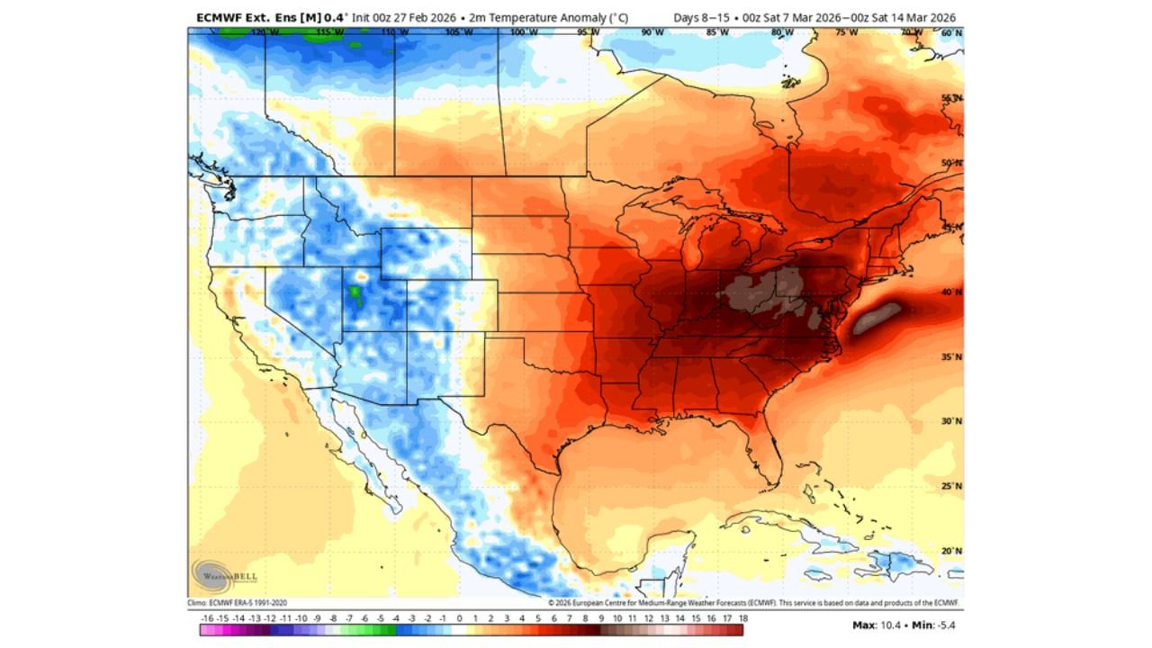
Surface Temperatures: 10°+ Above Normal in Spots
The 2-meter temperature anomaly forecast (Days 8–15) highlights widespread positive anomalies across the eastern U.S., with some areas running 8 to 12 degrees above normal.
The warmest anomalies appear concentrated from:
- The Mid-Atlantic
- Through the Ohio Valley
- Into portions of the Southeast
Under full sunshine and favorable winds, this setup could easily translate to:
- Upper 60s across inland Maryland and Virginia
- Low 70s possible in southern Mid-Atlantic locations
- Springlike afternoons in Philadelphia and D.C.
The Coastal Wildcard: Backdoor Front Risk
Despite strong warm signals aloft, there is an important caveat for coastal areas.
Model discussion highlights the possibility of a maritime influence, especially for:
- New York City
- Boston
- Immediate coastal New Jersey and New England communities
Persistent easterly or northeasterly winds off the Atlantic can introduce cooler marine air, creating what meteorologists call a “backdoor front.”
These shallow cool air masses slide in from the northeast and can sharply reduce temperatures along the immediate coastline, even while inland areas remain significantly warmer.
Such setups are common in March and become even more frequent in April and May. They often produce sharp temperature contrasts over relatively short distances — sometimes 10–20 degrees between inland and coastal zones.
What This Means Going Into March
If current trends hold:
- Interior Mid-Atlantic and inland Northeast: Springlike warmth likely, with highs in the 60s and possibly low 70s.
- Immediate coastal Northeast: Above normal, but cooler and breezier due to ocean influence.
For areas west of the Appalachians and across the Midwest, temperatures also trend above normal, though the most pronounced warmth centers over the Mid-Atlantic region.
The pattern signals a strong start to March with a legitimate taste of spring — though coastal communities should watch for any last-minute backdoor front intrusions.
Stay with WaldronNews.com for continued weather updates as this warm pattern takes shape and we track exactly how far north and east the spring surge pushes.