
Pennsylvania, New Jersey, and New York May Miss a Big Weekend Storm as Key Upper-Air Pieces Fail to Merge
PENNSYLVANIA – The reason weather talk is “pretty quiet” this morning is showing up at 500mb: the weekend pattern doesn’t come together in time, and even when it tries, it’s not an ideal setup for a major East Coast storm. Instead of phasing into one stronger system, the energy looks split—with the southern piece sliding out to sea before the northern piece can catch it, leaving much of the eastern U.S. with a late offshore phase and a “nothing burger” result.
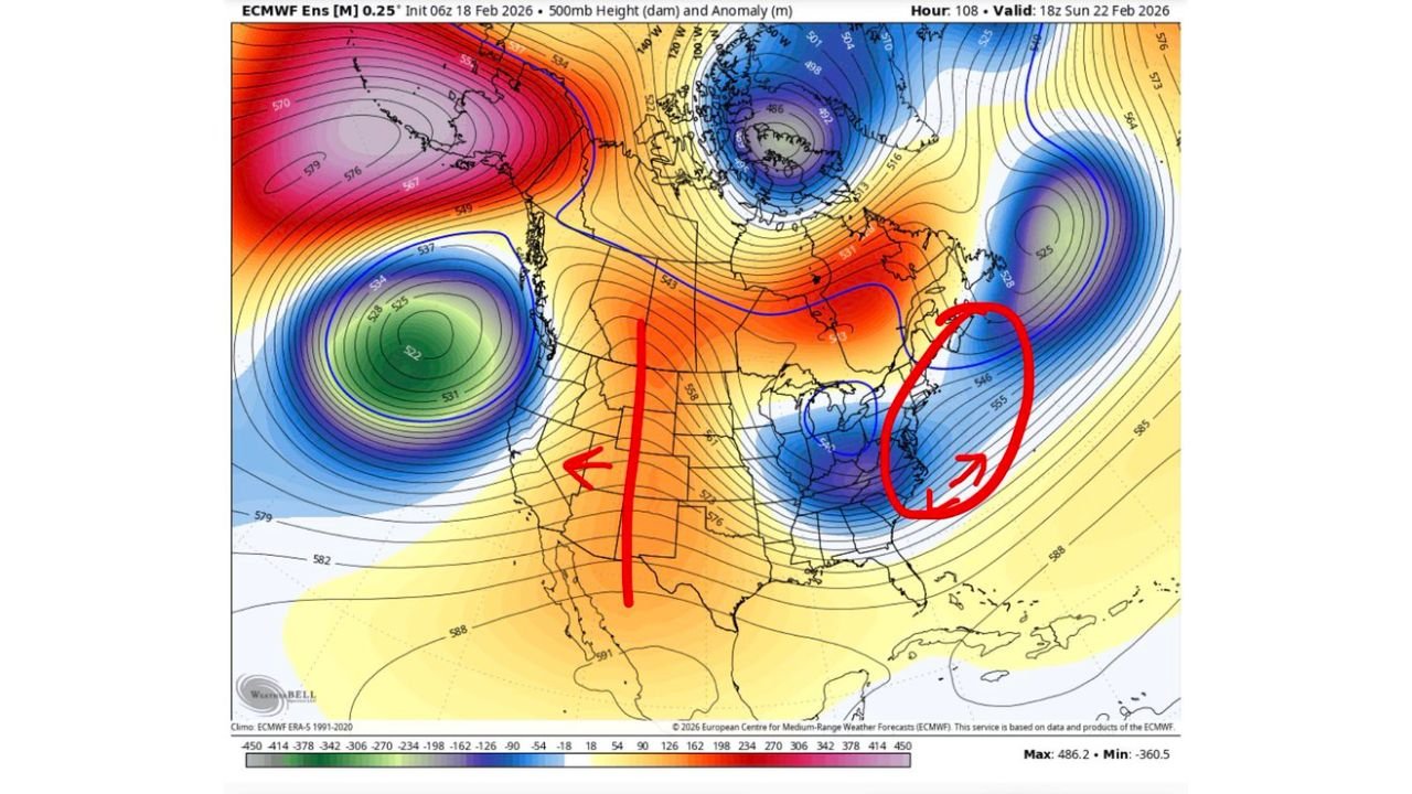
What The 500mb Pattern Is Showing
The 500mb setup (ECMWF ensemble view valid Sunday, Feb. 22) highlights two big problems for storm lovers in the Mid-Atlantic and Northeast:
- The ridge over the Rockies is a bit too far east, which changes how the jet stream energy lines up across the country.
- That shift causes more interaction with the “50/50 low” (a semi-persistent low near Atlantic Canada) instead of a clean, well-timed merger closer to the East Coast.
When that happens, the atmosphere tends to shear and separate the ingredients rather than stack them into one organized storm that can deepen near the coast.
The “50/50 Low” Problem: Why It Matters For The East
A big player here is the 50/50 low sitting near Atlantic Canada (roughly around the Newfoundland/Labrador region on many setups). In this pattern, it’s positioned in a way that can:
- Suppress the storm track, nudging development farther offshore
- Encourage a later, weaker coastal phase, rather than a powerful storm forming close enough to deliver widespread impacts inland
So even if you see pieces of energy trying to move east, the surrounding flow favors pushing the best dynamics out over the Atlantic instead of pulling everything together over the Mid-Atlantic coastline.
Split Energy: Southern Piece Escapes Before The Northern Piece Arrives
The second graphic (500 hPa height + cyclonic vorticity) is a classic visual of why a bigger storm doesn’t materialize:
- One stronger southern lobe of energy is already sliding east
- A separate northern piece trails behind and doesn’t fully connect in time
That timing mismatch is everything. If those two features phase (merge) at the right time and place, you can get rapid strengthening. If they don’t, you end up with:
- A weaker inland system, or
- A coastal system that organizes later, when the best lift and structure are already moving offshore
In this case, the maps suggest the southern energy “gets away” to the Atlantic before the northern energy can properly interact for a larger storm.
What This Means Right Now For PA, NJ, and NY
Based strictly on this 500mb idea, the signal leans toward:
- Less-than-ideal storm development near the coast
- A later offshore phase (development happens too late and too far east)
- A higher chance of lower-impact outcomes for Pennsylvania, New Jersey, and New York than social media storm hype would typically suggest
That doesn’t automatically mean “perfectly dry everywhere,” but it does point to a pattern where the best organization and strongest forcing shifts offshore—limiting the ability for a major, widespread event to lock in over the I-95 corridor.
Why Surface Maps Can Look Misleading In This Setup
This is the kind of pattern where surface forecast maps can tempt people into thinking a big storm is “right there,” because you may still see:
- Low pressure attempts along the coast
- A baroclinic zone offshore
- Some modeled precipitation stripes that look dramatic at first glance
But the key message from the setup is that the upper-air mechanics (timing, spacing, and interaction of energy) are not supporting a clean, amplified coastal bomb close to land.
In other words: the atmosphere can draw a storm on a surface map without delivering the kind of well-timed phasing you’d need for a true high-impact event across the eastern U.S.
Bottom Line For The Weekend Setup
The current 500mb look points to a weekend pattern that doesn’t quite get organized in time, with the ridge placement and 50/50 low positioning working together to keep the outcome more offshore and less amplified than a classic big East Coast storm setup.
If you’re in Pennsylvania, New Jersey, or New York, this is why the chatter is muted: the “potential” system has ingredients on paper, but the pattern looks like it misses the window where everything would need to merge for a bigger storm.
If you’re tracking this weekend’s forecast where you live, keep checking updates as timing changes can always shift results—but right now, the upper-air pattern is signaling more miss than hit.
Want more map breakdowns like this (without the hype)? Follow the latest updates and share what you’re seeing in your town in the comments on WaldronNews.com.