
Pennsylvania, New Jersey, Delaware and Maryland Bury Under 20+ Inches as Sunday–Monday Winter Storm Slams Philadelphia Region
PENNSYLVANIA — A powerful Sunday into Monday winter storm delivered widespread double-digit snowfall totals across eastern Pennsylvania, New Jersey, Delaware and Maryland, with several communities topping 20 inches and parts of coastal New Jersey approaching 30 inches.
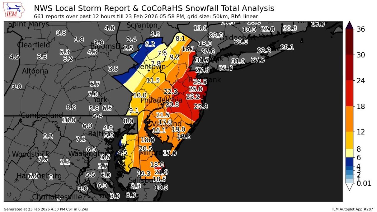
Newly released snowfall analysis from the National Weather Service Local Storm Reports and CoCoRaHS network shows a sharp gradient from western Pennsylvania into the Interstate 95 corridor, where the heaviest snow axis set up.
Philadelphia Region Sees Widespread 10 to 22 Inches
In Philadelphia, snowfall totals ranged around 20.8 inches, placing the city firmly in the higher-end band of accumulation.
Nearby communities reported:
- Allentown, PA: 7 to 11.5 inches, with higher pockets north and east
- Reading, PA: 18.1 inches
- Trenton, NJ area: 22 to 26 inches
- Wilmington, DE: Around 18 to 20.5 inches
- Vineland, NJ: Around 16 to 19 inches
The map shows a strong west-to-east increase in totals, with amounts rapidly climbing closer to the New Jersey coastline.
Coastal New Jersey Hit Hardest
The highest snowfall totals were reported along the central and northern New Jersey coast, including:
- Toms River / Monmouth County region: 25 to 27 inches
- Coastal locations: 27 to 31 inches
- Isolated reports exceeding 30 inches
This corridor was positioned beneath persistent banding that enhanced snowfall rates for several hours.
Sharp Drop-Off Into Western Pennsylvania and Maryland
While eastern sections were buried, snowfall totals dropped off dramatically farther west.
Across western and central Pennsylvania, including areas near:
- Altoona
- State College
- Clearfield
Totals were generally between 2 and 6 inches, with some isolated higher amounts.
In parts of Maryland, including areas west of Baltimore and toward Washington, D.C., totals ranged from 3 to 8 inches, significantly lower than the heavy swath just to the east.
Delaware and Southern New Jersey Also See Heavy Totals
Southern Delaware and southeastern Maryland’s Eastern Shore reported:
- 18 to 21 inches in several communities
- Salisbury, MD: Near 18 to 19 inches
- Coastal Delaware: Around 20 inches
Southern New Jersey saw widespread totals between 22 and 26 inches, particularly inland from the immediate coast.
What Made This Storm Significant?
The snowfall analysis shows a classic coastal storm setup, with:
- A tight heavy snow band aligned from southern New Jersey through eastern Pennsylvania
- Prolonged moderate to heavy snowfall rates
- Coastal enhancement boosting totals near the Atlantic shoreline
The 20+ inch totals across densely populated areas such as Philadelphia and surrounding suburbs make this one of the more impactful winter storms of the season.
Final Numbers Snapshot
Highest observed snowfall totals included:
- 30+ inches in portions of coastal New Jersey
- 25+ inches in central New Jersey
- 20+ inches across Philadelphia and much of southern New Jersey
- 18 to 21 inches across Delaware and southeastern Maryland
Meanwhile, totals fell below 10 inches just 50–100 miles west of the heaviest band.
Bottom Line
Eastern Pennsylvania, New Jersey, Delaware and Maryland were hit hardest by the Sunday–Monday winter storm, with a concentrated corridor of 20 to 30 inches stretching from Philadelphia to the New Jersey coast.
Western Pennsylvania and inland Maryland saw much lighter totals by comparison.
Stay with WaldronNews.com for continued winter storm coverage, regional breakdowns and updated snowfall analysis as reports continue to come in.