
Pennsylvania, New Jersey, Delaware and Maryland Face Sunday Severe Storm Threat as Warm 80° Air and Cold Front Trigger Isolated Strong Thunderstorms
MID-ATLANTIC — Another round of severe weather could develop Sunday across parts of Pennsylvania, New Jersey, Delaware and Maryland as a cold front pushes into an increasingly warm and unstable air mass.
While forecasters stress that this setup does not appear as intense as Monday’s recent system, the ingredients are aligning for isolated severe thunderstorms, particularly during the afternoon and evening hours.
Temperatures Climbing Toward 80 Degrees
Forecast guidance shows widespread afternoon temperatures climbing well into the 70s, with some spots nearing 80°F, especially across southern Pennsylvania, central and southern New Jersey, Delaware and eastern Maryland.
Apparent temperature maps highlight broad warm-sector conditions across:
- Philadelphia metro area
- South Jersey
- Wilmington, Delaware
- Baltimore metro region
- Southern Pennsylvania including Harrisburg and York
This early-spring warmth will help destabilize the atmosphere ahead of the approaching front.
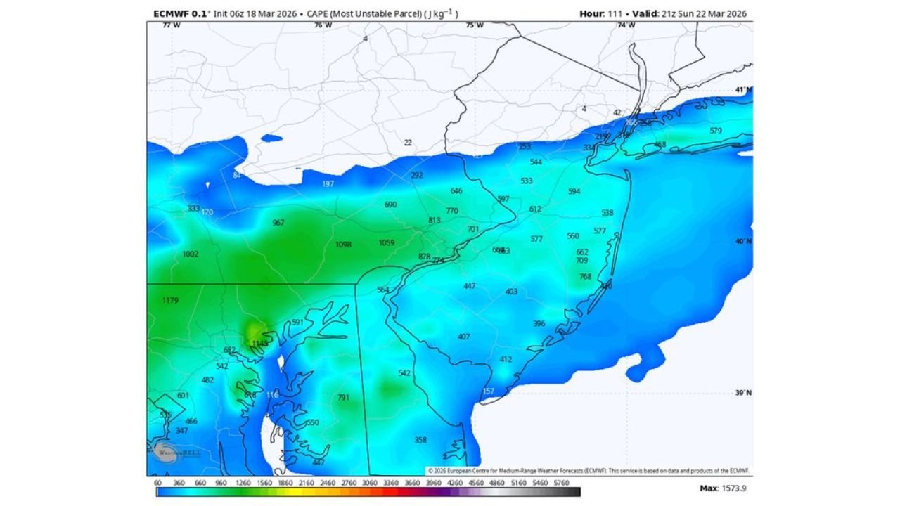
Instability Increasing Across the Region
CAPE (Convective Available Potential Energy) values are forecast to range between 800 and 1,000 J/kg, particularly across southern Pennsylvania, Delaware, Maryland and southern New Jersey.
While not extreme, this level of instability is sufficient to support strong thunderstorm development if storms can break through cloud cover.
Model guidance suggests:
- Greater instability across Maryland and southern Pennsylvania
- Moderate instability extending into central and southern New Jersey
- Lower values toward northern Pennsylvania and northern New Jersey
Cold Front Arrives Sunday
A frontal boundary moving through the Mid-Atlantic Sunday will provide the lifting mechanism needed to initiate thunderstorms.
Forecast cloud cover maps show partial clearing across portions of the region during peak heating hours. Any breaks in cloud cover would allow additional surface warming, further enhancing instability.
This combination — warm temperatures near 80°, modest instability, and frontal lift — creates the environment for:
- Isolated damaging wind gusts
- Frequent lightning
- Brief heavy downpours
- Small hail in stronger cores
Lightning Signals Indicate Scattered Storm Potential
Lightning density forecasts indicate scattered thunderstorm clusters developing across:
- Eastern Pennsylvania
- Southern and central New Jersey
- Delaware
- Northeastern Maryland
Storm coverage does not appear widespread at this time, but isolated stronger cells could pulse quickly during the late afternoon into evening.
Not as Strong as Previous System
Forecasters emphasize that this setup is not expected to rival the intensity of earlier severe events this week. Wind shear appears more limited, reducing the likelihood of widespread organized severe storms.
However, even modest setups can produce localized impacts, especially if daytime heating exceeds expectations.
Timing and What to Watch
The primary window for stronger storms appears to be:
- Sunday afternoon through early evening
Residents across Pennsylvania, New Jersey, Delaware and Maryland should monitor forecast updates, particularly if skies clear more than expected during the day.
While widespread severe weather is not anticipated at this time, isolated strong storms remain possible.
Stay with WaldronNews.com for updates as this developing Mid-Atlantic weather threat evolves heading into Sunday.