
Pennsylvania, New Jersey, Maryland, New York Face Ice, Snow, and Wintry Mix as Complex Winter System Targets Mid-Atlantic and Northeast
PENNSYLVANIA — A developing winter weather system expected late Friday into early Saturday is raising concerns across parts of the Mid-Atlantic and Northeast, with forecast data pointing toward a dangerous mix of freezing rain, sleet, and snow depending on location. Meteorologists say the setup involves cold air pressing south along the East Coast while moisture surges in from the west, creating a high-impact winter scenario for several states.
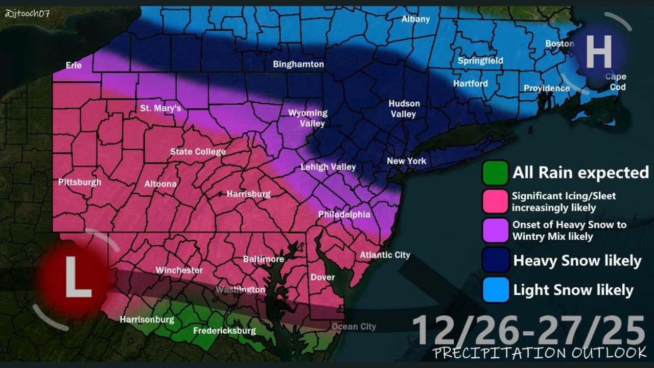
Based on current model guidance and precipitation outlooks, the most significant impacts are expected across Pennsylvania, New Jersey, Maryland, and parts of New York, with exact precipitation types varying sharply across short distances.
Ice Storm Risk Increasing Across Western and Central Pennsylvania, South Jersey, and Mountain Regions
Forecast confidence continues to grow for freezing rain and sleet across western and central Pennsylvania, southern New Jersey, and the mountainous regions of Maryland and West Virginia. Temperature profiles shown in the model data indicate surface temperatures stuck near or below freezing while warmer air moves overhead — a classic setup for ice accumulation.
Maps highlighting accumulated freezing rain suggest that significant icing is possible, especially in elevated terrain and interior valleys, which could lead to hazardous travel conditions, downed tree limbs, and power outages if ice amounts increase.
Eastern Pennsylvania and Northern New Jersey Face Uncertain Snow-to-Mix Transition
In eastern Pennsylvania, including the Lehigh Valley and Philadelphia metro, the forecast is more complex. Data suggests an initial front-end thump of heavy snow, potentially followed by a transition to sleet or freezing rain later in the event.
Forecasters note that a very cold air mass already in place may be stronger than some models currently project. Because of this, there is concern that cold air damming (CAD) could hold longer than expected, particularly across eastern Pennsylvania and northern New Jersey, increasing snowfall totals or prolonging icy conditions.
New York City Metro, Northeastern Pennsylvania, and Southern New York Favor Heavy Snow
Farther north, conditions become more favorable for all snow. The New York City metro area, northeastern Pennsylvania, and southern New York are currently positioned on the colder side of the system, where arctic air appears strong enough to block warmer air aloft.
Snowfall projections in this zone indicate a good chance of totals exceeding 4 inches, with some areas potentially seeing higher amounts if snow bands intensify. Model guidance also shows the possibility of impressive snowfall rates, which could quickly cover roads and reduce visibility during the heaviest periods.
Southern New England Snow Depends on Moisture Reach
In southern New England, including parts of Connecticut, Rhode Island, and Massachusetts, snow is possible but less certain. The key factor will be how far east the storm’s moisture shield expands and whether it can fully saturate the atmospheric column.
If moisture pushes far enough east, accumulating snow is likely. If not, impacts may remain limited compared to areas farther west and south.
Forecast Still Evolving as Friday Approaches
While confidence is growing in a wintry, high-impact setup, exact snowfall and ice totals remain uncertain at this stage. Meteorologists caution that predicting precise outcomes beyond several days is difficult, especially with competing air masses involved.
Residents across the affected states are encouraged to monitor updates closely, as small shifts in temperature or storm track could significantly change local impacts.
WaldronNews.com will continue tracking this developing winter system and provide updates as newer data becomes available. What are you seeing in your area — snow, ice, or rain? Share your local conditions and stay informed with WaldronNews.com.