
Pennsylvania, New Jersey, New York, and Maryland Braced for Significant Ice and Snow Threat as Friday Winter Storm Takes Shape
MID-ATLANTIC AND NORTHEAST — Confidence is increasing that a developing winter storm late this week could bring a dangerous mix of snow, sleet, and freezing rain across parts of the Mid-Atlantic and Northeast, with model guidance now narrowing in on where the most severe impacts are likely to occur by Friday.
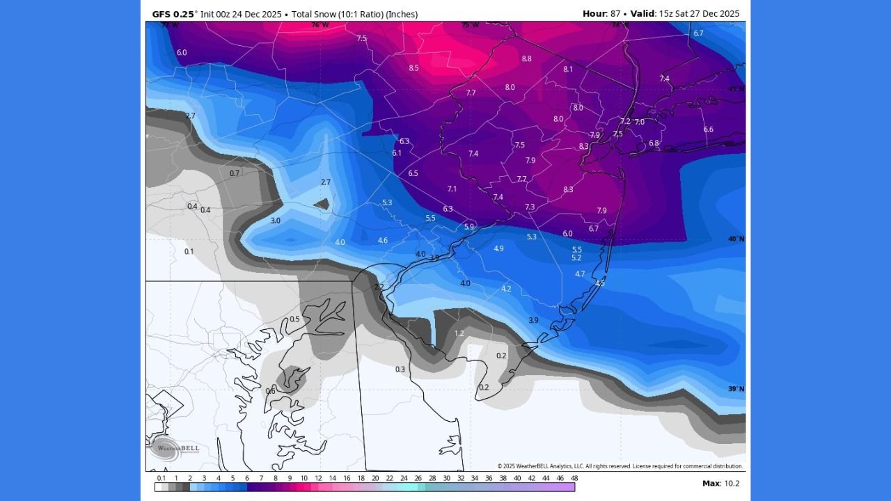
Latest GFS trends show a northward shift in the storm track, helping forecasters better identify zones where snow and ice may become heaviest. The setup involves cold air pushing south along the East Coast while a moisture-rich system advances from the west, creating a classic winter storm scenario.
Ice Storm Risk Focused Across Interior and Mountain Regions
The greatest concern for icing is centered across western and central interior zones, where freezing rain and sleet are increasingly likely. In these areas, cold air near the surface is expected to remain locked in place while warmer air moves overhead, a setup favorable for ice accumulation.
Forecast guidance suggests ice totals could become significant enough to cause hazardous travel, power disruptions, and tree damage, particularly in higher elevations and sheltered valleys where surface temperatures remain below freezing for longer periods.
Transition Zone With Heavy Snow Followed by Wintry Mix
Just east of the primary icing corridor, a transition zone is taking shape where heavy snow may develop early, followed by a gradual change to sleet or freezing rain later in the event. This zone carries the highest forecast uncertainty, as small changes in temperature profiles could dramatically alter snowfall totals.
A strong cold air mass already in place raises concerns that models may be underestimating how long snow can hold on before warmer air intrudes, especially during the first half of the storm.
Heavy Snow Potential In Northern And Northeastern Areas
Farther north, conditions appear more favorable for predominantly snow throughout the event. Arctic air in these regions is expected to be strong enough to block warm air aloft, increasing the likelihood of sustained snowfall.
Snowfall totals exceeding 4 inches are increasingly plausible here, with the potential for intense snowfall rates that could quickly reduce visibility and create dangerous road conditions during peak travel times.
Eastern Extent Of Snow Still Dependent On Storm Strength
On the eastern edge of the system, snowfall chances will depend on how aggressively moisture spreads eastward and how quickly the storm strengthens. If the system becomes more organized, snow coverage could expand; otherwise, impacts may remain lighter and more localized.
Forecast Confidence Rising, Details Still Evolving
While exact totals remain uncertain, confidence is growing that this system will bring high-impact winter weather to multiple regions, with ice and snow posing serious travel and infrastructure concerns. Additional model runs over the next 24 to 48 hours will be critical in refining impact zones and accumulation forecasts.
Stay with WaldronNews.com for continued updates, refined forecasts, and regional impact coverage as this winter storm threat continues to develop.