
Pennsylvania, Ohio, and West Virginia Face Dangerous Arctic Blast With Subzero Wind Chills Monday and Tuesday
PENNSYLVANIA — A powerful surge of Arctic air from Canada is moving into the region, setting the stage for dangerously cold conditions across western Pennsylvania, eastern Ohio, and northern West Virginia early this week. According to National Weather Service guidance, wind chills are expected to drop near or below zero, with the most severe conditions likely Monday and Tuesday.
Forecasters warn this will be one of the coldest stretches of the winter so far, driven not just by low temperatures but by persistent, gusty winds that will significantly increase the risk of frostbite and hypothermia.
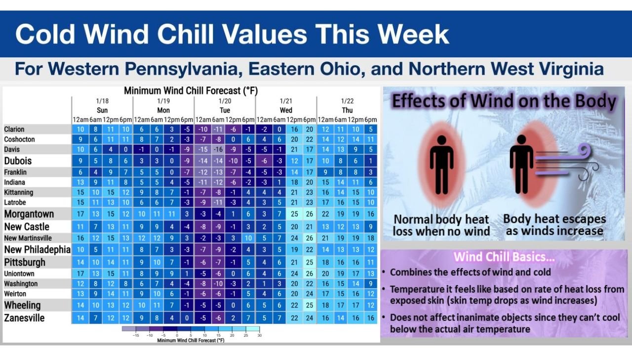
What the Wind Chill Forecast Shows
Updated wind chill tables released by the National Weather Service in Pittsburgh highlight widespread subzero or near-zero values, especially during overnight and early morning hours.
Key takeaways from the data:
- Monday morning: Many locations fall into the -5°F to -15°F wind chill range
- Tuesday morning: Coldest period, with similar or slightly colder values in some areas
- Daytime hours: Temperatures recover modestly, but wind chills remain bitter due to steady winds
Cities and towns across western Pennsylvania, eastern Ohio, and northern West Virginia are all expected to experience hazardous cold, with little relief until midweek.
Why This Cold Is Especially Dangerous
Wind chill measures how quickly heat is lost from exposed skin. Even when air temperatures are above zero, strong winds dramatically accelerate heat loss.
According to meteorologists:
- Exposed skin can begin to experience frostbite in as little as 30 minutes
- Children, seniors, outdoor workers, and unhoused individuals are at highest risk
- Pets and livestock are also vulnerable to prolonged exposure
This is not just uncomfortable cold—it is potentially life-threatening if proper precautions are not taken.
Timeline: Cold Through Tuesday Morning
The Arctic air mass settles in late Sunday and intensifies overnight.
- Sunday night: Rapid temperature drop as winds increase
- Monday: Coldest daytime conditions with brisk winds
- Tuesday morning: Peak wind chill threat, especially before sunrise
- Wednesday: Gradual moderation begins, but cold lingers
While this event may not reach the historic extremes seen in some past winters, it remains serious and impactful for the region.
Safety Reminders for Residents
Officials urge residents to take this cold outbreak seriously:
- Limit time outdoors, especially during early morning hours
- Dress in layers, covering hands, face, and ears
- Check on neighbors, particularly the elderly or those without reliable heat
- Bring pets indoors and protect exposed pipes from freezing
Local emergency managers may also open warming centers if conditions warrant.
Bottom Line
This Arctic blast will bring some of the harshest wind chills of the season to Pennsylvania, Ohio, and West Virginia, with dangerous cold peaking Monday and Tuesday. While temperatures will eventually rebound, the next 48 hours require heightened awareness and caution.
Stay with Waldron for continued updates on this Arctic outbreak, including any wind chill advisories or warnings issued for your area. Share how cold it gets where you are and check back as conditions evolve.