
Pennsylvania Weather Alert Pittsburgh State College Harrisburg Philadelphia Face Afternoon Storm Risk Before Sudden Evening Temperature Drop
PENNSYLVANIA — A pleasant and warm Saturday is unfolding across much of the state, but residents in cities including Pittsburgh, State College, Harrisburg, Philadelphia, and Scranton are being urged to stay alert as storm chances increase later this afternoon into the evening.
While much of the daytime will remain dry and comfortable, changing conditions later today could bring scattered storms and a sharp temperature shift.
Warm and Quiet Start Before Storm Chances Increase
Across Pennsylvania, temperatures are climbing into the:
- Upper 70s to low 80s in western and central areas including Pittsburgh and Altoona
- Low to mid 70s across eastern cities like Philadelphia and Allentown
This warm setup will make for a pleasant start to the day, with plenty of dry hours expected statewide.
However, this calm pattern will not last through the evening.
Storms Likely to Develop After 3 PM
Weather signals indicate that storm development will begin after mid-afternoon, especially:
- Western Pennsylvania near Pittsburgh toward sunset
- Central Pennsylvania including State College, Altoona, and Williamsport
- Isolated activity spreading east toward Harrisburg and surrounding areas
These storms are expected to be scattered rather than widespread, but a few could bring:
- Gusty winds
- Brief downpours
- Isolated thunderstorm activity
Overall, the risk appears low-end but worth monitoring, particularly for late-day outdoor plans.
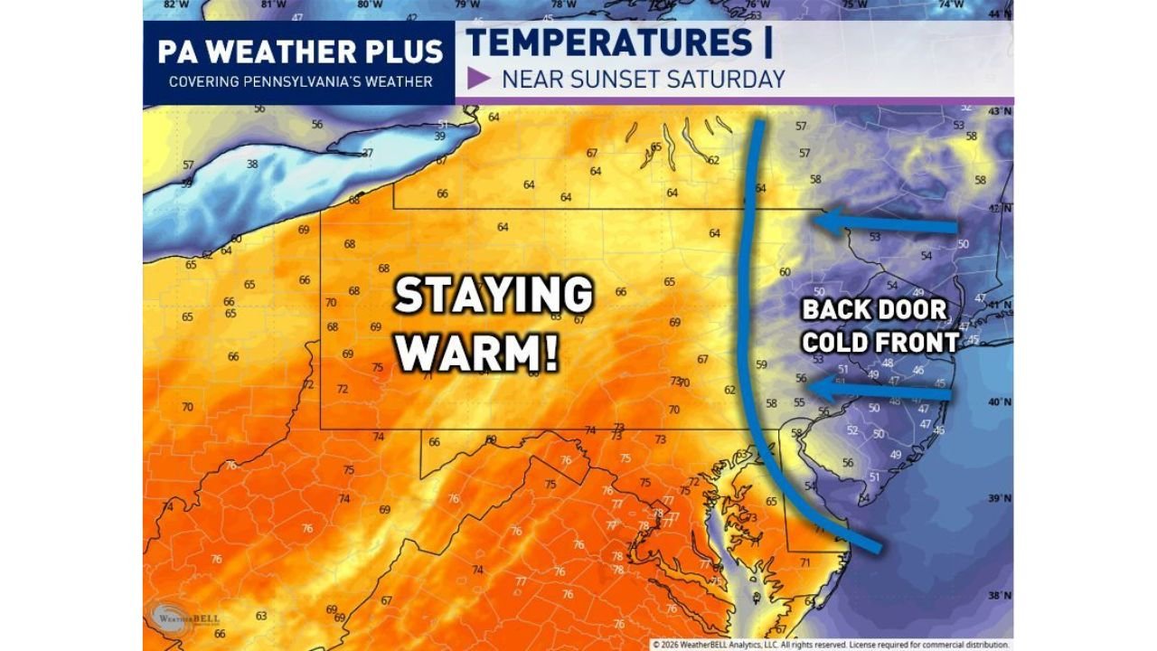
“Backdoor Cold Front” Brings Sudden Evening Temperature Drop
One of the most important features in today’s setup is a backdoor cold front moving into eastern Pennsylvania later in the evening.
This will lead to:
- A rapid drop in temperatures after sunset
- Areas that reach the 70s during the day falling into the 40s and 50s by evening
- Noticeably cooler air pushing in from the east off the Atlantic
Cities most impacted by this sharp change include:
- Philadelphia
- Allentown
- Reading
- Scranton
This type of front can create a dramatic and quick shift, catching many off guard.
Eastern Pennsylvania Sees the Biggest Temperature Swing
While western areas may cool gradually, eastern Pennsylvania will experience the most abrupt change, with:
- Warm afternoon conditions quickly turning chilly by evening
- Increasing cloud cover and possible lingering showers
Residents should be prepared for a completely different feel to the weather within just a few hours.
What to Expect Through Tonight
- Afternoon: Warm, mostly dry with increasing clouds
- Late Afternoon to Evening: Scattered storms develop, especially west and central
- Evening: Cold front pushes in from the east with rapidly falling temperatures
- Night: Cooler, calmer conditions take over statewide
Final Outlook
Pennsylvania is looking at a two-part weather day, featuring a warm and pleasant start followed by scattered afternoon storms and a sharp evening cooldown, especially across Philadelphia, Harrisburg, State College, and Pittsburgh.
Residents should enjoy the early-day warmth but stay weather-aware later today, as storms and a fast-moving cold front could quickly change conditions.
Stay with WaldronNews.com for continued updates on today’s evolving weather across Pennsylvania.