
Pennsylvania Winter Storm Forecast Shows Widespread Snow, Ice, and Dangerous Travel From Friday Afternoon Into Saturday
PENNSYLVANIA — A significant post-Christmas winter storm is forecast to impact much of Pennsylvania from Friday afternoon through early Saturday, bringing a dangerous mix of snow, sleet, and ice that could make travel hazardous to nearly impossible across large portions of the state.
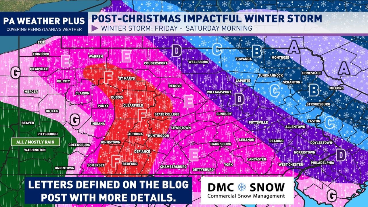
Forecast data shows a strong low-pressure system moving southeast from Canada and Minnesota, interacting with entrenched Arctic air supplied by high pressure over Quebec. This setup will create widespread precipitation across Pennsylvania, with sharp temperature contrasts leading to major differences in impacts from west to east.
Storm Timing and Overall Setup
The storm is expected to begin spreading into western and central Pennsylvania Friday morning, intensify through the afternoon and evening, and continue overnight before tapering off from west to east Saturday morning.
Warm air aloft associated with a warm front will override colder surface air, creating conditions favorable for heavy precipitation, frontogenesis, and strong lift. This dynamic setup raises the risk of both heavy snowfall and significant icing, depending on location.
Central Pennsylvania Faces Ice and Sleet Threat
Central Pennsylvania, including the central Appalachians and Laurel Highlands, is expected to see the most dangerous icing conditions.
Forecast guidance indicates surface temperatures remaining below freezing while a warm nose aloft near 750 mb prevents snow from forming. As a result, freezing rain and sleet are likely to dominate in these areas.
Significant ice accretion could lead to:
- Extremely slick roadways
- Downed trees and power lines
- Prolonged power outages
- Travel conditions becoming unsafe or impossible Friday evening into overnight
Eastern Pennsylvania Snowfall Gradient Creates Sharp Cutoff
Eastern Pennsylvania is forecast to sit along a tight transition zone where snowfall totals may vary dramatically over short distances.
The Lehigh Valley and parts of northeastern Pennsylvania could see heavy snowfall, with some locations potentially exceeding 6 inches, while areas just 10–15 miles west may see lower totals due to sleet mixing in.
This sharp gradient means snowfall totals will be highly location-dependent, and small shifts in storm track could significantly alter outcomes.
Philadelphia Metro and Surrounding Areas See Mixed Impacts
The northern portions of the Philadelphia metro area are expected to see a mix of snow and sleet, while areas farther south may experience more sleet or freezing rain at times.
Snowfall rates in heavier bands could exceed 1 to 2 inches per hour, especially if thundersnow develops in localized areas where lift is strongest.
Travel during Friday evening and overnight hours is strongly discouraged as conditions may deteriorate rapidly.
Western Pennsylvania Sees Lower Snow, Mainly Rain South
Western Pennsylvania will generally see lighter winter impacts compared to central and eastern regions.
Far southwestern areas closer to the Ohio and West Virginia borders may see periods of rain or a rain-snow mix, while higher elevations farther north could still experience accumulating snow.
Travel and Safety Concerns
This storm is expected to coincide with heavy post-Christmas travel, significantly increasing risk on highways and secondary roads.
Residents are urged to:
- Avoid unnecessary travel Friday afternoon through early Saturday
- Prepare for possible power outages in ice-prone areas
- Monitor local forecasts closely as small changes could lead to major impact shifts
What Happens Next
Additional updates and refined snowfall and ice maps are expected as the storm approaches. Forecast confidence is high regarding significant impacts, but exact totals will depend on the precise placement of the rain-snow-ice boundary.
WaldronNews.com will continue to monitor the situation and provide updates as new information becomes available.