
Persistent Bermuda High to Bring 70s and 80s to the Carolinas and Mid-Atlantic March 5–11 Before Possible Cold Flip Returns
UNITED STATES — Forecast guidance continues to signal a strong and persistent Bermuda high setting up along the East Coast next weekend into the following week, potentially delivering widespread 70s and even 80-degree temperatures from the Carolinas north through Virginia and Maryland before colder air may return later in the month.
The pattern, projected for roughly March 5–11, shows a pronounced ridge of high pressure anchored off the Southeast coast — a classic warm-season configuration more typical of April than early March.
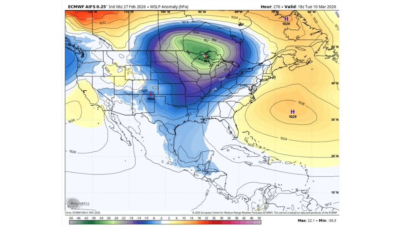
What the Pressure Maps Show
The ECMWF mean sea level pressure anomaly forecast highlights:
- A strong high pressure center (around 1028–1029 mb) positioned over the western Atlantic.
- A deep trough centered over the Upper Midwest and Great Lakes.
- Below-normal pressure extending into the central U.S.
- Strong southerly flow pumping warm air up the Eastern Seaboard.
This setup promotes sustained southwest winds across North Carolina, South Carolina, Virginia, Maryland, Delaware, and southern Pennsylvania, allowing temperatures to surge well above seasonal averages.
How Warm Could It Get?
The 2-meter temperature forecast map valid around March 10 shows:
- Upper 70s to near 80°F across eastern North Carolina.
- Mid to upper 70s across central North Carolina and South Carolina.
- Low to mid 70s into Virginia and Maryland.
- Upper 60s to low 70s pushing into parts of New Jersey.
- Cooler 50s lingering across coastal New England due to marine influence.
Cities that could see springlike warmth include:
- Raleigh, NC: Upper 70s
- Charlotte, NC: Mid to upper 70s
- Columbia, SC: Near 80°F
- Richmond, VA: Low to mid 70s
- Washington, D.C.: Low to mid 70s
- Baltimore, MD: Around 70°F
Such warmth would likely jumpstart early grass growth and budding vegetation across much of the Southeast and Mid-Atlantic.
Why This Pattern Develops
A Bermuda high strengthens when ridging expands over the western Atlantic, often supported by:
- Subtropical high pressure expansion.
- Jet stream displacement northward.
- Reduced blocking in the North Atlantic.
At the same time, a trough digging into the Midwest reinforces warm southerly flow east of the Mississippi River.
But a Cold Flip May Follow
While the warmth looks persistent through the March 5–11 window, longer-range signals suggest this may not last.
The Madden-Julian Oscillation (MJO) phase forecast indicates movement into phases that historically favor:
- Increased eastern U.S. troughing.
- Colder air intrusions later in March.
- A return to more seasonable or even below-average temperatures.
The ensemble spaghetti plots show growing variability beyond mid-month, suggesting the pattern could break down and allow cooler Canadian air to spill back south.
What This Means Going Forward
If this Bermuda high locks in as projected:
- Expect multiple days in the 70s for the Carolinas and Virginia.
- Outdoor activity conditions will feel more like mid-spring.
- Early pollen season may accelerate.
However, residents should not assume winter is finished. Large-scale climate signals point toward a possible reversal later in the month.
For now, the East Coast appears set for an extended early taste of spring before atmospheric signals hint at another potential cool-down.
Stay with WaldronNews.com as we continue tracking how long this warm stretch lasts — and whether March delivers another late-season chill.