
Philadelphia Snow Forecast Swings From 24 Inches to a Coating as Models Clash on Sunday Storm Track Across Pennsylvania, New Jersey and New York
PENNSYLVANIA — Forecast confidence remains exceptionally low ahead of the approaching Sunday snowstorm, as major global models continue to produce dramatically different snowfall outcomes — especially for Philadelphia and surrounding parts of the Mid-Atlantic and Northeast.
Morning model updates show projected totals for Philadelphia ranging from as much as 24 inches… to 6 inches… to 2 inches… to barely a coating, underscoring just how uncertain the setup remains.
Models in Complete Disagreement
The latest snowfall guidance highlights extreme variability across the region:
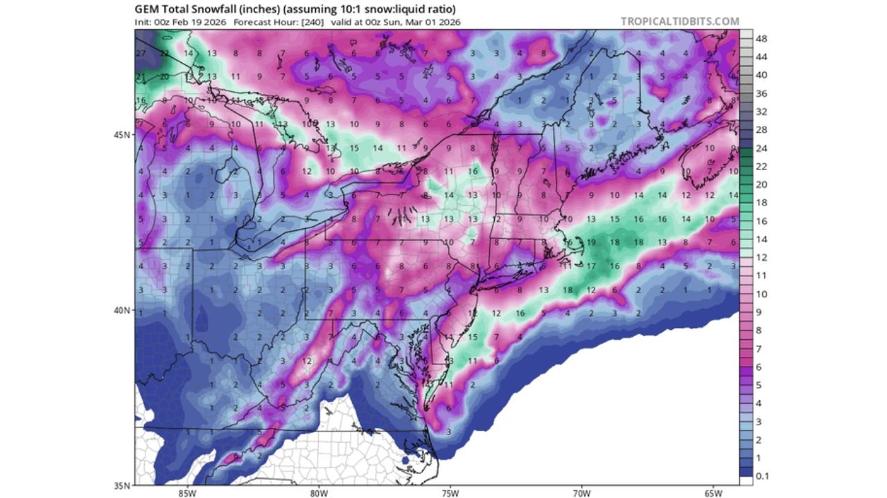
- One high-end solution shows widespread double-digit snowfall from eastern Pennsylvania into northern New Jersey and upstate New York.
- Another model trims totals significantly, keeping most locations in the 2–6 inch range.
- A lower-end solution limits accumulations to light snow or minor impacts.
- Yet another scenario produces only scattered light totals across much of the Mid-Atlantic.
This wide spread reflects fundamental disagreement on storm structure, timing, and track — particularly whether the system phases strongly and intensifies near the coast.
Philadelphia at the Center of the Forecast Spread
Few cities illustrate the uncertainty more clearly than Philadelphia.
Across current guidance:
- One projection paints two feet or more in parts of eastern Pennsylvania.
- Another holds totals near 6 inches.
- Others drop accumulations to 2 inches or less.
- Some solutions barely show measurable snow at all.
Such divergence signals that the storm’s track and upper-level alignment remain unresolved.
Broader Impacts From D.C. to Boston
Beyond Philadelphia, snowfall forecasts vary widely across:
- Washington, D.C.
- Baltimore
- New York City
- Boston
- Interior Pennsylvania
- Upstate New York
Some guidance clusters heavier snowfall across interior sections, while others shift the axis offshore or suppress intensification entirely.
The difference appears tied to whether the system strengthens aggressively once it reaches the East Coast — or remains weaker and more progressive.
Why Friday’s Update May Be More Reliable
Forecasters note that later model runs — particularly by Friday afternoon — should carry more weight because the storm will be fully onshore and better sampled by weather observation networks.
Until then:
- Small shifts in upper-level energy could dramatically alter totals.
- Coastal development strength remains uncertain.
- Snow-to-liquid ratios may vary significantly.
When models disagree this sharply, historical trends often favor lower-end outcomes — but it remains too early to rule out a higher-impact event.
Timing Remains Sunday Into Monday
Regardless of final totals, the storm is expected to affect the region Sunday into Monday.
Travel impacts are possible if higher-end scenarios materialize, especially across eastern Pennsylvania, northern New Jersey, and southern New York.
However, a suppressed or weaker solution could result in minimal disruption.
Bottom Line
The Sunday snowstorm forecast across Pennsylvania, New Jersey, and New York remains highly volatile, with projected snowfall totals swinging from extreme to negligible depending on the model.
Philadelphia currently sits at the epicenter of the uncertainty, with totals ranging from blockbuster levels to little more than flurries.
Confidence should improve once the system comes ashore and additional data feeds into model guidance.
WaldronNews.com will continue tracking updates as this evolving forecast becomes clearer heading into the weekend.