
Plains and Southern States See 40–55 Degree Temperature Plunge Across Texas, Oklahoma, Arkansas, Mississippi, and Tennessee
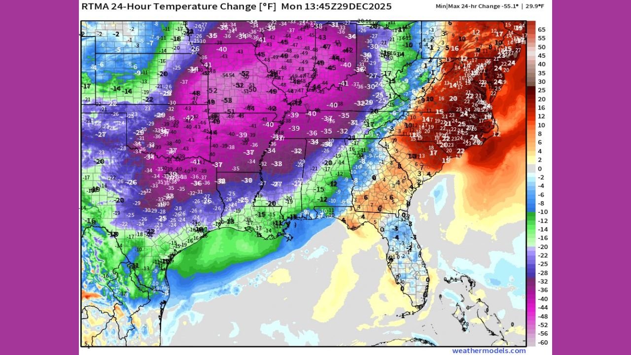
UNITED STATES — A powerful Arctic front sweeping across the central and southern United States has triggered an extraordinary 24-hour temperature collapse, with parts of the Plains and Deep South recording drops of 40 to more than 55 degrees Fahrenheit, according to high-resolution RTMA temperature change data.
The most dramatic impacts were concentrated across Texas, Oklahoma, Arkansas, Missouri, Mississippi, Tennessee, and parts of the Lower Mississippi Valley, where communities went from spring-like warmth to winter conditions in less than a day.
Central Plains and Lower Mississippi Valley Hit Hardest
The most severe temperature drops were observed across Oklahoma, Arkansas, northern Texas, Missouri, and western Tennessee, where temperature changes on the map show widespread 40–55°F declines in just 24 hours.
Large portions of:
- Oklahoma
- Arkansas
- Northern and Central Texas
- Missouri
- Western Tennessee
- Northern Mississippi
experienced the sharpest cooling, with deep purple and pink shading indicating the core of the Arctic air mass settling southward.
Texas and Oklahoma Experience Sudden Winter Shift
In Texas, temperatures plunged sharply behind the cold front, especially across northern and central parts of the state. Areas that were mild and humid one day dropped into much colder conditions overnight, accompanied by strong winds that intensified the chill.
Oklahoma saw similar conditions, with widespread temperature drops exceeding 45 degrees in many locations, marking one of the most abrupt temperature transitions of the season.
Mississippi, Tennessee, and Arkansas Follow Close Behind
Across Arkansas, Mississippi, and Tennessee, the temperature collapse was nearly as intense. Many communities experienced a rapid shift from mild weather to near-freezing conditions within hours, stressing infrastructure and catching residents off guard.
Meteorologists note that such sharp gradients increase the risk of freeze impacts, including damage to pipes, sensitive vegetation, and increased heating demand.
Southeastern States See Sharp but Lesser Declines
While not as extreme, parts of the Southeast — including Alabama, Georgia, and northern Florida — also recorded notable temperature drops ranging from 15 to 30 degrees, with the strongest cooling focused inland.
Coastal and southern Florida remained comparatively warmer, though still cooler than seasonal averages.
Why the Temperature Drop Was So Extreme
The data shows a classic strong Arctic air intrusion, with cold air rapidly surging southward behind a powerful frontal boundary. The steep temperature gradient from the Plains into the Southeast explains the dramatic color contrast seen on the map, from deep purples in the central U.S. to oranges along the East Coast.
Meteorologists say this setup allows cold air to advance rapidly, leaving little time for gradual adjustment.
What Comes Next
Behind the front, cold and windy conditions will persist across much of the affected region, increasing the risk of dangerous wind chills, especially overnight. Additional disturbances could reinforce the cold air, keeping temperatures below normal for several days.
Residents across the Plains and South are urged to:
- Protect exposed pipes
- Check heating systems
- Monitor updated forecasts as conditions evolve
This story will be updated as new temperature data and advisories are issued.
For continued regional weather coverage and real-time updates, follow WaldronNews.com.