
Plains to Midwest Put on Alert as Multi Day Severe Weather Threat Builds April 12 to April 18 Across Texas Oklahoma Kansas Missouri Illinois and Iowa
UNITED STATES — A significant shift in the weather pattern is now setting up across the central United States, with multiple days of severe weather expected between April 12 and April 18, stretching from Texas through Oklahoma, Kansas, Missouri, Illinois, and into Iowa.
This is not a one-day event. Instead, the setup points toward a prolonged and potentially dangerous stretch of storm activity, with several rounds of thunderstorms possible across the Plains and extending into parts of the Midwest.
Multi Day Severe Risk Zone Expands Across Central U.S.
Forecast signals show a large corridor of concern developing:
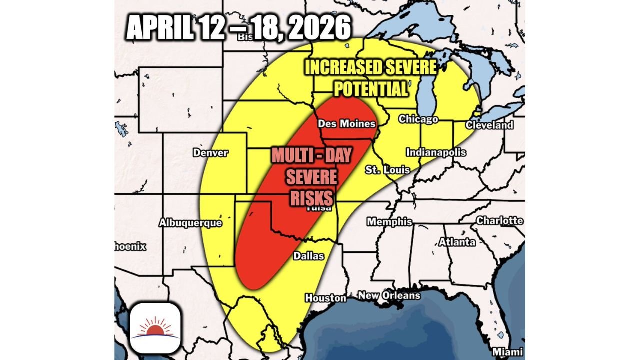
- Core high-risk zone: North Texas, Oklahoma, Kansas into Iowa
- Expanded risk zone: Extending east into Missouri, Illinois, Indiana, and toward the Great Lakes
Cities like Dallas, Tulsa, Des Moines, Kansas City, Chicago, and St. Louis sit either directly in or very close to this evolving risk zone.
This means millions of people across these regions could face repeated storm chances over multiple days, rather than a single isolated outbreak.
Why This Pattern Is Concerning
The setup is being driven by a classic spring configuration:
- A persistent trough over the western U.S.
- Warm, moisture-rich air surging north from the Gulf
- Increasing wind energy aloft across the Plains and Midwest
This combination creates the perfect environment for organized severe thunderstorms, including:
- Large hail
- Damaging wind gusts
- Tornado potential
As this pattern locks in, storms may develop daily along boundaries and shift eastward over time.
Timing Window to Watch Closely
The most active window currently highlighted runs from:
- Sunday, April 12 through Saturday, April 18
Within this period:
- Early activity may begin across Texas and Oklahoma
- The threat is expected to expand north into Kansas and Iowa
- Later in the stretch, storms could push east into Missouri, Illinois, and surrounding states
Because this is a multi-day setup, each day may bring a different target area, increasing the overall risk footprint.
Midwest Could See Increasing Threat Later in the Period
While the Plains will likely be the starting point, attention will shift farther north and east as the week progresses.
Areas including:
- Iowa
- Illinois
- Indiana
- Great Lakes region
could see elevated severe weather potential, especially as storm systems track out of the Plains.
Residents Should Begin Preparing Now
With a prolonged severe weather pattern developing, this is the time to prepare:
- Review your severe weather safety plan
- Ensure you have multiple ways to receive warnings
- Identify a safe shelter location in your home
- Stay updated daily as forecast details become more refined
Even though exact day-to-day storm details are still evolving, confidence is increasing that this will be an active and potentially impactful stretch of weather across a large part of the country.
What Happens Next
Forecast clarity will improve as the event gets closer, but one thing is already clear:
This is not a typical short-lived system — it is a sustained severe weather pattern that could bring repeated risks across the Plains and Midwest.
Stay alert, monitor updates closely, and be ready to act as conditions develop through the week.