
Potential Early Severe Weather Window Emerges for Texas, Louisiana, Mississippi, Alabama and Tennessee Around February 12–14
UNITED STATES — Long-range forecast signals are beginning to hint at a possible early-season severe weather setup across parts of the central and southern United States during the February 12–14 timeframe, according to ensemble guidance and atmospheric pattern analysis. While the event remains more than a week away, multiple indicators suggest the atmosphere could briefly turn more favorable for organized storms across the Deep South and Lower Mississippi Valley.
Meteorologists stress that this is not a forecast yet, but rather an early heads-up based on pattern recognition as the country moves closer to the traditional start of severe weather season.
Why Forecasters Are Watching the February 12–14 Window
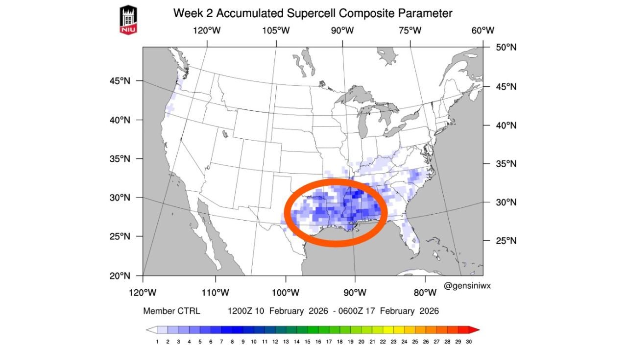
Ensemble model guidance shows a noticeable uptick in the Supercell Composite Parameter (SCP) during the middle of February, particularly between February 12 and February 14. This coincides with signals of increasing atmospheric instability and stronger wind fields aloft—both key ingredients for severe thunderstorms.
The data suggests this period could represent an early transition from winter-dominated weather patterns into a more spring-like storm setup across the southern tier of the U.S., which is not uncommon during strong pattern shifts.
Regions Showing the Strongest Signal So Far
Based on current ensemble clustering and highlighted areas on the model guidance, the most consistent signals are centered over:
- Eastern Texas
- Louisiana
- Southern and central Mississippi
- Western and central Alabama
- Parts of Tennessee
These regions fall within a corridor where increasing moisture, strengthening jet stream winds, and rising instability may overlap if the pattern evolves as currently suggested.
At this range, it is impossible to pinpoint exact cities or storm modes, but the broader regional signal is strong enough to warrant early attention.
Upper-Level Pattern Supports Storm Organization
Mid-level (500mb) pattern projections show a broad trough approaching from the west, accompanied by stronger southwesterly flow aloft. This type of setup is often associated with enhanced wind shear—an important ingredient for rotating storms.
At the same time, lower-level wind vectors suggest the potential for moisture transport northward from the Gulf of Mexico, a key factor in fueling stronger convection across the southern states.
What the Supercell Composite Parameter Is Indicating
The Supercell Composite Parameter is a diagnostic tool that combines multiple atmospheric ingredients—instability, wind shear, and storm-relative helicity—into a single value that highlights environments supportive of supercells.
While SCP values alone do not guarantee severe weather, a rising trend across ensemble members during this window suggests the atmosphere could briefly become more supportive of organized severe storms compared to earlier February periods.
Still Too Early for Specific Impacts
It’s important to emphasize that this signal remains far out in time, and details will almost certainly change. Storm coverage, intensity, and exact locations cannot be determined yet, and in some cases these early signals weaken or shift entirely.
However, the presence of a consistent pattern signal serves as a reminder that severe weather season is approaching quickly, with climatology showing we are less than a month away from the typical ramp-up across the South.
What to Watch Going Forward
Over the next several days, forecasters will be watching for:
- Persistence of the SCP signal in future model runs
- Better agreement among ensemble members
- Improved clarity on moisture return from the Gulf
- Refinement of upper-level trough timing and placement
If these elements remain aligned, confidence in a meaningful severe weather window could increase.
Bottom Line
An early-season severe weather pattern may begin to take shape across parts of Texas, Louisiana, Mississippi, Alabama, and Tennessee around February 12–14. While this is not a forecast, it is an early indicator that winter may briefly loosen its grip as the atmosphere transitions toward spring.
Residents across the southern U.S. should stay weather-aware as the pattern becomes clearer in the days ahead.
Stay with WaldronNews.com for continued updates as this potential early severe weather setup evolves. We’ll break down the latest data, timing changes, and risk areas as confidence increases.