
Potential Late-December Winter Storm Threatens Arkansas, Tennessee, and Kentucky With Snow and Ice as Cold High Pressure Spreads Across the Region
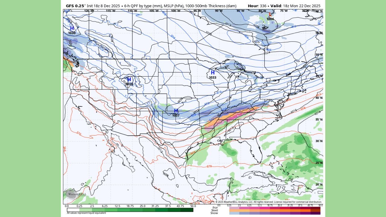
UNITED STATES — A strengthening area of cold high pressure across the central part of the country is setting the stage for a potential winter storm that may bring snow, ice, and hazardous travel conditions to portions of Arkansas, Tennessee, and Kentucky in the days leading up to Christmas. The developing pattern shows cold air pressing southward while moisture gathers to the east and southeast, creating an environment that often produces wintry precipitation during late December.
Cold Air Pushing Deep Into the Central U.S.
A large dome of Arctic-origin high pressure, centered near the Southern Plains, is expected to push cold air into the Mid-South. This surge of cold air could extend far enough south to overlap with incoming moisture, raising the likelihood of freezing rain, sleet, or snow along a broad west-to-east corridor.
The leading edge of this cold air mass may settle across:
- Northern Arkansas
- Middle and Western Tennessee
- Central and Eastern Kentucky
Such a setup often creates sharp temperature contrasts that influence which areas see snow, which see ice, and which remain just above freezing.
A Narrow but Potentially Impactful Wintry Band
Moisture moving across the South may interact with the shallow layer of cold air, forming a narrow strip of wintry precipitation stretching from Oklahoma into the Appalachian region. Depending on how the cold air positions itself, affected locations could experience:
- Accumulating snow
- Sleet mixing with snow
- Freezing rain in pockets where warm air overrides surface cold
Even light ice accumulation can lead to dangerous travel, tree damage, and scattered power disruptions.
Travel Concerns Ahead of the Holiday Week
With the potential timeline falling near December 22, the days before Christmas bring heavy travel across the region. Residents and travelers should be alert to changing weather conditions, especially those driving long distances through the Mid-South or Ohio Valley.
Areas at higher elevation in eastern Kentucky and the southern Appalachians may be more prone to heavier snow, while lower elevations could experience messy wintry mixes that make roadways slick and unpredictable.
Cold High Pressure Continues to Expand Eastward
The expanding high-pressure system may continue to influence weather patterns across the eastern United States, reinforcing cold temperatures and increasing the chance that any passing moisture results in wintry weather rather than rain. This setup is characteristic of late-December events that bring impactful storms to the central and eastern states.
While the exact timing and track remain subject to natural atmospheric variation, the combination of cold air, moisture, and regional pressure changes supports the potential for hazardous winter weather in several states.
For continuing coverage of winter weather developments, safety updates, and holiday travel guidance, follow WaldronNews.com. Stay informed, stay prepared, and stay safe as the holiday season approaches.