
Powerful March Storm Engine Ignites From Texas to Missouri, Aiming Strong Winds and Severe Weather Toward Arkansas and the Midwest
UNITED STATES — A powerful upper-level storm system is revving up across the central United States, with forecast data showing a tightly wound low-pressure center near eastern Colorado and western Kansas that will send strong winds and potentially dangerous weather from Texas to Missouri — including impacts for Arkansas.
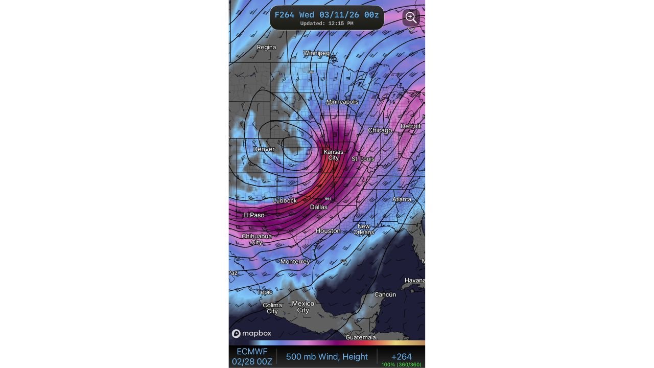
The latest European model (ECMWF) projection valid for Wednesday, March 11, 2026 (00z) highlights a classic spring storm setup intensifying across the Plains.
Deepening Low Spins Near Colorado and Kansas
The map shows a well-defined mid-level low centered near the Colorado–Kansas border, just east of Denver. Tightly packed height contours wrap around the system — a clear signal of strengthening energy in the atmosphere.
Cities positioned near the core circulation include:
- Denver
- Kansas City
- Lubbock
- Dallas
- El Paso
The strongest upper-level winds are shown streaking from northern Mexico through West Texas and into Missouri and the Midwest. The intense jet stream energy is aimed directly from El Paso and Lubbock through Dallas, Kansas City, and toward St. Louis and Chicago.
This configuration typically signals a rapidly strengthening storm system.
Powerful Jet Stream Targets the Central U.S.
At the 500mb level (roughly 18,000 feet above ground), winds are projected to be exceptionally strong. The deep magenta and red shading stretching from Chihuahua City and El Paso through Dallas and Kansas City indicates a powerful jet streak lifting northeast.
Downstream impacts extend toward:
- St. Louis
- Chicago
- Detroit
- Minneapolis
- Winnipeg
The tight gradient and strong southwest-to-northeast wind flow suggest a dynamic, fast-moving storm capable of producing:
- Widespread strong surface winds
- Rapid temperature changes
- Thunderstorm development along frontal boundaries
- Heavy precipitation bands
What This Means for Arkansas
While the low is centered west of Arkansas, the state sits directly in the corridor of strengthening southwesterly flow aloft.
For Waldron and surrounding areas, this setup typically supports:
- Increasing gusty winds
- Strong warm air advection ahead of the system
- Elevated severe weather potential if surface instability develops
- Rapid changes in conditions within a short window
Storm systems positioned this way often intensify as they track northeast, with the warm sector expanding eastward into Arkansas before the cold front sweeps through.
Midwest and Great Lakes in the Storm’s Path
As the system lifts northeast, major metro areas including Kansas City, St. Louis, Chicago, and Detroit appear positioned within the strongest wind corridor.
Minneapolis and parts of southern Canada near Winnipeg remain on the colder side of the system, where precipitation type could vary depending on thermal profiles.
The sharp contrast between warm air streaming north from Texas and cooler air over the Upper Midwest adds further energy to the storm structure.
A Classic Early-Spring Powerhouse
March is notorious for producing powerful, dynamic storm systems across the Plains and Midwest. This setup features:
- A deepening mid-level low
- Strong jet stream coupling
- Expansive southwest wind flow
- Significant atmospheric energy transfer
When systems align this way, impacts can stretch across multiple states within 24–48 hours.
Arkansas residents should monitor updates closely as this storm engine develops and lifts northeast midweek.
For continued coverage of this evolving system and how it may impact Waldron and Scott County, stay with WaldronNews.com for the latest weather analysis and forecast updates.