
Powerful Nor’easter Could Dump 20–30+ Inches of Snow Across Pennsylvania, New York, and New England as 983mb Low Targets New Jersey Coast
UNITED STATES — A strengthening coastal storm is showing signs of becoming a significant late-February Nor’easter, with the 6z GFS model run indicating a deepening 983mb low pressure system near the New Jersey coast early Monday, February 23. The setup supports widespread snow from eastern Pennsylvania through New York and into much of New England.
Forecast data suggests this could be one of the more impactful snow events of the month if current projections hold.
Deepening Low Near New Jersey Sets Up Classic Nor’easter Pattern
The latest GFS 0.25° run (initialized 06z February 16) shows a coastal low forming just offshore of the Mid-Atlantic and strengthening near southern New Jersey and Long Island by early Monday.
Cold air remains firmly in place across the interior Northeast, allowing precipitation to fall primarily as snow from:
- Eastern and central Pennsylvania
- Interior and eastern New York
- Northern New Jersey
- Connecticut
- Rhode Island
- Massachusetts
- Vermont
- New Hampshire
- Maine
Heavier precipitation is shown offshore, but a broad snow shield wraps back into the I-95 corridor and interior New England.
Coastal mixing remains possible along parts of southern New Jersey and immediate shoreline areas, depending on the final storm track.
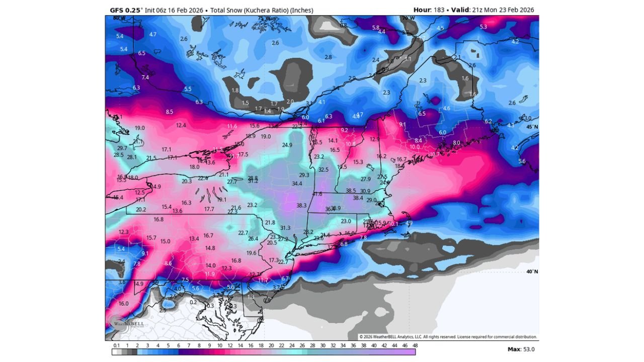
Snowfall Totals Could Exceed 20–30 Inches in Parts of New England
The total snowfall projection (Kuchera ratio) valid 21z Monday, February 23, highlights a large swath of significant accumulations across the Northeast.
Current model guidance suggests:
- 10 to 20 inches across eastern Pennsylvania and interior northern New Jersey
- 15 to 25 inches through central and eastern New York
- 20 to 30+ inches across portions of Connecticut, Massachusetts, Vermont, New Hampshire, and Maine
Localized heavier banding could push totals above 30 inches where mesoscale snow bands develop.
Western Pennsylvania and far western New York see lower totals compared to the heavier axis closer to the coastal front.
Timing: Late Sunday Night Through Monday
Based on current projections:
- Snow begins late Sunday night
- Heaviest snowfall likely Monday
- Gradual tapering into late Monday night or early Tuesday
Strong pressure gradients around the deepening 983mb low could also bring gusty northeast winds, leading to blowing and drifting snow — especially across open areas of New England.
Track Will Determine Final Impacts
As with any coastal storm, small shifts in the track will dramatically influence snowfall totals.
- A slightly westward track would increase heavy snow potential along the I-95 corridor from Philadelphia to Boston.
- A slightly eastward track would push the heaviest totals offshore and reduce coastal impacts.
Forecast confidence will improve as newer model runs refine the low’s exact path and intensity.
What This Could Mean for the Northeast
If current data verifies, this system could lead to:
- Hazardous travel conditions
- Possible school and business closures
- Power outage risks in areas seeing heavy, wet snow combined with gusty winds
Residents across Pennsylvania, New York, New Jersey, Connecticut, Massachusetts, Vermont, New Hampshire, and Maine should monitor updates through the weekend as confidence increases.
Stay with WaldronNews.com for continued forecast updates and snowfall refinements as new model guidance becomes available.