
Powerful Storm System Targeting Missouri, Illinois, Iowa and Wisconsin as Strong Jet Stream and Gulf Moisture Signal Major Severe Weather Setup
UNITED STATES — A powerful upper-level storm system moving inland across the United States could set the stage for a major severe weather event across the Midwest, with meteorologists closely watching conditions developing from Missouri and Illinois northward into Iowa, Wisconsin, and Minnesota.
Forecast models indicate the atmosphere may be preparing for a volatile combination of strong jet stream winds and deep Gulf moisture, which could fuel widespread thunderstorms capable of producing damaging weather.
Meteorologists say the next 60 hours will be critical as computer models continue to evaluate how the evolving system will organize before moving into the central United States.
Powerful Jet Stream Emerging Across the Central United States
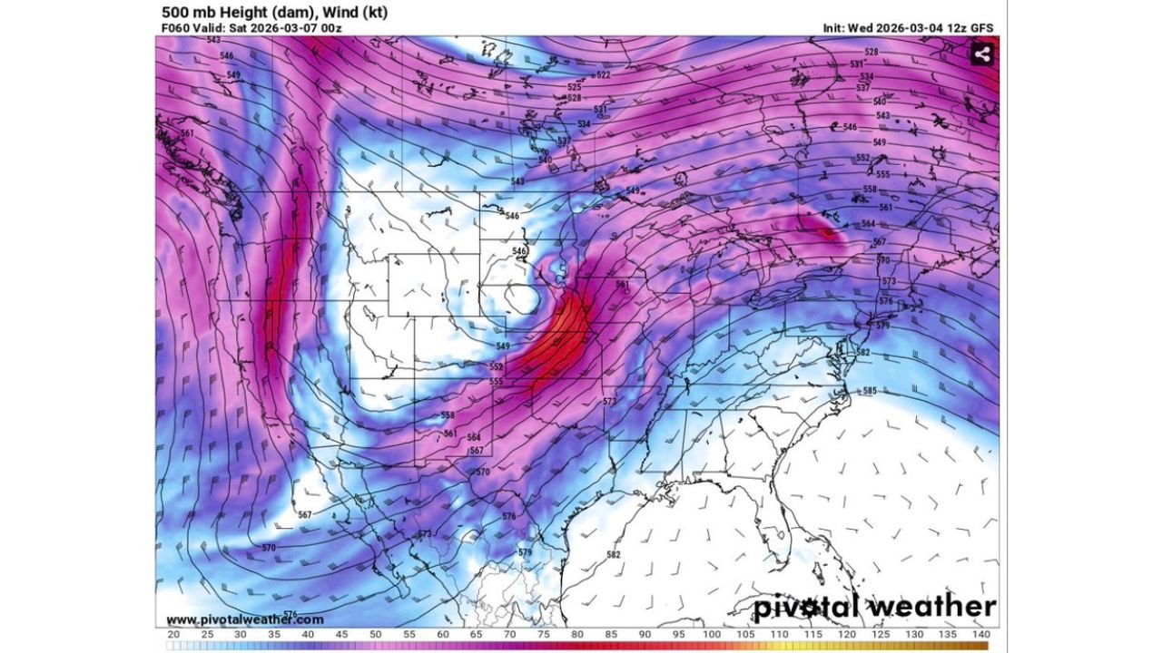
Weather data from upper-level atmospheric models shows a strong trough digging into the western United States while a powerful jet stream streak races across the Plains and Midwest.
The jet stream winds — measured around 500 millibars in the mid-levels of the atmosphere — appear extremely strong as they sweep from the Southern Plains through Missouri, Illinois, and toward the Great Lakes.
Strong mid-level winds are a major ingredient for severe storms because they help thunderstorms rotate and organize into long-lived storm structures such as supercells and squall lines.
Meteorologists often watch these jet streaks carefully because they can dramatically increase storm intensity once surface storms begin forming.
Gulf Moisture Surging Into the Midwest
Another key factor visible in forecast data is a surge of warm, humid air moving north from the Gulf of Mexico.
Moisture values across parts of the Midwest appear unusually high for early March, with temperatures and humidity spreading across states including:
- Missouri
- Illinois
- Indiana
- Kentucky
- Iowa
- Wisconsin
Temperature readings across this region are forecast to climb into the mid-50s across Iowa and Wisconsin, while warmer air in the low-60s spreads across Missouri, Illinois, and surrounding states.
This combination of warm, moist surface air and strong winds above creates the classic environment for severe thunderstorms.
Upper-Level System Moving Inland Could Trigger Storm Development
Meteorologists say the developing storm system moving inland from the western United States is the driving force behind this potential outbreak.
As the system advances eastward, it is expected to strengthen the jet stream across the Plains and Midwest while pulling moisture northward from the Gulf.
When these ingredients collide along the advancing cold front, thunderstorms may rapidly intensify across the region.
The exact timing and storm track will depend on how quickly the upper-level system evolves over the next couple of days.
Midwest Could See Widespread Storm Activity
If current model projections verify, thunderstorms could impact a large area stretching from Missouri and Illinois into Iowa, Wisconsin, and possibly parts of Minnesota and Michigan.
Potential hazards could include:
- Damaging wind gusts
- Large hail
- Heavy rainfall
- Possible tornado development in stronger rotating storms
The developing setup has drawn attention because early March typically sees fewer large-scale severe weather outbreaks this far north.
However, strong spring-like patterns sometimes emerge early in the season when Gulf moisture surges northward.
Forecast Models Still Being Refined
Despite the strong signals in current weather models, meteorologists emphasize that forecast adjustments are still likely.
Computer models such as the GFS and other global forecasting systems continue to analyze the storm’s track and strength, meaning the exact locations of the most intense storms could shift over the next day or two.
Forecasters say confidence should improve as new model runs become available.
WaldronNews Will Continue Monitoring the Developing System
With the storm system still evolving, residents across the Midwest and central United States should stay alert for forecast updates.
WaldronNews will continue tracking the developing severe weather pattern, including updated storm timing, potential impacts, and safety information as meteorologists refine their forecasts.
Stay connected with WaldronNews.com for the latest severe weather updates and regional forecasts as this powerful storm system approaches the Midwest.