
Powerful Winter Storm Expected to Impact Upper Midwest, Great Lakes, and Northeast With Heavy Snow, Blizzard Conditions, Ice, and Dangerous Cold Sunday Into Monday
WALDRON, INDIANA — A significant, multi-hazard winter storm is expected to develop across the Upper Midwest, Great Lakes, and Northeast beginning Sunday and continuing into Monday, bringing a dangerous combination of heavy snow, blizzard conditions, treacherous ice accumulation, high winds, and bitterly cold wind chills, according to national forecast guidance.
Forecasters say the storm will rapidly intensify as it tracks through the Great Lakes, spreading multiple winter hazards from the Northern Plains eastward through New England, with travel conditions expected to deteriorate quickly across several states.
Storm Timeline and Overall Setup
The winter storm is forecast to begin impacting the region late Sunday, strengthening overnight and persisting through Monday and Monday night.
- Upper Midwest: Late Sunday into Monday
- Great Lakes: Sunday night through Monday
- Interior Northeast and New England: Sunday afternoon through Monday night
The storm’s strength and speed will allow multiple hazards to occur simultaneously, making this a particularly dangerous setup.
Heavy Snow and Blizzard Conditions Expected
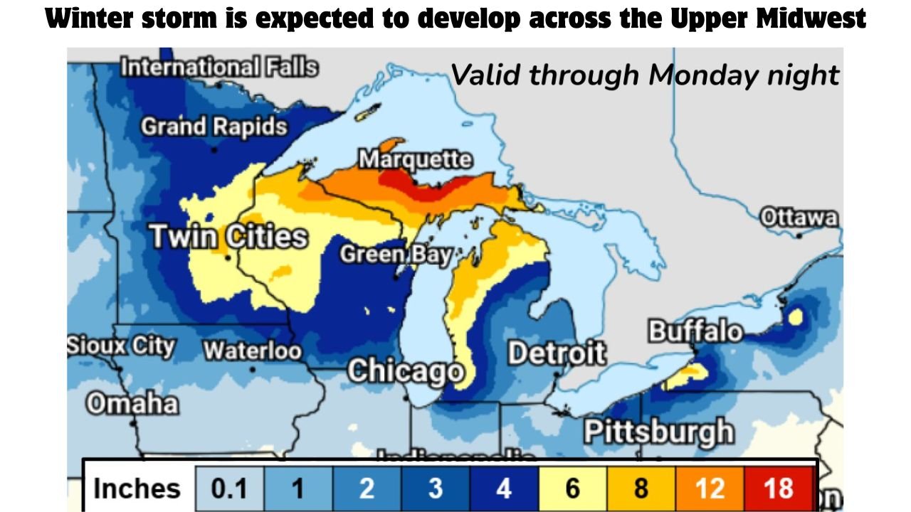
The most severe snow impacts are expected across the Upper Midwest and Upper Great Lakes, where prolonged snowfall and strong winds will combine to create blizzard or near-blizzard conditions.
Key snowfall concerns include:
- Over a foot of lake-enhanced snow possible in parts of Michigan’s Upper Peninsula
- Heavy snow spreading across northern Minnesota, northern Wisconsin, and western Michigan
- Blowing and drifting snow reducing visibility to near zero at times
Dangerous travel conditions and scattered power outages are likely in areas experiencing the heaviest snowfall and strongest winds.
Hazardous Ice Accumulation in the Northeast
Before changing to snow, parts of the interior Northeast are expected to see a wintry mix with freezing rain, increasing the risk for ice-related damage.
Forecast highlights include:
- More than 0.25 inches of ice possible in parts of New York, Vermont, New Hampshire, and Maine
- Freezing spray and icy conditions along northern shores of Wisconsin and Michigan
- Slick, treacherous roads and localized power outages
Ice accumulation combined with wind will significantly increase the risk for downed trees and power lines.
Strong Winds and Bitterly Cold Wind Chills
In addition to snow and ice, the storm will bring powerful winds and dangerous cold.
- Wind gusts over 40 mph expected across large portions of the storm area
- Blizzard conditions likely where heavy snow and strong winds overlap
- Arctic air spilling southward will drive wind chills well below zero
Forecasters warn that wind chills as cold as -30°F are possible in parts of North Dakota and northern Minnesota, posing a serious risk of frostbite in a short amount of time.
Most Impacted Regions
The highest-impact areas include:
- Upper Midwest: Northern Minnesota, Wisconsin, Michigan
- Great Lakes: Michigan, northern Indiana, northern Ohio
- Interior Northeast: Upstate New York, Vermont, New Hampshire, Maine
Travel disruptions are expected across interstates, secondary roads, and regional airports.
Safety and Preparedness Guidance
Residents across the affected regions are urged to:
- Avoid unnecessary travel during peak storm conditions
- Prepare for power outages and limited emergency response times
- Have winter survival kits ready for vehicles
- Dress in layers and limit outdoor exposure during extreme cold
Because multiple hazards will overlap, conditions may become dangerous faster than expected.
Bottom Line
A powerful late-December winter storm will impact the Upper Midwest, Great Lakes, and Northeast from Sunday into Monday, bringing heavy snow, blizzard conditions, hazardous ice, damaging winds, and dangerously cold wind chills. Widespread travel disruptions, power outages, and dangerous conditions are likely across several states.
Residents should closely monitor updates and take this storm seriously as it develops.
Stay with WaldronNews.com for continued coverage, updates, and any watches or warnings issued as the storm approaches.