
Powerful Winter Storm to Slam Washington, Montana, North Dakota, and Minnesota With Blizzard Conditions and Damaging Winds
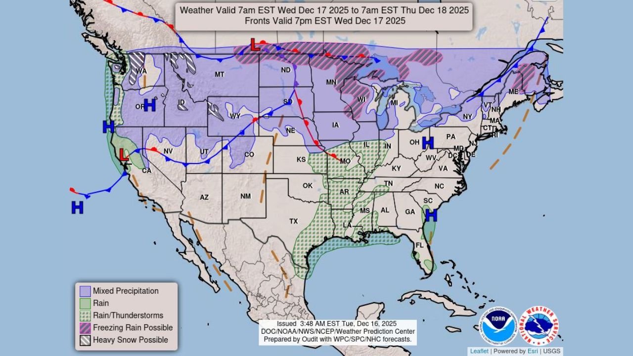
MONTANA — A powerful and fast-moving winter storm is expected to sweep from the Pacific Northwest into the Northern Plains and Great Lakes between Wednesday and Thursday, bringing blizzard conditions, heavy mountain snow, low-elevation rain, and dangerous wind gusts across several states, according to federal weather guidance and high-resolution model data.
Weather maps and official alerts show widespread high-wind warnings, with blizzard conditions expected in Washington’s Olympic Mountains and Cascades, while snow and wind impacts expand into Montana, North Dakota, and Minnesota as the storm strengthens and shifts east.
“This is a high-impact, multi-hazard winter storm with wind being a major concern across multiple regions,” forecasters noted in briefing materials.
Blizzard Conditions Expected in Washington’s Olympic Mountains and Cascades
The most severe winter conditions are expected in western Washington, where blizzard warnings and winter weather advisories are already in place for the Olympic Mountains and Cascade Range.
Snowfall combined with strong winds will significantly reduce visibility, creating whiteout conditions in higher elevations.
“Blizzard conditions are expected in the Washington Olympics and Cascades Wednesday,” forecasters warned.
Low-elevation areas across western Washington are expected to see heavy rain, increasing the risk of localized flooding, while mountain passes may become impassable due to snow and blowing snow.
Northern Plains Face Snow and Intensifying Winds Wednesday Night Into Thursday
As the storm moves east, snow and wind impacts increase across Montana and North Dakota, with blizzard conditions possible in parts of the Northern Plains late Wednesday night into Thursday.
Weather prediction center maps highlight a broad swath of heavy snow potential, particularly across northern Montana and North Dakota, where strong pressure gradients will drive sustained winds and gusts capable of creating blowing and drifting snow.
“Blizzard conditions are possible in the Northern Plains Wednesday night into Thursday as snowfall combines with high winds,” federal forecasters stated.
Travel across rural highways and open terrain could become dangerous or impossible, especially overnight.
High Wind Warnings Stretch From the Pacific Northwest Into the Plains
One of the most widespread threats from this storm is damaging wind.
Wind advisory and warning maps show high wind warnings and watches extending from Washington and Oregon eastward into Montana and the Dakotas. Model guidance indicates wind gusts strong enough to cause power outages, downed trees, and hazardous travel, particularly for high-profile vehicles.
“Low elevation rain and mountain snow will combine with high winds resulting in widespread impacts,” the Weather Prediction Center noted.
Wind gusts will remain strong even outside snow-covered areas, meaning wind damage may occur well beyond the heaviest snowfall zones.
Midwest and Great Lakes Prepare for Snow and Wind Impacts
By late Wednesday into Thursday, the storm is expected to reach the Upper Midwest and Great Lakes, including Minnesota, where snow, gusty winds, and rapidly changing road conditions are anticipated.
While snowfall totals may vary, the combination of snow and strong winds could still produce near-blizzard conditions in exposed areas, especially in open farmland and along major corridors.
Drivers across the region should prepare for rapid deterioration in travel conditions as the system moves through.
What Residents Should Prepare For
Officials urge residents across impacted states to prepare for:
- Blizzard and whiteout conditions in mountain and Northern Plains regions
- High wind damage, including power outages and fallen trees
- Hazardous travel, especially overnight and early morning hours
- Rapid weather changes as the storm shifts east
“This storm carries multiple hazards — snow, wind, and rain — and impacts may escalate quickly,” forecasters cautioned.
WaldronNews.com Weather Alert
Residents across Washington, Montana, North Dakota, and Minnesota should continue monitoring local National Weather Service alerts, especially if travel is planned during the Wednesday–Thursday timeframe.
Conditions may evolve rapidly as the storm strengthens and shifts east.
For continued updates, regional impacts, and safety guidance, follow WaldronNews.com.