
Rapid-Hitting Snowstorm to Slam New York and Connecticut With 2–3 Inch-Per-Hour Snowfall Rates Friday Evening
NEW YORK — A rapidly intensifying winter storm is expected to sweep into the region Friday evening, bringing a short-duration but extremely intense burst of snowfall that could quickly overwhelm roads and make travel hazardous across parts of New York and Connecticut.
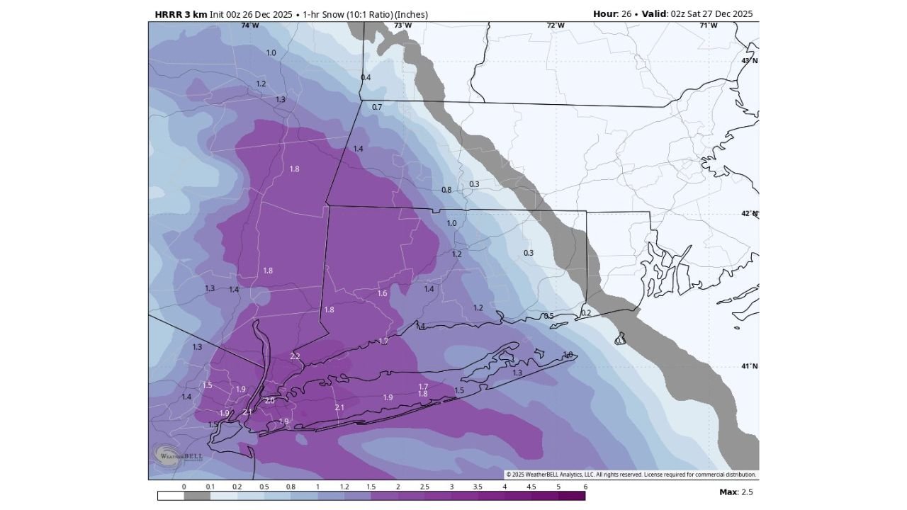
Forecast data and high-resolution model guidance show the Hudson Valley, Western Connecticut, and Central Connecticut taking the brunt of the storm’s initial snow band, with snowfall rates potentially reaching 2 to 3 inches per hour during the peak of the event.
Snow Arrives Quickly Friday Evening
Unlike long-duration winter storms, this system is expected to ramp up rapidly, delivering most of its snowfall in just a few hours.
According to high-resolution HRRR model guidance, snow is projected to begin around 5 p.m. Friday, with conditions deteriorating quickly through the evening commute. By 10 p.m., some locations could already have around 6 inches of snow on the ground, even though the storm itself may not last much longer overnight.
Meteorologists note that the majority of accumulation will occur during the first few hours, making timing a critical factor for anyone traveling.
Heaviest Snow Focused on Hudson Valley and Connecticut
Model snowfall maps indicate the strongest snow band setting up across:
- Hudson Valley, New York
- Western Connecticut
- Central Connecticut
Within this corridor, snowfall rates near or above 2 inches per hour are possible for a time, especially during the evening. Lighter totals are expected eastward toward coastal New England, where snow intensity drops off more quickly.
This sharp gradient means that small changes in location could lead to big differences in snowfall, but confidence is growing that inland areas of New York and Connecticut will see the most significant impacts.
Travel Conditions Could Deteriorate Rapidly
Because snow will fall so quickly, road crews may struggle to keep up during the heaviest bands. Visibility could drop significantly during peak snowfall, and untreated roads may become snow-covered in minutes.
Drivers heading out Friday evening should be prepared for:
- Rapidly worsening road conditions
- Reduced visibility during heavy snow bursts
- Slower-than-normal travel even on major highways
Officials urge caution for anyone who must be on the roads during the evening hours, especially during the peak snowfall window.
Short Storm, High Impact
While this is not expected to be a long-lasting storm, its intensity and timing make it particularly disruptive. The combination of high snowfall rates, evening arrival, and quick accumulation increases the risk for travel-related issues despite the storm’s brief duration.
Residents in affected parts of New York and Connecticut are advised to plan ahead, avoid unnecessary travel Friday evening if possible, and allow extra time if driving is unavoidable.
What to Watch Next
Forecasters will continue monitoring the exact placement of the heaviest snow band, as even a slight shift could change local totals. Updates may refine snowfall expectations, but confidence remains high that Friday evening will be the most dangerous period of this event.
WaldronNews.com will continue tracking this storm and provide updates as conditions develop.