
Rare February Severe Weather Threat Targets Ohio Valley Including Indiana, Ohio and Kentucky on Thursday, Feb. 19
UNITED STATES — A rare February severe weather setup is taking shape across the Ohio Valley, with parts of Indiana, Ohio, and Kentucky highlighted for strong to potentially severe thunderstorms on Thursday, February 19.
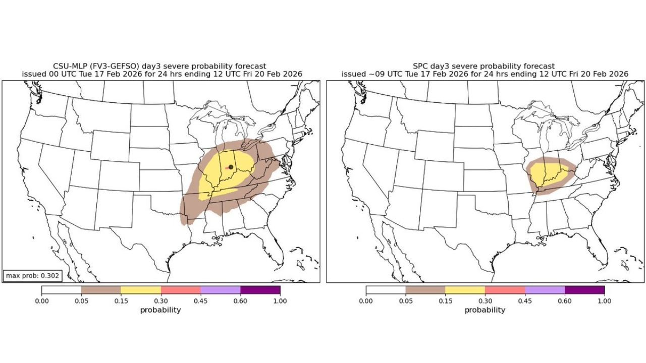
Forecast outlook graphics show a focused risk corridor stretching from central and southern Indiana into western and central Ohio and northern Kentucky, where atmospheric conditions may support large hail, damaging winds, and even a couple of tornadoes if instability trends upward.
Severe Risk Zone Centered Over Indiana and Ohio
The latest severe probability outlook places a concentrated area of concern across:
- Indianapolis, IN
- Dayton and Columbus, OH
- Cincinnati, OH
- Louisville, KY
- Surrounding communities across the lower Great Lakes and Ohio Valley
A broader marginal risk extends outward into parts of Illinois, western Pennsylvania, West Virginia, and western New York, but the higher-end probabilities remain centered over the heart of Indiana and Ohio.
While February severe weather is not unheard of, it is far less common than springtime outbreaks. That alone makes this system notable.
What’s Driving This Setup?
Forecast discussions indicate a surface low pressure system moving across the Ohio Valley, with a strengthening jet stream overhead. That upper-level energy will help enhance lift and wind shear — two key ingredients for organized thunderstorms.
However, one important factor remains uncertain: moisture and instability.
If Gulf moisture can surge northward efficiently and temperatures rise enough during the afternoon, the environment could support:
- Supercell thunderstorms
- Large hail
- Isolated tornadoes
- Damaging straight-line winds
If instability underperforms, the severe threat would trend lower.
Timing: Thursday Afternoon into Evening
Current projections show the main window for strong storms developing:
- Mid to late afternoon Thursday
- Continuing through the early evening hours
- Gradually weakening later at night as the system moves east
Cities including Indianapolis, Columbus, Cincinnati, and Louisville could see storms during peak commuting hours, increasing potential impacts.
Residents across these areas should monitor forecast updates closely, especially if watches or warnings are issued later in the week.
Confidence Level and What Could Change
At this range, forecasters emphasize that small shifts in moisture return and instability levels could significantly alter the final outcome.
Key uncertainties include:
- How far north richer moisture can advance
- Whether cloud cover limits daytime heating
- Exact placement of the surface low and frontal boundaries
These variables will determine whether the event remains a strong thunderstorm setup or escalates into a more organized severe weather day.
Why This Is Unusual for February
Severe thunderstorm setups of this nature are more typical in March through May. February events often struggle with limited instability. However, when strong jet dynamics and surface lows align properly — as models suggest — impactful storms can still occur.
That is why this event is being labeled as a rare February severe weather threat across the Ohio Valley.
What Residents Should Do Now
- Stay weather-aware through Thursday
- Have multiple ways to receive warnings
- Review tornado safety plans if you live in the highlighted risk area
- Secure outdoor items ahead of potential gusty winds
This is not yet a guaranteed high-end outbreak, but the ingredients are present for a few strong to severe storms.
WaldronNews.com will continue monitoring forecast updates and model trends as Thursday approaches. Check back for the latest developments affecting Indiana, Ohio, Kentucky, and surrounding Ohio Valley communities.