
Rare February Severe Weather Threat Targets Ohio Valley With Tornado Risk From Indiana to Kentucky on Thursday
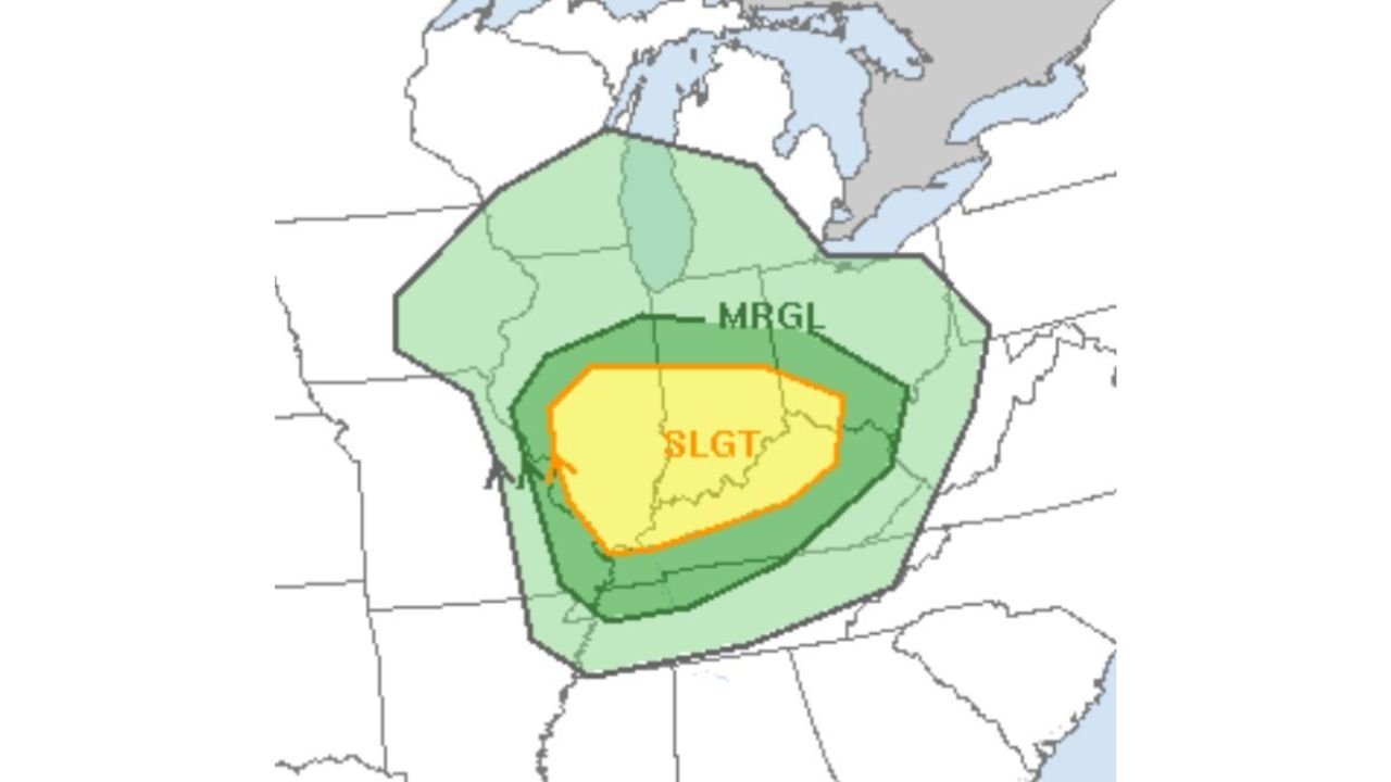
UNITED STATES — A rare February severe weather setup is taking shape across the Ohio Valley for Thursday, with the Storm Prediction outlook highlighting a Slight Risk (Level 2 of 5) centered over parts of Indiana, Kentucky, and Ohio.
This type of organized severe threat is uncommon for mid-to-late February in this region, and forecasters say all modes of severe weather — including tornadoes — are possible Thursday afternoon and early evening.
Slight Risk Centered Over Indiana, Kentucky, and Ohio
The outlook places the core Slight Risk area over:
- Central and southern Indiana
- Northern and central Kentucky
- Western and central Ohio
Cities within or near the highlighted zone include:
- Indianapolis, IN
- Louisville, KY
- Cincinnati, OH
- Dayton, OH
- Portions of Columbus, OH
A broader Marginal Risk surrounds the Slight Risk area, extending into:
- Southern Illinois
- Northern Tennessee
- Western West Virginia
- Parts of Michigan
Tornadoes Possible if Instability Holds
Forecasters emphasize that tornado potential will depend heavily on how much moisture and instability can develop ahead of the system.
Key factors being monitored include:
- Gulf moisture return northward into the Ohio Valley
- Surface-based instability levels Thursday afternoon
- Strength of low-level wind shear
If moisture and instability remain high enough, discrete storms could form ahead of the main line — increasing the tornado risk.
If instability underperforms, the threat may lean more toward:
- Damaging straight-line winds
- Large hail
- Brief, weaker tornadoes embedded in lines
Timing: Afternoon Through Early Evening
Current projections suggest:
- Storm development begins Thursday afternoon across southern Illinois and western Indiana.
- Stronger storms move into central Indiana and northern Kentucky by late afternoon.
- The system shifts east into Ohio during the early evening hours.
The window for the most significant severe weather appears to be from mid-afternoon through early nighttime hours.
Why This Is Notable for February
Severe weather events are less common this far north in February, but they are not unprecedented.
When strong wind dynamics overlap with returning Gulf moisture, late-winter severe outbreaks can occur in the Ohio Valley.
This system features:
- Strong upper-level support
- A sharpening surface low
- Increasing wind shear
The remaining uncertainty revolves around thermodynamics — specifically how unstable the atmosphere becomes ahead of the advancing front.
Threat Could Uptrend or Downgrade
Forecast confidence is moderate, but adjustments are likely over the next 24–48 hours.
The threat could:
- Increase if moisture and instability trend higher.
- Decrease if cloud cover limits heating or moisture return is weaker than expected.
Residents across Indiana, Kentucky, and Ohio should closely monitor forecast updates Wednesday and Thursday morning as higher-resolution models refine storm details.
What Residents Should Do
Those in the Slight Risk area should:
- Review tornado safety plans.
- Ensure multiple ways to receive warnings.
- Be prepared for rapidly changing conditions Thursday afternoon and evening.
Even in February, severe storms can develop quickly and intensify fast when conditions align.
WaldronNews.com will continue tracking this developing Ohio Valley severe weather setup and provide updated analysis as newer data becomes available.