
Rare Forecast Shows a Small Chance of Snowflakes Across West-Central Florida This Weekend, but Accumulation Is Unlikely
UNITED STATES — In an unusual winter forecast for the Deep South, meteorologists are highlighting a low but non-zero probability of snowfall across parts of west-central Florida this weekend, according to NOAA Global Systems Laboratory probability guidance valid through Sunday evening, February 1, 2026.
While the idea of snow in Florida is striking, forecasters stress that any snow that does fall would likely be brief, light, and largely non-accumulating, due to warm ground temperatures and marginal atmospheric support.
What the Probability Map Shows
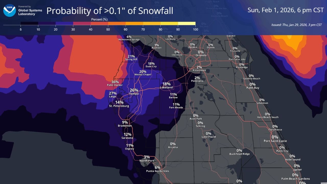
The official NOAA probability map illustrates the chance of receiving more than 0.1 inches of snowfall, not a guaranteed outcome.
Key probabilities across west-central Florida include:
- Palm Harbor: up to 36%
- Largo: around 27%
- Tampa: near 26%
- Wesley Chapel and Spring Hill: roughly 20–21%
- Lakeland: around 18%
- St. Petersburg: approximately 14%
- Bradenton, Sarasota, and Osprey: generally 9–12%
Inland and east-central Florida locations, including Orlando, Kissimmee, Sebring, Lake Placid, and the Space Coast, show near-zero probability.
Why Snow Is Possible but Accumulation Is Not
Forecasters emphasize that probability does not equal impact.
Even if light snow showers develop:
- Soil temperatures remain too warm for snow to stick
- Any flakes would likely melt on contact
- Accumulation would be near zero for almost all locations
This setup suggests the potential for brief flurries or snow grains, rather than a measurable winter event.
Why This Forecast Is So Unusual
Snowfall probabilities of this magnitude in Florida are extremely rare, especially this far south.
The forecast reflects:
- A strong Arctic air mass pushing deep into the Southeast
- Unusual upper-level cold for late January
- A narrow window where moisture and cold briefly overlap
Even with those ingredients, the environment remains hostile to sustained snow accumulation.
What Residents Might Actually See
If conditions align just right, residents in west-central Florida could observe:
- Brief flurries or sleet-like pellets
- No accumulation on roads, grass, or rooftops
- A short-lived novelty rather than a disruptive event
Forecasters caution against expecting any meaningful impacts, despite the eye-catching nature of the forecast.
What This Means for Arkansas
While Arkansas is not part of this snowfall probability area, the forecast underscores the strength of the current winter pattern, capable of driving Arctic air far south into regions that almost never see snow.
Such patterns can remain volatile, and future systems could still influence the South-Central U.S. as winter continues.
Stay with WaldronNews for continued winter weather coverage, national pattern analysis, and updates on any changes that could affect Arkansas or the broader region.