
Rhode Island and Central Massachusetts Could See 4–6+ Inches as Narrow Snow Band Wobbles Toward Long Island, Connecticut, or Southeast Mass
UNITED STATES — A classic “fine-line” snow setup is taking shape across southern New England, and the newest guidance suggests the difference between a routine snowfall and a higher-impact burst could come down to one detail: where a narrow band of heavier snow sets up — and whether it shifts 25 miles east or west.
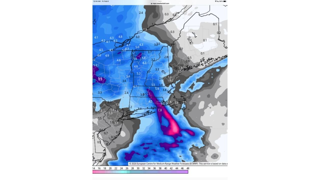
Right now, Rhode Island and central Massachusetts appear to be the early favorites for the higher totals, but the forecast notes this is the kind of pattern where a small adjustment in storm track can quickly move the jackpot zone into eastern Long Island and Connecticut — or shove it toward eastern and southeastern Massachusetts instead.
What’s driving the “narrow band” threat
The discussion points to a more pronounced 0z Euro (ECMWF) solution, enhanced by a nor’easter-style (nor’lun) feature. In these setups, snow doesn’t fall evenly across the region. Instead, you often get:
- A tight, organized stripe of heavier snow
- Sharp cutoffs where totals drop off fast just a few towns away
- A higher chance of “surprise” totals if the band stalls even briefly
That’s why this isn’t a simple “everyone gets the same amount” event.
Current favorites for higher totals: Rhode Island and central Massachusetts
As of this update, the guidance suggests the most likely corridor for stronger accumulation is:
- Rhode Island
- Central Massachusetts
In that zone, the forecast message says some communities could see 4–6 inches or more if the band holds long enough.
This is the area most likely to get the heavier snowfall rates if the band stays locked in place for a few hours.
The 25-mile shift that changes everything
This forecast comes with a big warning: a 25-mile shift is enough to move the heaviest snow into a different state.
Here’s what the guidance says:
- Shift 25 miles west: the heavier band pushes toward eastern Long Island (New York) into Connecticut
- Shift 25 miles east: the heavier band shifts into eastern to southeastern Massachusetts
That’s a major difference for commuters, plow planning, and even school or event decisions — because areas that miss the band could end up with “manageable” totals, while areas under it can get a quick, higher-impact burst.
Snow totals: 4–6+ inches in the band, 1–3 inches for most others
The snowfall expectation in this update is split clearly into two categories:
Under the heavier band (where it sets up):
- 4–6 inches+ possible
Outside the band (most locations):
- A general 1–3 inches
That means a lot of people will see what looks like a typical light-moderate snowfall — but a smaller region could end up with totals that feel like a completely different storm.
What residents should watch for in real time
Because the heavy snow zone is narrow and sensitive to storm track, the best approach is to watch for signs the band is forming and stabilizing.
Clues the heavier band is locking in near you:
- Snow intensity increases quickly from light flakes to thicker, steadier snowfall
- Visibility drops even without strong wind
- Roads go from “just wet” to snow-covered in a short time
- Nearby towns report totals rising faster than expected
If you’re in Rhode Island, central Massachusetts, eastern Long Island, Connecticut, or eastern/southeastern Massachusetts, you’re in the zone where that 25-mile wobble matters most.
Bottom line for this setup
This isn’t a “big blizzard for everyone” type of storm. It’s a band-driven snow event where the forecast is fairly confident that:
- Most areas see 1–3 inches
- A smaller corridor hits 4–6+ inches
- The exact location of that corridor can still shift east or west by about 25 miles
That’s why the “favorites” can change quickly — and why totals may look uneven across the region by the time this is over.
If you’re in the Northeast, where are you located — Rhode Island, Massachusetts, Connecticut, or Long Island — and are you already seeing steadier snow bursts? Share what you’re seeing and keep following updates on WaldronNews.com.