
Rhode Island and Southeast Massachusetts Hammered by 2–4” Per Hour Snow Bands as Blizzard of 2026 Delivers Widespread 18–24” Totals
SOUTHERN NEW ENGLAND — The Blizzard of 2026 is now firmly entrenched across Rhode Island and southeastern Massachusetts, where intense snowfall bands have been dumping snow at rates of 2 to 4 inches per hour since early this morning.
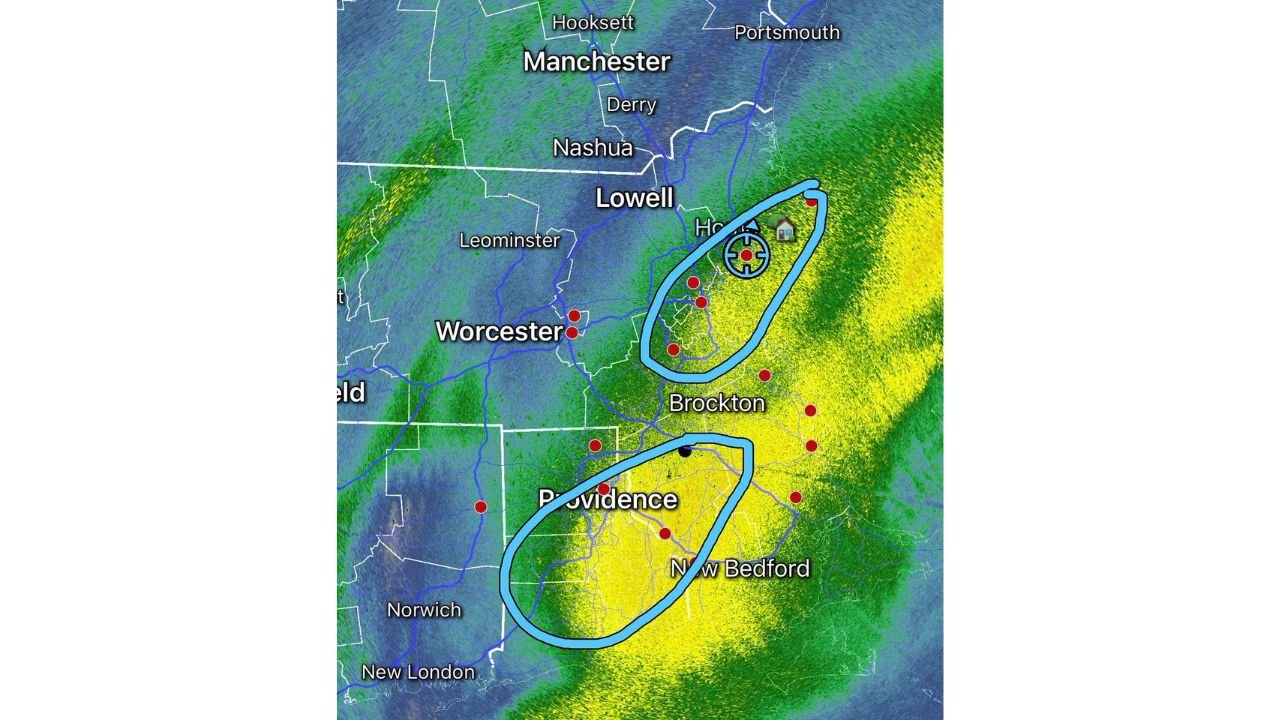
Radar imagery shows a powerful, nearly stationary band locked over Providence, New Bedford, Brockton, and surrounding communities — creating what forecasters are calling the clear “jackpot zone” of the storm.
Main Jackpot Zone: Providence to New Bedford
The heaviest snow is centered across:
- Providence and surrounding Rhode Island communities
- Bristol County, Massachusetts
- New Bedford
- Areas just south of Brockton
These locations have been sitting directly under the core deformation band, where snowfall rates have repeatedly reached 2–4 inches per hour.
At those rates, totals climb extremely fast — and travel becomes nearly impossible in short order.
Forecasters continue to project widespread 18–24 inches across this corridor, with localized higher amounts possible where the band lingers the longest.
Northeast Massachusetts Could See a Late Surge
While Rhode Island and southeast Massachusetts remain the primary jackpot area, northeastern Massachusetts may become a “sneaky mini-jackpot” region.
Communities near:
- Lowell
- Areas south of Manchester, New Hampshire
- Northeastern suburbs north of Boston
have been on the outer fringe of the main heavy band. As the band pivots later today, these areas could rotate into more persistent heavy snow, potentially boosting totals significantly.
Blizzard Conditions Ongoing
Blizzard conditions continue across much of the region, particularly where heavy banding overlaps with strong winds.
Impacts include:
- Near-zero visibility during peak snowfall
- Rapid road coverage
- Significant drifting
- Extremely hazardous travel
With snow rates reaching 2–4 inches per hour in the heaviest bands, plowing operations are struggling to keep pace.
Sharp Gradient to the West
A noticeable cutoff exists west of the main band.
Areas closer to Worcester and parts of interior Massachusetts are seeing lighter snowfall compared to the intense core stretching from Providence to the South Shore.
This sharp gradient highlights just how focused and powerful the deformation band has become.
Still Expecting 18–24 Inches Region-Wide
Despite some localized variations, forecasters continue to call for widespread 18–24 inch totals across much of Rhode Island and southeastern Massachusetts.
Given the ongoing banding and potential for additional pivoting, some communities could exceed those projections before the storm begins to wind down.
Bottom Line
Rhode Island and southeastern Massachusetts remain in the bullseye of the Blizzard of 2026, with intense 2–4 inch per hour snowfall rates producing rapid accumulation and dangerous whiteout conditions.
Northeastern Massachusetts may still see a late push of heavy snow as the band pivots, while blizzard conditions continue across the hardest-hit zones.
Residents are urged to stay off the roads and continue monitoring official updates as this historic winter storm unfolds.
WaldronNews.com will provide further updates as conditions evolve.