
Rotating Supercells With Baseball Sized Hail and EF2 Tornadoes Likely Monday Across Minnesota and Wisconsin as Supercell Zone Locks in Between Watertown, Minneapolis and Green Bay
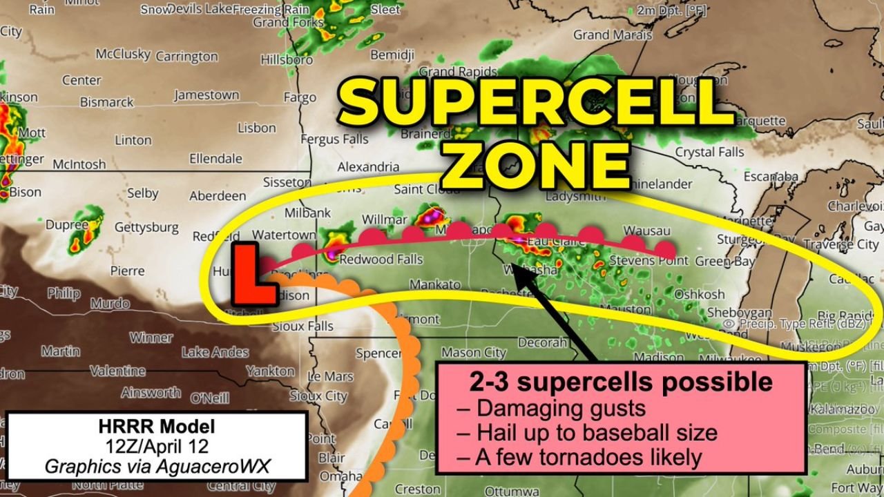
MINNEAPOLIS, Minnesota — A locally significant and potentially violent severe weather episode is locked in for Monday, April 13 across Minnesota, Wisconsin, and northern Iowa, as a low pressure center near Brookings, South Dakota lifts a powerful warm front northward — triggering 2 to 3 rotating supercells capable of producing baseball-sized hail, damaging wind gusts, and a few tornadoes including an isolated significant EF2+ tornado directly over the Watertown to Minneapolis to Green Bay corridor.
This is not a widespread outbreak — but that does not make it less dangerous. Only a couple of storms are expected to form, but the ones that do will be intense, well-organized, and capable of producing all severe hazards simultaneously as they track through some of the most populated communities in the Upper Midwest.
The Supercell Zone — Who Is Directly in the Crosshairs
The Supercell Zone identified for Monday afternoon and evening runs directly through:
- South Dakota: Watertown and the eastern South Dakota corridor near the low pressure center where warm front lifting begins
- Minnesota: Redwood Falls, Willmar, Minneapolis, St. Paul, Mankato, and the broader Twin Cities metro sit directly inside Monday’s supercell zone — Minneapolis residents are being specifically urged to park vehicles in garages or under carports
- Wisconsin: Green Bay, Wausau, Stevens Point, Oshkosh, Sheboygan, and the broader eastern Wisconsin corridor are inside the supercell zone as storms track northeast along the warm front
- Northern Iowa: Mason City and the northern Iowa communities fall within the southern edge of Monday’s threat corridor
What 2 to 3 Supercells Actually Mean for Minnesota and Wisconsin
The number of storms expected Monday is small — but the quality of those storms is the concern. Here is exactly what 2 to 3 supercells operating in Monday’s atmospheric environment are capable of delivering:
Baseball-Sized Hail — A Direct Threat to Minneapolis: Dry air sitting at the mid-levels of the atmosphere on Monday is creating ideal hail growth conditions. When supercooled water droplets encounter this dry mid-level air, they stick aggressively onto growing hailstones — making them larger and larger before they fall. Combined with temperatures dropping rapidly with altitude, Monday’s storms have the physical ingredients needed to grow baseball-sized hail — roughly 2.75 inches in diameter. A single baseball-sized hailstone falling at terminal velocity can shatter windshields, punch through roofing materials, and cause serious injury to anyone caught outdoors. Minneapolis residents specifically are being urged to get vehicles under cover before Monday afternoon.
EF2+ Tornado Possible — Warm Side of the Front: Supercells developing on the warm side — south — of the warm front will carry the tornado threat Monday. If any supercell can latch onto the warm front boundary, it will immediately absorb additional low-level helicity — the atmospheric spin that drives tornado production — and rotate even more aggressively than it already would in the base environment. This front-latching scenario is explicitly identified as the mechanism that could produce an isolated significant EF2 or stronger tornado somewhere along the warm front corridor from Watertown through Minneapolis toward Green Bay.
Damaging Wind Gusts: Even supercells that do not produce tornadoes will carry the threat of damaging straight-line wind gusts capable of downing trees and power lines across the supercell zone.
Why This Setup Is Particularly Dangerous Despite Being Small Scale
The fact that only 2 to 3 supercells are expected on Monday might seem reassuring — but experienced severe weather forecasters know that a small number of intense, discrete supercells in a high-shear, high-instability environment is often more dangerous than a widespread squall line. Discrete supercells are organized, long-lived, and capable of maintaining severe weather production for extended periods as they track across the landscape.
The warm front lifting northward from Brookings is the critical boundary Monday. Supercells that develop along this front will be operating in an environment where low-level helicity increases dramatically right at the frontal boundary — exactly the scenario where tornado production becomes most likely and most violent. If a supercell latches onto this boundary and rides it northeast toward Minneapolis and Green Bay, it will have a continuous supply of atmospheric spin to work with for as long as it stays near the front.
The mid-level dry air that is making hail growth so favorable on Monday is also a factor in tornado production — dry mid-level air increases the temperature contrast within storms, strengthening updrafts and making the overall storm structure more organized and dangerous.
Not Widespread — But Locally Catastrophic Where Storms Track
The forecast is clear on one important distinction — Monday’s event will not be widespread. Large portions of Minnesota and Wisconsin may see nothing more than clouds or light rain while communities directly under a supercell track experience violent and life-threatening severe weather. This is the most difficult type of severe weather event for residents to prepare for because the specific storm tracks will not be known until storms actually develop Monday afternoon.
Every community between Watertown and Green Bay — including the entire Twin Cities metro area — needs to treat Monday as a potential direct hit day and be fully prepared with shelter plans, vehicle protection, and active warning monitoring, because the difference between a direct supercell hit and a near-miss could be measured in just a few miles.
What to Do Before Monday Afternoon Arrives
- Minneapolis residents — get every vehicle into a garage or under a carport before Monday afternoon — baseball-sized hail will cause catastrophic and uninsurable damage to any vehicle left outdoors
- Identify your lowest-floor interior shelter room in your home now — if an EF2 tornado warning is issued for your county, you need to already be moving toward that room, not searching for it
- The Watertown to Minneapolis to Green Bay corridor is the explicit supercell zone — every resident in this area should have weather alerts active on all devices Monday
- Monitor NWS Twin Cities updates — the 5 AM Monday morning forecast discussion will be critical for understanding exactly where the warm front is expected to stall and which communities face the greatest direct threat
- Do not wait for sirens — by the time outdoor sirens activate, a supercell may already be within striking distance. Be inside and monitoring alerts actively before 3 PM Monday
- Northern Iowa residents near Mason City should monitor Monday afternoon conditions closely as the southern edge of the supercell zone could extend into this area depending on warm front position
Monday’s severe weather will be focused, intense, and locally catastrophic where supercells track. The Twin Cities, Green Bay, and the warm front corridor from Watertown east through Wisconsin are in the direct line of what could be a significant and violent severe weather episode — and every resident in that zone needs to be fully prepared before Monday afternoon arrives.
WaldronNews.com will continue tracking Monday’s supercell threat across Minnesota, Wisconsin, and northern Iowa and will provide updates as storm development and warm front positioning become clearer through Monday morning.