
Round After Round of Severe Storms Possible Across Oklahoma, Texas, Arkansas, Missouri, Tennessee and Kentucky as March Pattern Turns Active
UNITED STATES — A growing signal in long range machine learning guidance is pointing toward multiple rounds of severe weather developing across the southern Plains and lower Mississippi and Ohio Valleys beginning next week, with the strongest corridor stretching from Texas and Oklahoma through Arkansas, Missouri, Tennessee and Kentucky.
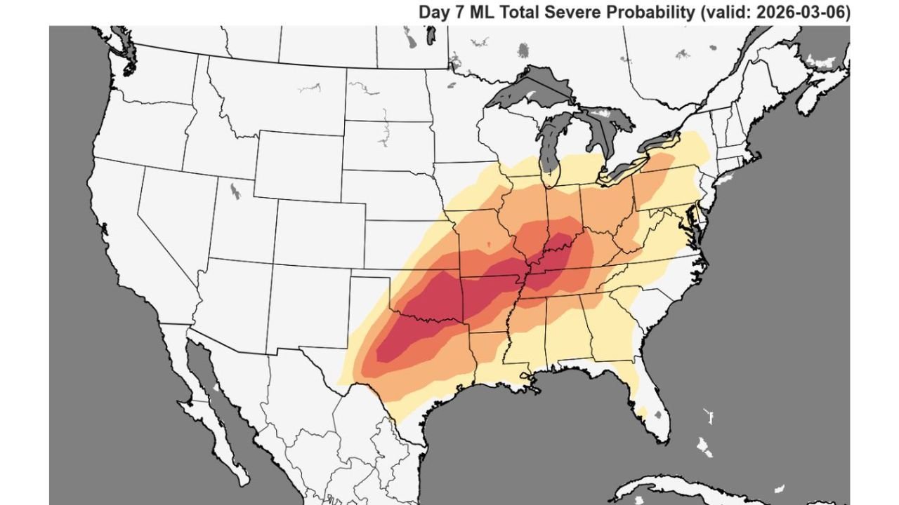
The Day 7 machine learning total severe probability map valid March 6, 2026 shows an expanding swath of elevated severe potential from central Texas northeastward into the Mid South and lower Ohio Valley.
States Showing the Strongest Signal
The highest probabilities currently focus on:
- Central and eastern Texas
- Southern and eastern Oklahoma
- Arkansas
- Missouri
- Western Tennessee
- Western Kentucky
The core of the strongest signal appears centered from northeast Texas through Arkansas into southeast Missouri and western Tennessee, where deeper red shading suggests the greatest overlap of ingredients.
Broader Risk Extends Beyond the Core
A wider area of lower but notable probabilities extends into:
- Louisiana
- Mississippi
- Alabama
- Illinois
- Indiana
- Ohio
- Portions of Pennsylvania and surrounding Mid Atlantic states
This suggests the pattern may not be a single day event, but rather a multi day stretch of unsettled and potentially stormy conditions shifting east over time.
What the Pattern Indicates
The guidance highlights a classic southwest to northeast oriented corridor, often associated with:
- Strong upper level energy ejecting from the Southwest
- Increasing Gulf moisture return into Texas, Arkansas and Tennessee
- Strengthening wind shear supportive of organized thunderstorms
While exact storm modes and hazards remain uncertain at this distance, this type of setup typically favors:
- Damaging straight line winds
- Large hail
- Isolated tornado potential, especially in the stronger instability corridor
Why This Matters for Arkansas
For communities across western Arkansas and the Arkansas River Valley, including areas near Waldron and surrounding Scott County, this pattern bears watching closely.
Arkansas sits near the center of the highlighted corridor, particularly for the March 6 timeframe, meaning:
- Storms could organize before moving northeast.
- Multiple rounds are possible rather than a single isolated event.
- Confidence in an active pattern is increasing, even if exact impacts remain several days out.
Still Early, But Trends Are Increasing
It is important to emphasize that Day 7 outlooks represent early signals, not finalized forecasts. However, when machine learning guidance consistently highlights the same corridor several days out, it often indicates that large scale atmospheric ingredients are aligning.
Forecast details such as:
- Exact timing
- Tornado potential
- Storm coverage
- Rainfall amounts
will become clearer as the event approaches.
Bottom Line
An increasingly active severe weather pattern may take shape next week across Texas, Oklahoma, Arkansas, Missouri, Tennessee and Kentucky, with Arkansas positioned near the heart of the projected corridor for March 6.
Residents across western Arkansas should begin reviewing severe weather safety plans and stay tuned for updated forecasts as confidence grows in the coming days.
WaldronNews.com will continue to monitor developments and provide updates specific to Scott County and surrounding Arkansas communities as this evolving severe weather pattern becomes clearer.