
Saturday Clipper Snow Track Wobbles South Across Minnesota and Wisconsin, Leaving Minneapolis–St. Paul Forecast in Flux With 2–4 Inches Possible
MINNESOTA — Forecast models are showing shifting trends with Saturday’s incoming Clipper system, and the latest guidance suggests the narrow snow band may be edging slightly farther south — a move that could reduce totals in parts of the Twin Cities metro.
Several model runs overnight have trended the primary snow corridor southward, introducing uncertainty into how much accumulation Minneapolis–St. Paul (MSP) ultimately sees.
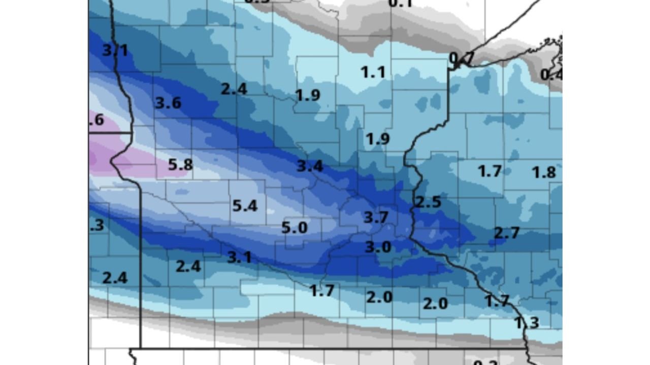
Snow Band Focused Across Southern Minnesota Into Wisconsin
The snowfall map shows a narrow but defined stripe of accumulation stretching from western Minnesota eastward into Wisconsin.
Projected totals currently include:
- 3–4 inches near the Twin Cities
- Around 3.7 inches in portions of central Minnesota
- 3.0 inches in southern Minnesota
- 2–3 inches across western Wisconsin
- Lighter amounts (1–2 inches) north of the main band
Higher totals, in the 5–6 inch range, appear just west and southwest of the core metro area in parts of southwestern Minnesota — highlighting how tight and sensitive this gradient is.
If the southward trend continues, the heaviest band could shift just enough to trim totals in Minneapolis–St. Paul while increasing amounts farther south.
HRRR Still Holds a Few Inches for MSP
Despite the shifting trend in some model guidance, the latest high-resolution HRRR run continues to show a few inches across MSP, keeping the metro squarely within the accumulating snow zone.
This underscores the “fickle” nature of Clipper systems — compact, fast-moving storms that can produce sharp cutoff lines in snowfall totals.
A minor shift of even 25–50 miles can mean the difference between:
- A nuisance 1–2 inch event
- Or a plowable 3–4 inch snowfall
What to Expect Saturday
This system is expected to move quickly, typical of Clipper setups, meaning:
- Snow develops and intensifies over a relatively short window.
- Totals will depend heavily on band placement.
- Road conditions could deteriorate briefly, especially during peak snowfall.
Given the tight gradient shown on the map, communities just north of the main band may see lighter totals, while areas along and just south of the corridor could pick up moderate accumulations.
Forecast Remains Sensitive
The key takeaway is that this remains a highly track-sensitive forecast. With models trending slightly south but still inconsistent, final totals for Minneapolis–St. Paul are not fully locked in.
Residents across southern Minnesota and western Wisconsin should monitor updated forecasts as the Clipper approaches.
Stay with WaldronNews.com for the latest updates on snowfall totals and any changes to the projected track as Saturday’s system nears.