
Severe Storm Corridor Forms From Dallas to Carbondale as First Round of a Multi-Day Severe Weather Pattern Brings Hail and 60 mph Winds
UNITED STATES — The central United States is entering the first phase of a multi-day severe weather pattern, with thunderstorms expected to develop today along a corridor stretching from North Texas through Arkansas and Missouri into southern Illinois.
Meteorologists say this initial round of storms will act as an “appetizer” to a potentially more active stretch of severe weather later in the week, with today’s storms capable of producing damaging wind gusts and large hail across several states.
The risk area stretches roughly from Dallas, Texas to Carbondale, Illinois, where atmospheric conditions are becoming favorable for strong thunderstorms.
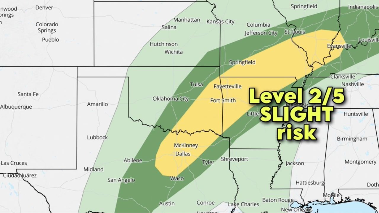
Slight Risk Issued From Texas to Illinois
The Storm Prediction Center (SPC) has outlined a Slight Risk (Level 2 out of 5) for severe storms across a band running through:
- North Texas, including Dallas and McKinney
- Southern and eastern Oklahoma
- Northwest Arkansas, including Fayetteville
- Western and central Arkansas, including Little Rock
- Southern Missouri, including Springfield
- Southern Illinois, including Carbondale
This zone sits within a broader region where thunderstorms may develop during the day as a weather system moves across the central United States.
Damaging Winds Up to 60 mph Possible
One of the main hazards today will be strong wind gusts reaching up to 60 mph in some thunderstorms.
A corridor of stronger wind potential extends across parts of:
- North Texas
- Eastern Oklahoma
- Arkansas
- Southern Missouri
- Southern Illinois
These wind gusts could cause localized tree damage, power outages, and hazardous driving conditions, particularly if storms organize into clusters or short lines.
Large Hail Also a Primary Threat
Another significant concern is large hail, with forecasters noting the possibility of hail reaching around quarter size in stronger storms.
The hail threat zone overlaps much of the same corridor running from Texas through Arkansas and into Missouri and Illinois, where storms may briefly intensify.
Large hail can damage vehicles, roofs, and crops, especially in stronger thunderstorm cells.
Tornado Threat Remains Low but Not Zero
While tornadoes are not expected to be the primary hazard, meteorologists say a brief tornado cannot be completely ruled out if a storm becomes organized enough.
However, current forecast data suggests the overall tornado risk remains relatively low compared with hail and wind threats.
Storm Coverage Expected to Increase Later This Week
Forecasters emphasize that today’s storms may only be the first stage of a more active severe weather pattern developing across the central United States.
As additional weather systems move through the region in the coming days, storm coverage and intensity could increase, potentially bringing stronger severe weather threats later in the week.
WaldronNews Monitoring Developing Storm Pattern
Residents across Texas, Oklahoma, Arkansas, Missouri, and southern Illinois should remain alert for changing weather conditions as storms begin to develop.
WaldronNews will continue tracking this developing severe weather pattern, providing updates on storm timing, impacts, and potential risks across the central United States.
Stay with WaldronNews.com for the latest severe weather updates and regional forecasts as this active weather period unfolds.