
Severe Storm Risk Builds Across Texas, Arkansas, Missouri and Illinois Around March 10 With Tornadoes Possible but Widespread Outbreak Unlikely
UNITED STATES — Forecast models are signaling a round of severe weather potential around the March 10 timeframe, stretching from Texas north through Arkansas, Missouri, and into parts of Illinois and Indiana. While the setup supports thunderstorms capable of producing tornadoes, damaging wind, and hail, current projections suggest the overall severity may remain limited rather than explosive.
Where Storm Potential Is Highest
The supercell composite parameter — a key indicator of organized severe storm potential — highlights a corridor of concern extending from:
- Central and eastern Texas
- Oklahoma
- Arkansas
- Missouri
- Western Tennessee
- Southern Illinois and Indiana
This zone shows favorable overlap of instability and wind shear, which are the two primary ingredients needed for rotating thunderstorms.
The highest concentration of supportive parameters appears centered over eastern Oklahoma into western Arkansas and southern Missouri.
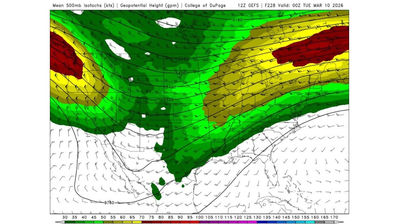
Jet Stream Setup Supports Storm Development
The 500mb jet stream forecast valid March 10 shows:
- Strong upper-level winds arcing from the southern Plains into the Midwest.
- A pronounced trough digging into the central U.S.
- Enhanced wind shear across Texas, Arkansas, Missouri, and Illinois.
Upper-level winds exceeding 80–100 knots across parts of the Midwest suggest the atmosphere will be dynamically active.
However, the strongest jet core remains displaced somewhat north of the deepest surface instability, which may limit the overall intensity compared to classic major outbreak setups.
Why This Doesn’t Look Like a Major Outbreak — Yet
Several factors appear to temper the threat:
- The strongest instability is focused mainly over Texas and the lower Mississippi Valley.
- The most intense upper-level support is farther north.
- Model guidance does not show an extreme, classic high-end tornado composite signal.
That said, tornadoes remain possible within any discrete storms that can develop ahead of the main line.
Even moderate setups can produce localized significant events.
Timing and Impacts
The March 10 timeframe suggests storms could develop during the late afternoon and evening hours as a cold front advances eastward.
Primary hazards may include:
- Damaging straight-line winds.
- Large hail in stronger supercells.
- Isolated tornadoes, especially in eastern Texas, Arkansas, and southern Missouri.
Storms may then track northeast into Illinois and Indiana overnight.
What Residents Should Do
Even though current data suggests the severity “shouldn’t be anything too bad,” severe weather is inherently dangerous.
Residents across:
- Texas
- Oklahoma
- Arkansas
- Missouri
- Illinois
- Indiana
should monitor forecast updates as the event approaches, especially since forecast details can sharpen significantly within 3–5 days.
Bottom Line
A classic early-spring severe weather setup is developing across the central United States around March 10. While this does not currently resemble a widespread, high-end tornado outbreak, the ingredients are sufficient for organized severe storms and possible tornadoes.
Stay with WaldronNews.com for updated severe weather outlooks as confidence increases and storm details become clearer.