
Severe Storm Setup Tuesday Across Missouri Illinois Indiana Michigan and Wisconsin Could Bring Damaging Winds and Possible Tornadoes
MISSOURI — Meteorologists are closely watching a developing severe weather setup that could bring strong thunderstorms, damaging winds and possible tornadoes across Missouri, Illinois, Indiana, Michigan and Wisconsin on Tuesday as a powerful storm system moves across the Midwest.
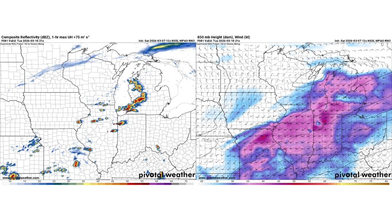
Early forecast guidance from high-resolution models suggests that storms could organize into clusters or a broken line of thunderstorms stretching from Missouri into Illinois and eventually toward Michigan, creating a corridor of severe weather potential across several Midwest states.
While forecasters caution that model guidance this far in advance remains uncertain, the evolving pattern shows a setup that could support strong storms if the atmosphere becomes unstable enough.
Storm Development Possible from Missouri Into Michigan
One of the model scenarios indicates thunderstorms beginning to develop across Missouri and southern Illinois, before expanding northeast through central Illinois, Indiana and eventually parts of Michigan.
Weather maps show pockets of intense storm activity forming along a north-south oriented boundary, with stronger storms appearing in:
- Missouri
- Illinois
- Indiana
- Lower Michigan
These storms could gradually organize into a line of severe thunderstorms capable of producing strong wind gusts and localized severe weather as they track northeast.
Strong Wind Energy Building Across the Midwest
Upper-level and mid-level wind maps show a strong corridor of wind energy spreading across Missouri, Illinois, Indiana and Michigan, which is one of the key ingredients that helps thunderstorms intensify.
When strong winds exist at multiple levels of the atmosphere, storms are more likely to organize and rotate. This increases the risk of:
- Damaging straight-line winds
- Large hail
- Isolated tornadoes
The strongest atmospheric wind fields appear to extend from Missouri into Illinois and Indiana before reaching parts of Michigan, which could help storms maintain strength as they travel across the region.
Michigan Could See Stronger Storm Clusters
Forecast guidance shows several clusters of thunderstorms developing near southern and central portions of Lower Michigan, with the strongest storms potentially forming near areas such as:
- Grand Rapids
- Lansing
- Flint
- Detroit
If these storms organize into stronger cells or lines, they could produce localized damaging winds and brief tornadoes, particularly during the late afternoon or evening hours.
However, meteorologists stress that the exact storm track and intensity will depend heavily on how instability develops across the region during the day.
Forecast Uncertainty Remains This Far Out
Because the system is still several days away, forecasters note that high-resolution storm models like MPAS and other CAM guidance can change significantly as the event approaches.
Some model scenarios show scattered storms, while others suggest a more organized line of severe thunderstorms across parts of the Midwest.
Small changes in the placement of warm air, moisture and atmospheric instability could shift the area of greatest severe weather risk north or south.
Residents Should Monitor Forecast Updates
Even though the exact outcome is still uncertain, the evolving weather pattern suggests that parts of Missouri, Illinois, Indiana, Michigan and Wisconsin could experience strong thunderstorms Tuesday.
Residents across the region should remain aware of forecast updates as meteorologists continue refining the storm outlook.
As the event gets closer, forecast confidence will improve and the exact timing and intensity of storms will become clearer.
Stay with WaldronNews.com for continuing updates as meteorologists track the developing severe weather threat across the Midwest.