
Severe Storm Threat Builds Across Western Texas, Western Oklahoma, and Southern Kansas as Supercell Potential Emerges on March 5
WESTERN TEXAS — A developing severe weather setup could bring dangerous storms to parts of the Southern Plains on Thursday, March 5, 2026, with meteorologists highlighting western Texas, western Oklahoma, and southern Kansas as the primary areas to watch for potential supercell thunderstorms.
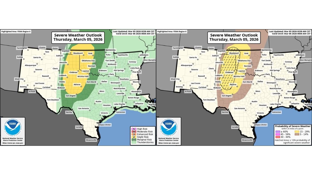
Forecast guidance currently places the region under a Slight Risk (Level 2 of 5) for severe weather, meaning scattered severe storms are possible. Forecasters say the threat could increase if atmospheric conditions align for supercell development, which may lead to stronger storms capable of producing damaging weather.
Slight Risk Area Covers Large Portion of the Southern Plains
According to the latest Severe Weather Outlook for March 5, the Slight Risk zone stretches from western Texas northward into western Oklahoma and southern Kansas. Cities located within or near this risk area include:
- Amarillo, Texas
- Lubbock, Texas
- Midland, Texas
- San Angelo, Texas
- Childress, Texas
- Woodward, Oklahoma
- Enid, Oklahoma
- Dalhart, Texas
- Guymon, Oklahoma
Surrounding regions — including Dallas, Fort Worth, Oklahoma City, Austin, San Antonio, and Tulsa — fall within a Marginal Risk zone, where isolated strong storms may still occur.
The risk area extends across much of the Texas Panhandle, western Oklahoma, and southern Kansas, forming a corridor where atmospheric instability and wind shear could support organized thunderstorms.
Supercell Development Could Increase the Threat
Meteorologists note that the severe weather outlook could be upgraded if forecast models show stronger confidence in supercell formation and timing.
Supercells are rotating thunderstorms capable of producing some of the most dangerous forms of severe weather, including:
- Large hail
- Damaging wind gusts
- Isolated tornadoes
The forecast probability maps show a 15% chance of severe weather within 25 miles of a location across the core risk area, which meets the criteria for a Slight Risk classification.
In addition, a hatched region indicating a 10% probability of significant severe weather highlights parts of western Texas and western Oklahoma, signaling the potential for more impactful storms if conditions become favorable.
Areas Most Likely to See Severe Storms
Based on the latest forecast data, the most active storm zone may develop along a corridor from the Texas Panhandle into western Oklahoma, including areas around:
- Amarillo
- Childress
- Lubbock
- Midland
- Woodward
Storms forming in this region could then track northeast toward southern Kansas during the evening hours.
However, meteorologists emphasize that storm coverage and intensity will depend heavily on how quickly atmospheric instability develops and whether storms can become organized early in the event.
Timing of the Severe Weather Risk
The severe weather threat is expected to develop Thursday afternoon into the evening hours, when daytime heating and strengthening wind patterns in the upper atmosphere could help storms intensify.
Early storms may form over western Texas, with activity spreading north and northeast toward western Oklahoma and southern Kansas later in the day.
Forecasters are continuing to monitor:
- Increasing instability
- Wind shear supportive of rotating storms
- Potential storm clustering into organized systems
Any of these factors could influence whether the risk level is increased in future outlook updates.
Forecast Could Still Change
While the current outlook highlights a Slight Risk, meteorologists say the situation is still evolving.
If future forecast runs show stronger atmospheric instability or clearer signals for supercell formation, parts of the region could see a higher severe weather risk level in later updates.
Residents across the Texas Panhandle, western Oklahoma, and southern Kansas are encouraged to stay alert to updated forecasts and be prepared for rapidly changing weather conditions.
Stay with WaldronNews.com for continuing updates as meteorologists track the developing severe weather threat across the Southern Plains heading into Thursday.