
Severe Storm Threat Expands Across Illinois, Indiana, Ohio, and Kentucky on Thursday Evening as Midwest Low Tracks East
UNITED STATES — A developing storm system is expected to bring a risk of strong to severe thunderstorms Thursday afternoon and evening, February 19, across parts of the Midwest and Ohio Valley, including Illinois, Indiana, Ohio, and Kentucky.
Forecast guidance highlights a broad risk zone centered over the central Ohio Valley, with multiple modes of severe weather possible as the system tracks east.
Risk Zone Centers on the Ohio Valley
The severe weather outlook map shows the highest concentration of risk stretching from:
- Central and southern Illinois
- Central and southern Indiana
- Western and central Ohio
- Northern and central Kentucky
- Into parts of Tennessee and western West Virginia
The most concentrated area appears near the Indiana–Ohio–Kentucky corridor, where instability and wind energy are expected to overlap Thursday evening.
While this is not yet a high-end outbreak signal, the setup supports organized thunderstorms capable of becoming severe.
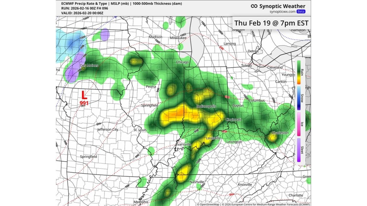
Developing 991mb Low Adds Energy to the System
Model data valid Thursday evening shows a 991mb surface low tracking through the Midwest, with a strong pressure gradient extending across Illinois and Indiana.
At approximately 7 PM EST Thursday:
- Bands of heavier rainfall and embedded thunderstorms are forecast from eastern Illinois through Indianapolis, Cincinnati, and into western Ohio.
- A secondary line extends southward toward Louisville and Nashville.
- Moisture return from the south feeds into the warm sector ahead of the advancing cold front.
This pattern supports:
- Damaging wind gusts
- Large hail
- Isolated tornado potential
- Heavy downpours leading to localized flooding
Exact storm mode — whether discrete cells or a more linear squall line — will become clearer as higher-resolution data becomes available.
Timing: Afternoon Development, Evening Intensification
Current projections suggest:
- Storm development begins in Illinois and Missouri Thursday afternoon
- Stronger storms shift into Indiana and Kentucky by late afternoon
- Peak impacts likely across Ohio and northern Kentucky Thursday evening
Communities including Chicago (southern suburbs), Peoria, Springfield, Indianapolis, Dayton, Cincinnati, Louisville, and Columbus may all need to monitor forecast updates closely.
What Makes This Setup Noteworthy
Forecasters note that all severe weather hazards remain on the table at this stage. With strengthening wind fields aloft and increasing surface instability, even February systems can produce impactful storms in this region.
While this is not yet classified as a major outbreak scenario, the overlapping ingredients warrant close attention over the next 48 hours.
Small changes in:
- The track of the low pressure center
- The speed of the cold front
- Available instability
Could increase or decrease the overall threat level.
What Residents Should Do Now
Residents across Illinois, Indiana, Ohio, Kentucky, Tennessee, and surrounding states should:
- Review severe weather safety plans
- Ensure weather alerts are enabled
- Stay updated on forecast changes through midweek
February severe events can escalate quickly, especially during evening hours when visibility decreases.
WaldronNews.com will continue monitoring this developing system and provide updates as newer model data refines the storm track and severity potential.