
Severe Storm Threat Tuesday Across Texas Louisiana Arkansas Missouri Illinois and Indiana With Damaging Winds Large Hail and Possible Tornadoes
ARKANSAS — A new severe weather setup is expected to develop Tuesday across a large stretch of the central United States, with meteorologists warning that widespread thunderstorms capable of damaging winds, large hail, and possible tornadoes could impact multiple states including Texas, Louisiana, Arkansas, Missouri, Illinois, and Indiana.
Forecast data shows a broad corridor of storm development stretching from the Southern Plains into the Mid-Mississippi Valley and parts of the Midwest, signaling the potential for organized severe weather as atmospheric conditions become more favorable during the day.
Storm Corridor Expected from Texas to Illinois
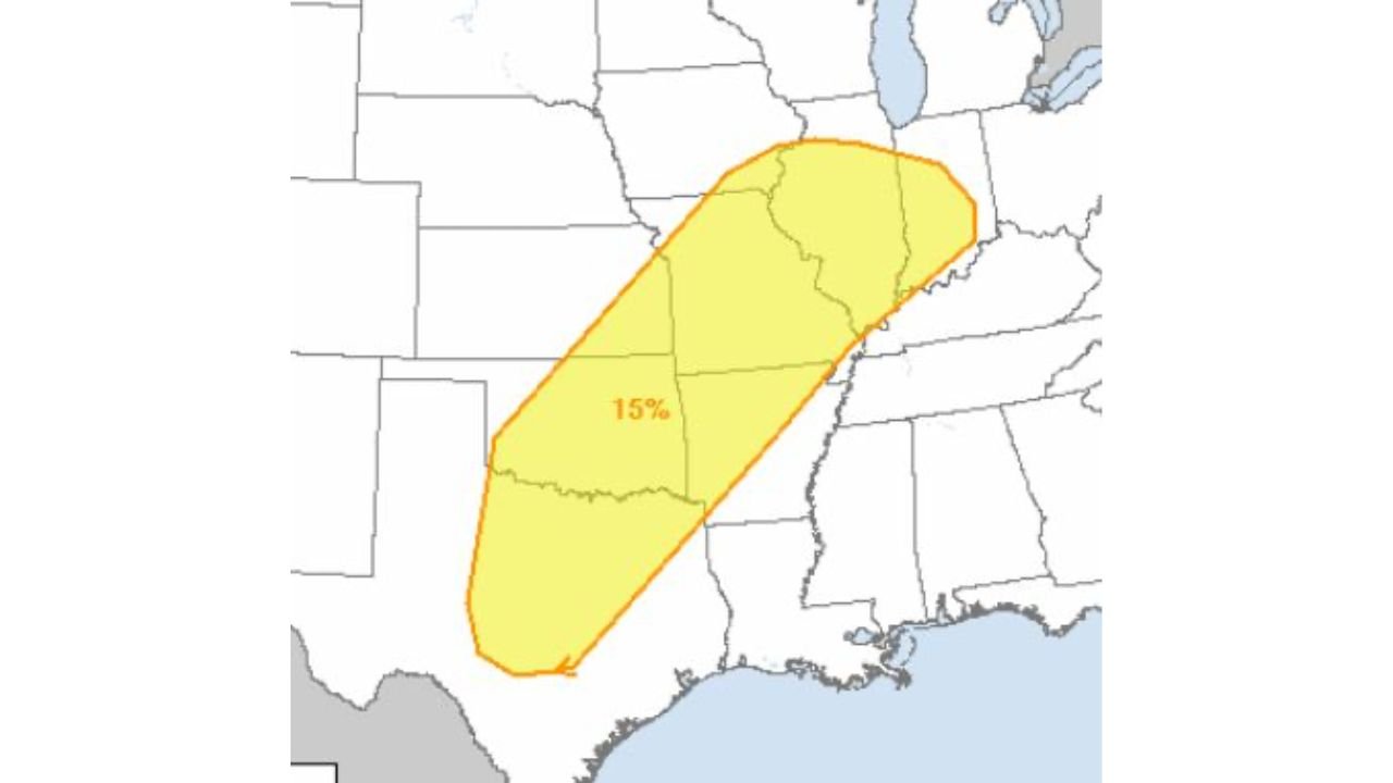
The current severe weather outlook highlights a 15% severe storm risk zone extending diagonally from eastern Texas northeastward through Louisiana and Arkansas, continuing into Missouri and reaching parts of Illinois and Indiana.
This type of corridor often develops when warm, moisture-rich air from the Gulf of Mexico collides with a stronger upper-level weather system moving east across the Plains. When these ingredients combine, thunderstorms can intensify rapidly and organize into clusters or squall lines capable of producing severe conditions.
Communities located within this highlighted zone could see:
- Damaging wind gusts capable of downing trees and power lines
- Large hail that may cause damage to vehicles, roofs, and crops
- Isolated tornadoes forming within stronger rotating storm cells
While the entire region has some level of risk, Arkansas and Missouri sit near the center of the storm corridor, meaning storms traveling through these areas could become particularly organized as they track northeast.
Arkansas and Missouri May See Stronger Storm Development
For Arkansas, including communities such as Waldron and surrounding areas, Tuesday may bring periods of strong thunderstorms moving through the region during the afternoon and evening hours.
Meteorologists indicate that storm intensity will largely depend on how quickly the atmosphere destabilizes during the day. If temperatures warm enough and moisture increases, storms could strengthen rapidly as they move across the state.
Potential impacts across Arkansas may include:
- Strong straight-line winds within thunderstorm lines
- Large hail produced by stronger updrafts
- Brief tornadoes developing if storm rotation occurs
Storms developing in eastern Texas and Louisiana during the day could gradually strengthen as they track northeast into Arkansas and Missouri, before continuing toward Illinois and Indiana later Tuesday or Tuesday night.
Severe Weather Season Beginning to Build
The developing storm system is another sign that severe weather season is beginning to ramp up across the central United States. Early spring often brings stronger weather contrasts across the country, allowing powerful storm systems to form when warm southern air interacts with colder northern air masses.
These setups can create the right combination of instability, wind shear, and moisture, which are key ingredients needed for severe thunderstorms and tornado development.
Meteorologists will be closely monitoring the evolving atmospheric conditions leading up to Tuesday, as small changes in storm timing or instability levels could affect how intense the storms become.
Residents Urged to Stay Alert
Although not every area inside the outlook will experience severe storms, officials advise residents across Texas, Louisiana, Arkansas, Missouri, Illinois, and Indiana to stay weather aware throughout Tuesday.
Strong storms can develop quickly during spring weather patterns, and having access to updated forecasts and weather alerts can be critical during rapidly changing conditions.
Residents should make sure they have multiple ways to receive severe weather warnings and review their safety plans ahead of the approaching storm system.
Stay with WaldronNews.com for continued updates as meteorologists track the developing severe weather threat expected to move across the region Tuesday.