
Severe Thunderstorm Risk Targets Tampa Bay and Southwest Florida as Strong Storm Line Moves In Sunday, February 15
Tampa Bay, Florida — A developing line of strong thunderstorms is expected to move across the Tampa Bay region and southwest Florida Sunday afternoon and evening, bringing the potential for gusty winds, heavy rain, and isolated severe weather. The latest outlook highlights much of the region under at least a marginal to slight risk, with some northern counties facing a higher threat level as conditions become more unstable.
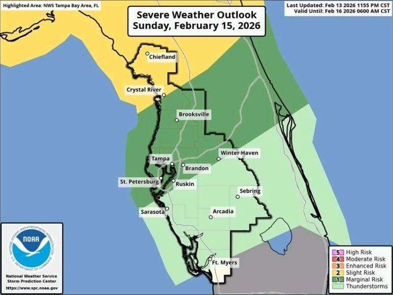
According to the Severe Weather Outlook for Sunday, February 15, 2026, a concentrated line of storms will sweep from north to south through the afternoon and into the evening hours. While not every community will see severe conditions, forecasters caution that a few storms could become rather strong, particularly as they interact with warmer Gulf air.
What Happened and When
The updated outlook, valid through early Monday morning, shows a broad swath of risk stretching from the Nature Coast down through Tampa Bay and into parts of southwest Florida . The highest concern appears across Chiefland, Crystal River, and areas north of Brooksville, where a slight risk zone is indicated.
Farther south, cities including Tampa, St. Petersburg, Brandon, Ruskin, Sarasota, Arcadia, Sebring, Winter Haven, and Fort Myers remain under a marginal risk, meaning isolated strong storms are possible. These areas could see brief periods of intense rainfall and wind gusts capable of downing small tree limbs or causing localized power outages.
The most active period is expected Sunday afternoon through the evening, as the line of storms advances eastward and southeastward across the peninsula. Conditions are expected to calm overnight as the system moves offshore.
Areas Under the Greatest Risk
The Nature Coast region, particularly near Chiefland and Crystal River, sits in the more pronounced threat zone. A slight risk designation typically indicates scattered severe storms are possible, with damaging wind gusts being the primary concern.
Communities in and around Brooksville and northern Hernando County may also see stronger storm development as atmospheric instability increases during peak daytime heating. While tornado potential appears limited, forecasters note that brief spin-ups cannot be ruled out within stronger storm cells embedded in the line.
In the Tampa Bay metro area, including Tampa and St. Petersburg, the risk level is lower but still significant enough for residents to monitor conditions. Even marginal-risk storms can produce sudden downpours that reduce visibility and create hazardous driving conditions.
Weather Warnings and Safety Information
Residents across Hillsborough, Pinellas, Hernando, Citrus, Polk, Hardee, DeSoto, and Lee counties should remain weather-aware throughout Sunday. Officials recommend:
- Monitoring local weather updates during the afternoon and evening
- Securing outdoor furniture and loose items
- Charging mobile devices in case of power outages
- Avoiding unnecessary travel during heavy storms
If a Severe Thunderstorm Warning is issued, residents should move indoors immediately and stay away from windows. While the risk of widespread damage remains low, even isolated severe storms can produce wind gusts over 50 mph and dangerous lightning.
Local Impact and What Comes Next
Though the storm system is not expected to produce a prolonged severe weather outbreak, it serves as a reminder that Florida’s late-winter weather can quickly turn active, especially when Gulf moisture combines with a passing front.
For communities across Tampa Bay and southwest Florida, Sunday’s storms could bring temporary disruptions to outdoor plans, including Valentine’s Day weekend events. Emergency managers will continue monitoring radar trends to determine if additional advisories are needed.
Conditions are expected to improve overnight Sunday into early Monday, with drier air filtering into the region behind the storm line. Cooler and calmer weather may follow, offering a brief break before the next weather system develops later in the week.
Residents are encouraged to follow WaldronNews.com for continued updates on severe weather developments and important safety information as this system moves through Florida. Staying informed and prepared remains the best defense against sudden storm threats.