
Severe Thunderstorms Target Texas, Oklahoma, Kansas and Western Arkansas on Wednesday With Large Hail, Isolated Tornadoes and 70+ MPH Winds Possible
UNITED STATES — A strengthening storm system moving across the Plains is expected to trigger severe thunderstorms on Wednesday, impacting parts of Texas, Oklahoma, Kansas and western Arkansas, including areas near Fort Smith.
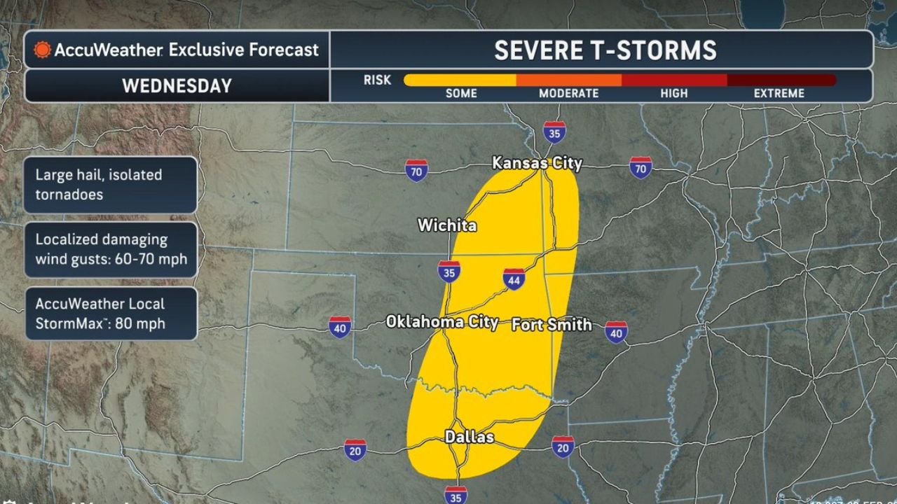
Forecast guidance highlights a corridor of severe thunderstorm risk stretching from north Texas through central and eastern Oklahoma into southern Kansas and western Arkansas.
Cities and States in the Risk Zone
The highlighted severe threat zone includes:
- Texas: Dallas and surrounding north Texas communities
- Oklahoma: Oklahoma City and much of central and eastern Oklahoma
- Kansas: Wichita and areas extending toward Kansas City
- Arkansas: Western portions of the state, including Fort Smith
The risk corridor runs generally south to north, following a classic Plains severe weather setup.
Primary Threats on Wednesday
Forecasters are indicating several potential hazards:
- Large hail
- Isolated tornadoes
- Localized damaging wind gusts of 60 to 70 mph
- AccuWeather Local StormMax gusts up to 80 mph
These conditions suggest the possibility of organized thunderstorms, including supercells, especially during the afternoon and evening hours.
Why This Setup Matters for Western Arkansas
Western Arkansas, including communities near Fort Smith and the Arkansas River Valley, lies near the eastern edge of the highlighted zone. Storms developing in Oklahoma could track eastward into Arkansas during the late afternoon or evening.
Residents across western Arkansas should be alert for:
- Rapidly intensifying storms
- Strong wind gusts capable of downing trees and power lines
- Large hail that could damage vehicles and roofs
Even if the strongest core of activity remains just west of the Arkansas border, storm systems often expand or shift as they mature.
Multi Day Pattern Developing
This Wednesday system may not be a one day event. Multiple disturbances are expected to move across the Plains and Ohio Valley next week, increasing the potential for repeated rounds of heavy rain and severe storms.
With saturated soils possible in some areas, localized flooding could also become a concern depending on rainfall totals.
What to Watch Next
Forecast details will continue to evolve, especially regarding:
- Exact storm timing
- Tornado potential
- Rainfall amounts
- Eastward expansion into additional Arkansas counties
Residents in Texas, Oklahoma, Kansas and western Arkansas should begin reviewing severe weather safety plans and ensure weather alerts are enabled on mobile devices.
WaldronNews.com will continue tracking updates and provide Arkansas specific details as confidence increases in the days ahead.