
Severe Weather Alert Expands for Texas, Oklahoma, Kansas, Missouri, Arkansas, Illinois and Indiana as April 13 Setup Raises Major Concerns
CENTRAL AND SOUTHERN PLAINS TO MIDWEST — A significant shift toward an active and potentially dangerous severe weather pattern is now emerging across the United States, with April 13 being closely watched as a key day for widespread severe storms stretching from the Plains into the Midwest.
This developing setup is being flagged as a high-impact multi-day threat window, and residents across multiple states are being urged to stay alert.
A Rapid Pattern Shift Begins This Week
Weather signals clearly show that conditions will turn much more active starting around April 9 and continuing through at least April 22.
This is not a single storm event — instead, it is shaping up to be:
- A prolonged severe weather stretch
- Multiple rounds of storms across several days
- Increasing potential for large-scale severe outbreaks
The pattern suggests frequent storm development rather than isolated events, raising the overall risk level.
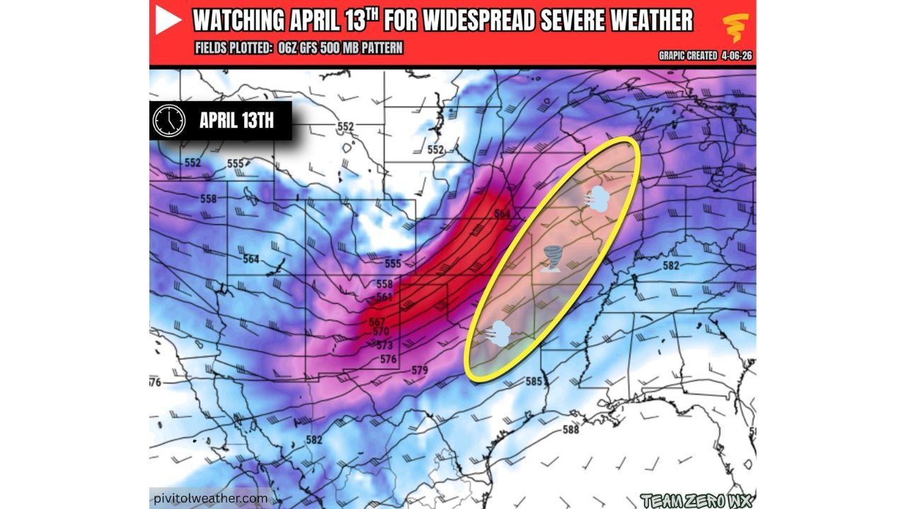
April 13 Highlighted as a Key Severe Weather Day
Among all days in this window, April 13 stands out as a major day to watch.
The upper-level pattern indicates:
- A strong trough moving across the Plains
- Enhanced wind energy spreading into the Midwest
- A broad zone supportive of organized severe storms
The highest concern zone currently stretches across:
- Texas
- Oklahoma
- Kansas
- Missouri
- Arkansas
- Extending into Illinois and Indiana
This corridor represents a classic setup for multi-hazard severe weather, including:
- Tornado potential
- Damaging straight-line winds
- Large hail events
Why This Setup Is Concerning
The atmospheric pattern shown suggests:
- Strong jet stream energy overhead
- Favorable storm organization conditions
- A wide geographic coverage area
Even though specific details remain uncertain at this range, the overall structure strongly supports a widespread severe weather scenario rather than localized storms.
This is the type of setup that can lead to:
- Regional severe outbreaks
- Multiple states impacted at once
- Rapid storm intensification during peak hours
Not Just One Day — A Multi-Day Threat Window
What makes this situation more serious is the extended timeline.
From April 9 through April 22:
- Several storm systems may track across the same regions
- Risk areas could shift day to day
- Recovery time between events may be limited
This increases the chances of:
- Repeated impacts
- Soil saturation and flooding in some areas
- Elevated stress on emergency response systems
Midwest Expansion Adds More Concern
Unlike early-season setups that stay confined to the Plains, this pattern shows storms pushing deeper into the Midwest.
States like:
- Illinois
- Indiana
could see increasing severe weather risks, especially around April 13 as the system lifts northeast.
What Residents Should Watch Closely
This is an evolving situation, but early signals suggest:
- High-confidence active pattern
- Moderate confidence in April 13 being a key day
- Lower confidence in exact storm locations this far out
Residents should:
- Monitor daily forecast updates
- Stay aware of changing risk zones
- Prepare for possible severe weather alerts
A Pattern That Demands Attention
This setup is not being treated as routine. The combination of timing, duration, and geographic coverage points toward a potentially impactful severe weather period across the central U.S.
As April approaches mid-month, the atmosphere appears ready to shift into a much more volatile state, and April 13 could be the first major test of that pattern.
Stay with WaldronNews.com as this developing severe weather threat continues to evolve across Texas, Oklahoma, Kansas, Missouri, Arkansas, Illinois, and Indiana.