
Severe Weather Alert Issued for Texas, Oklahoma, Kansas, Missouri and Iowa as Multi-Day Storm Pattern Targets Central U.S.
UNITED STATES — A major mid-April severe weather alert has been issued across the Central United States, as new forecast data signals a high-frequency storm pattern that could bring repeated severe weather chances over the next two weeks.
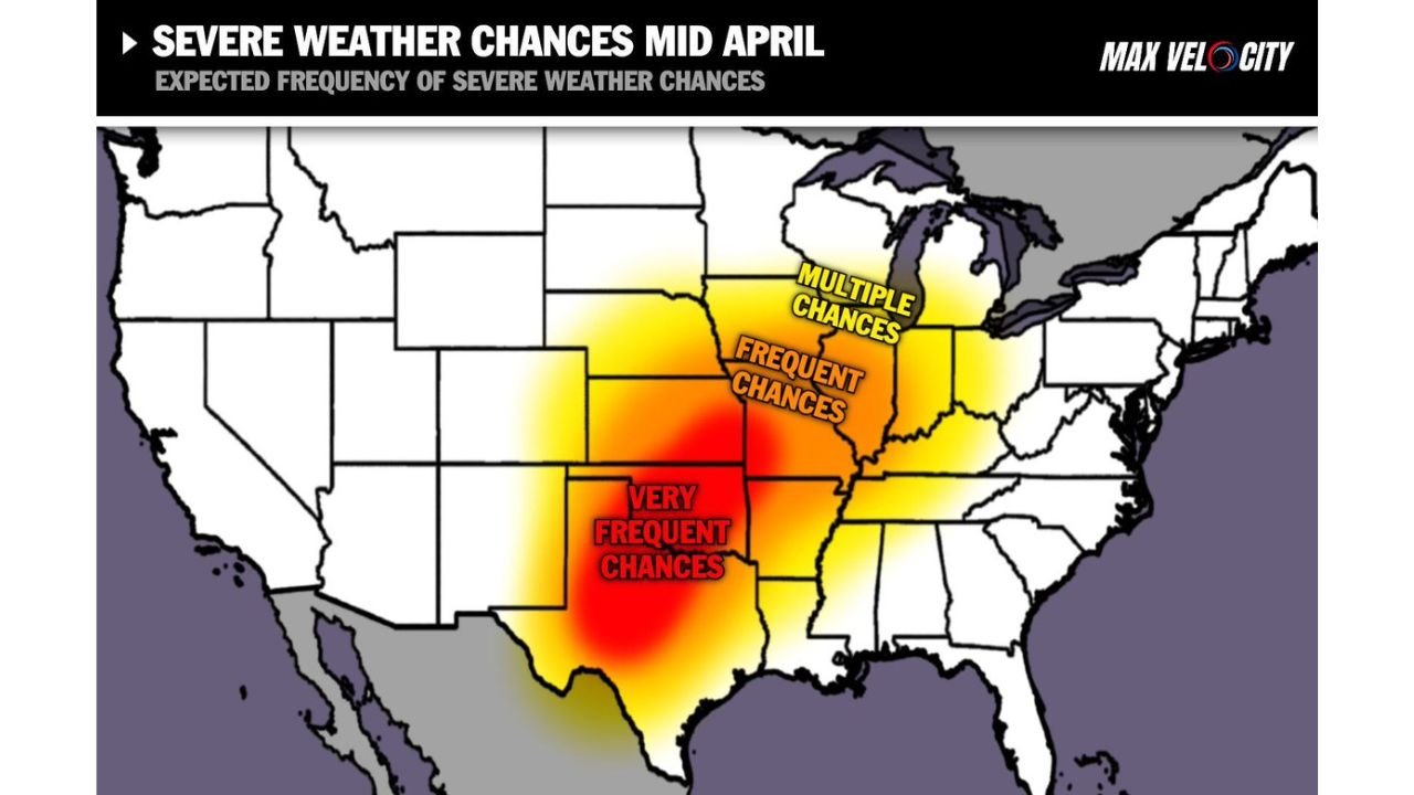
This setup highlights a broad and dangerous corridor from Texas through Oklahoma, Kansas, Missouri, and into Iowa, where conditions are expected to support frequent to very frequent severe storm development.
Core Severe Weather Zone Identified
Forecast guidance clearly outlines three levels of concern across the region:
- Very Frequent Severe Weather Zone → Texas and Oklahoma
- Frequent Severe Weather Zone → Kansas and Missouri
- Multiple Severe Weather Chances → Iowa and surrounding Midwest areas
This structure indicates a progressive storm track, where systems repeatedly form in the Southern Plains and move northeast.
Why This Pattern Is Significant
This is not a typical short-term event. Instead, it is a long-duration active pattern, meaning:
- Severe storms could occur on multiple days in a row
- The same regions may be impacted repeatedly
- Storm intensity could vary but remain consistently present
This type of setup dramatically increases the risk of accumulated impacts over time.
Timeline of the Developing Pattern
The active stretch is expected to begin:
- As early as Thursday → Initial storm development
- Continuing through the following days and into mid-April
- Potential for near-daily storm chances in some regions
This suggests a persistent weather pattern rather than isolated outbreaks.
Areas Facing the Highest Risk
The most concerning regions include:
- North and Central Texas
- Oklahoma
- Kansas
- Missouri
- Extending into Iowa and parts of the Midwest
These areas fall directly within the highlighted severe weather corridor, where atmospheric conditions will be most supportive.
What Types of Severe Weather Are Possible
As this pattern unfolds, residents should be prepared for:
- Severe thunderstorms
- Damaging wind events
- Large hail potential
- Possible tornado development, especially in peak zones
The repeated nature of the pattern increases the likelihood that multiple hazards could occur over several days.
Pattern Driven by Strong Atmospheric Setup
The environment is being shaped by:
- A favorable jet stream alignment
- Continuous energy moving across the Plains
- Persistent moisture feeding into storm systems
This combination creates a classic severe weather setup across the central U.S..
What Residents Should Expect
With this pattern in place:
- Expect frequent weather alerts and updates
- Conditions may change quickly from calm to severe
- Some areas could experience multiple rounds of storms in a short time span
Preparedness will be critical, especially in regions expecting very frequent storm activity.
Situation Requires Close Attention
This developing pattern represents one of the more active severe weather stretches of the season so far, with the potential to impact millions across multiple states.
The combination of duration, frequency, and geographic coverage makes this a situation that should be closely monitored.
Stay with WaldronNews.com for continuing coverage as this multi-day severe weather pattern intensifies across the Plains and Midwest through mid-April.