
Severe Weather Returns Saturday Across Texas, Louisiana and Mississippi With Large Hail, Damaging Winds and Isolated Tornado Threat
UNITED STATES — Severe weather is expected to make a return this weekend across parts of Texas and neighboring Gulf Coast states, with the Storm Prediction Center outlining a risk area for Saturday, February 14, 2026.
The highlighted region includes a broad portion of central and eastern Texas, extending into western Louisiana and parts of southern Arkansas and Mississippi. While this is not currently a high-end outbreak setup, conditions will support organized thunderstorms capable of producing large hail, damaging wind gusts, and a couple of tornadoes.
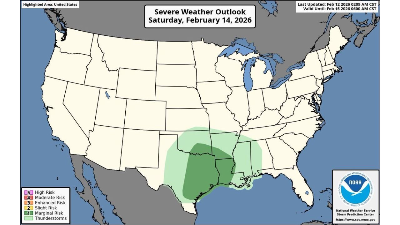
Saturday’s Highlighted Risk Area
The severe weather outlook map shows a Marginal Risk (Level 1 of 5) spanning:
- Much of central and east Texas
- Areas along the Texas Gulf Coast
- Western and central Louisiana
- Portions of southern Arkansas
- Western Mississippi
Cities within or near the risk zone include:
- Dallas
- Houston
- Austin
- San Antonio
- Shreveport
- Baton Rouge
The setup suggests storms will develop and organize as a system moves across the Southern Plains into the Lower Mississippi Valley.
Main Hazards: Hail and Wind
Forecasters indicate that large hail and damaging straight-line winds will be the primary concerns.
- Hail could become significant in stronger, discrete storms.
- Wind gusts may exceed severe thresholds in any organized line segments.
The presence of adequate wind shear also means that a couple of tornadoes cannot be ruled out, especially in areas where storms remain semi-discrete before merging into lines.
Why This Pattern Is Notable
Mid-February severe weather events are not unusual across Texas and the Gulf Coast, but this system signals the beginning of a more active stretch.
Moisture return from the Gulf of Mexico combined with increasing upper-level dynamics is setting the stage for early-season thunderstorm development. This type of setup often becomes more frequent as we move closer to spring.
While the current outlook is categorized at the lower end of the risk scale, residents should not dismiss it. Even marginal risk days can produce isolated but impactful severe storms.
Timing and What to Watch
Storm development is most likely during the afternoon and evening hours Saturday.
Residents in the risk zone should monitor:
- Updated SPC outlooks
- Local National Weather Service alerts
- Rapid changes in storm intensity during peak heating hours
Those with outdoor plans across Texas, Louisiana, and Mississippi should remain weather-aware.
Looking Ahead
As severe weather season begins to ramp up, this weekend’s event may be an early signal of a more active pattern ahead.
WaldronNews.com will continue tracking updates and provide new information if the risk level increases or expands in the coming days.